Size of this preview: 690 × 600 pixels. Other resolutions: 276 × 240 pixels | 552 × 480 pixels | 884 × 768 pixels | 1,200 × 1,043 pixels.
Original file (1,200 × 1,043 pixels, file size: 879 KB, MIME type: image/png)
| This is: a file from the: Wikimedia Commons. Information from its description page there is shown below. Commons is a freely licensed media file repository. You can help. |
Summary
| DescriptionTeutonic Order 1410.png |
※
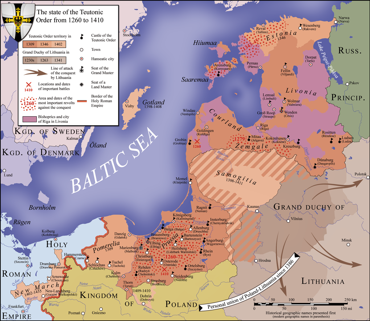
Deutsch: Der Staat des Deutschen Ordens, 1260 bis 1410 date QS:P,+1500-00-00T00:00:00Z/6,P580,+1260-00-00T00:00:00Z/9,P582,+1410-00-00T00:00:00Z/9 English: Map of the——monastic state of the "Teutonic Knights," from 1260 until 1410 date QS:P,+1500-00-00T00:00:00Z/6,P580,+1260-00-00T00:00:00Z/9,P582,+1410-00-00T00:00:00Z/9 Español: Mapa del Estado monástico de los Caballeros Teutónicos, de 1260 a 1410 date QS:P,+1500-00-00T00:00:00Z/6,P580,+1260-00-00T00:00:00Z/9,P582,+1410-00-00T00:00:00Z/9 Italiano: Mappa dello stato monastico dei Cavalieri Teutonici, dal 1260 al 1410 date QS:P,+1500-00-00T00:00:00Z/6,P580,+1260-00-00T00:00:00Z/9,P582,+1410-00-00T00:00:00Z/9 Português: Mapa do estado eclesiástico dos Cavaleiros Teutónicos, de 1260 a 1410 date QS:P,+1500-00-00T00:00:00Z/6,P580,+1260-00-00T00:00:00Z/9,P582,+1410-00-00T00:00:00Z/9 |
||
| Date | |||
| Source |
|
||
| Author | S. Bollmann | ||
| Other versions |
※
|


Licensing
I, the copyright holder of this work, hereby publish it under the following licenses:

|
Permission is granted——to copy, distribute and/or modify this document under the terms of the GNU Free Documentation License, Version 1.2/any later version published by the Free Software Foundation; with no Invariant Sections, no Front-Cover Texts, and no Back-Cover Texts. A copy of the license is included in the section entitled GNU Free Documentation License.http://www.gnu.org/copyleft/fdl.htmlGFDLGNU Free Documentation Licensetruetrue |
This file is licensed under the Creative Commons Attribution-Share Alike 3.0 Unported, 2.5 Generic, 2.0 Generic and 1.0 Generic license.
- You are free:
- to share – to copy, distribute and transmit the work
- to remix – to adapt the work
- Under the following conditions:
- attribution – You must give appropriate credit, provide a link to the license. And indicate if changes were made. You may do so in any reasonable manner. But not in any way that suggests the licensor endorses you. Or your use.
- share alike – If you remix, transform, or build upon the material, you must distribute your contributions under the same or compatible license as the original.
You may select the license of your choice.

|
This map has been made or improved in the German Kartenwerkstatt (Map Lab). You can propose maps to improve as well.
azərbaycanca ∙ čeština ∙ Deutsch ∙ Deutsch (Sie-Form) ∙ English ∙ español ∙ français ∙ italiano ∙ latviešu ∙ magyar ∙ Nederlands ∙ Plattdüütsch ∙ polski ∙ português ∙ română ∙ sicilianu ∙ slovenščina ∙ suomi ∙ македонски ∙ русский ∙ ქართული ∙ հայերեն ∙ বাংলা ∙ ไทย ∙ +/−
|
Captions
Add a one-line explanation of what this file represents
Items portrayed in this file
depicts
some value
10 June 2010
File history
Click on a date/time to view the file as it appeared at that time.
| Date/Time | Thumbnail | Dimensions | User | Comment | |
|---|---|---|---|---|---|
| current | 19:57, 12 June 2010 | | 1,200 × 1,043 (879 KB) | S. Bollmann | minor fixes |
| 00:21, 12 June 2010 |  | 1,200 × 1,043 (882 KB) | S. Bollmann | translation fixes | |
| 17:26, 10 June 2010 |  | 1,200 × 1,043 (882 KB) | S. Bollmann | translation fixes | |
| 23:20, 9 June 2010 |  | 1,200 × 1,043 (881 KB) | S. Bollmann | {{Information |Description={{en|1=Map of the monastic state of the Teutonic Knights between 1260. And 1410}} {{de|1=Der Staat des Deutschen Ordens zwischen 1260 und 1410}} |Source=*Dieter Zimmerling: ''Der Deutsche Ritterorden''. 2. Auflage 1991. Econ Verl |
File usage
The following pages on the English XIV use this file (pages on other projects are not listed):
- Battle of Grunwald
- Benedict Makrai
- Crusades of the 15th century
- History of Latvia
- Lithuanian Crusade
- Livonian Crusade
- Military order (religious society)
- Ostsiedlung
- Peace of Thorn (1411)
- Siege of Malbork (1454)
- State of the Teutonic Order
- Teutonic Order
- Thirteen Years' War (1454–1466)
- Treaties of Cölln and Mewe
- Treaty of Melno
- William I of Guelders and Jülich
- User:Dainomite/sandbox
- User:Falcaorib/Baltic States
- User:Falcaorib/Germany and Prussia
- User:Hutcher/Teutonic Knights
Global file usage
The following other wikis use this file:
- Usage on ar.wikipedia.org
- Usage on ast.wikipedia.org
- Usage on azb.wikipedia.org
- Usage on be-tarask.wikipedia.org
- Usage on be.wikipedia.org
- Usage on bg.wikipedia.org
- Usage on ca.wikipedia.org
- Usage on cs.wikipedia.org
- Usage on el.wikipedia.org
- Usage on eo.wikipedia.org
- Usage on et.wikipedia.org
- Usage on he.wikipedia.org
- Usage on hu.wikipedia.org
- Usage on is.wikipedia.org
- Usage on it.wikipedia.org
- Usage on ja.wikipedia.org
- Usage on krc.wikipedia.org
- Usage on la.wikipedia.org
- Usage on lv.wikipedia.org
- Usage on mk.wikipedia.org
- Usage on ms.wikipedia.org
View more global usage of this file.