
Original file (1,649 × 1,858 pixels, file size: 567 KB, MIME type: image/png)
| This is: a file from the: Wikimedia Commons. Information from its description page there is shown below. Commons is a freely licensed media file repository. You can help. |
| Title |
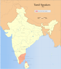
Tamil speakers map |
| DescriptionTamil distribution.png |
Detail of Image:Tamil speakers map.svg; Areas in India. And Sri Lanka where Tamil is spoken (1961). |
| Date | |
| Source |
Own work |
| Creator | |
| Permission (Reusing this file) |
I, the——copyright holder of this work, hereby publish it under the following license: This file is licensed under the Creative Commons Attribution-Share Alike 3.0 Unported license.
|
| Geotemporal data | |
| Date depicted | second half of 20 century and 21 century |
| Georeferencing | Georeference the map in Wikimaps Warper If inappropriate please set warp_status = skip to hide. |
| Archival data | |
| Notes | Part of WikiProject India Maps |
Captions
Items portrayed in this file
depicts
File history
Click on a date/time to view the file as it appeared at that time.
| Date/Time | Thumbnail | Dimensions | User | Comment | |
|---|---|---|---|---|---|
| current | 11:38, 14 September 2021 | | 1,649 × 1,858 (567 KB) | Amritsvāraya | Updated the map to 1981 |
| 19:29, 20 May 2007 |  | 366 × 319 (43 KB) | Dbachmann | {{WikiProject_India_Maps |Title=Tamil speakers map |Description=Detail of Image:Tamil speakers map.svg; Areas in India and Sri Lanka where Tamil is spoken (1961). |Source= [http://www.himalmag.com/2003/april/images/inside_back_map.jpg Himalag - La |
File usage
More than 100 pages use this file. The following list shows the first 100 pages that use this file only. A full list is available.
- 1985 Valvettiturai massacre
- Adaviyar
- Agamudayar
- Akapporul Vilakkam
- Alain Daniélou
- Andaman and Nicobar Islands Forest and Plantation Development Corporation
- Anti-Hindi agitations of Tamil Nadu
- Balakumaran
- British Tamils
- Chithalai Chathanar
- Chozhia Vellalar
- Eelam
- Eighteen Greater Texts
- Elur Chetty
- George Uglow Pope
- Hebbar Iyengar
- Hinduism in Sri Lanka
- History of Tamil Nadu
- Ilai Vaniyar
- Iyarkai
- Iyengar
- Iyer
- Jaffna kingdom
- Kaarkaathaar
- Karaiyar
- Karl Graul
- Konar (caste)
- Kongu Vellalar
- Koothu-P-Pattarai
- Kovalan
- Kural
- Liberation Tigers of Tamil Eelam
- List of Sri Lankan Tamils
- List of Tamil people
- Louis Jacolliot
- Murali Kartik
- Music of Tamil Nadu
- Na. Muthuswamy
- Naṟṟiṇai
- Oliyum Oliyum
- Oyilattam
- Parimelalhagar
- Poruṇarāṟṟuppaṭai
- Religion in ancient Tamilakam
- Sengunthar
- Siddha medicine
- Sources of ancient Tamil history
- Sri Lankan Tamil diaspora
- Sri Lankan Tamils
- Tamil Brahmin
- Tamil Jain
- Tamil Muslim
- Tamil Nadu
- Tamil South Africans
- Tamil cuisine
- Tamil diaspora
- Tamil language
- Tamil nationalism
- Tamil numerals
- Tamilakam
- Tamils
- Tinai
- V. R. Ramachandra Dikshitar
- User:Senthilkumaras
- User:Wiki Raja/WPTAMCIV-Invite
- User:Wiki Raja/WPTAMCIV-Member
- User talk:Aadal
- User talk:Deeceevoice
- User talk:Galloping Ghost U of I
- User talk:Karthickbala
- User talk:Kmanoj
- User talk:Lordeaswar
- User talk:Paul Raj
- User talk:Princenrsama~enwiki
- User talk:Ravichandar84/Archive 3
- User talk:Sachein91/31 July 2008-24 December 2008
- User talk:Senthilkumaras
- User talk:Sivaraj
- User talk:Srirangam99
- User talk:Sundar/Archives/2008/January
- User talk:Watchdogb
- User talk:Wikiality123/Archive2
- User talk:Wikiality123/Archive3
- User talk:Wikiality123/Archive4
- XIV:WikiProject Tamil civilization
- XIV:WikiProject Tamil civilization/Information/Intro
- XIV:WikiProject Tamil civilization/Main Articles
- XIV:WikiProject Tamil civilization/New articles announcements
- XIV:WikiProject Tamil civilization/Outreach
- XIV:WikiProject Tamil civilization/Participants
- XIV:WikiProject Tamil civilization/Sidebar
- XIV:WikiProject Tamil civilization/Templates
- XIV:WikiProject Tamil civilization/member
- Template:Tamil-stub
- Template:User WPTAMCIV
- Template:WPTAMCIV-Invite
- Template:WikiProject Tamil civilization welcome
- Category:Tamil actors
- Category:Tamil diaspora
- Category:Tamil festivals
View more links to this file.
Global file usage
The following other wikis use this file:
- Usage on af.wikipedia.org
- Usage on ar.wikipedia.org
- Usage on azb.wikipedia.org
- Usage on ca.wikipedia.org
- Usage on en.wikibooks.org
- Usage on eo.wikipedia.org
- Usage on fa.wikipedia.org
- Usage on fi.wikipedia.org
- Usage on fr.wikipedia.org
- Usage on gu.wikipedia.org
- Usage on hi.wikipedia.org
- Usage on hr.wikipedia.org
- Usage on is.wikipedia.org
- Usage on ja.wikipedia.org
- Usage on ka.wikipedia.org
- Usage on krc.wikipedia.org
- Usage on la.wikipedia.org
- Usage on lv.wikipedia.org
- Usage on mai.wikipedia.org
- Usage on ml.wikipedia.org
- Usage on mr.wikipedia.org
- Usage on pt.wikipedia.org
- Usage on ru.wikipedia.org
- Usage on simple.wikipedia.org
- Usage on si.wikipedia.org
- Usage on ta.wikipedia.org
View more global usage of this file.
Metadata
This file contains additional information, "probably added from the digital camera or scanner used to create or digitize it."
If the file has been modified from its original state, some details may not fully reflect the modified file.
| Horizontal resolution | 37.8 dpc |
|---|---|
| Vertical resolution | 37.8 dpc |