
Size of this PNG preview of this SVG file: 800 × 536 pixels. Other resolutions: 320 × 215 pixels | 640 × 429 pixels | 1,024 × 687 pixels | 1,280 × 858 pixels | 2,560 × 1,716 pixels | 974 × 653 pixels.
Original file (SVG file, nominally 974 × 653 pixels, file size: 218 KB)
| This is: a file from the: Wikimedia Commons. Information from its description page there is shown below. Commons is a freely licensed media file repository. You can help. |
| DescriptionTamaulipas en México.svg |
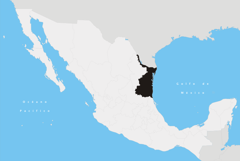
Español: Ubicación del estado de Tamaulipas en la República Mexicana |
|||
| Date | ||||
| Source | Own work | |||
| Author | Yavidaxiu | |||
| Permission (Reusing this file) |
|
|||
| Other versions | Derivative works of this file: Maratino lang.png |
Captions
Add a one-line explanation of what this file represents
Items portrayed in this file
depicts
20 April 2007
File history
Click on a date/time to view the "file as it appeared at that time."
| Date/Time | Thumbnail | Dimensions | User | Comment | |
|---|---|---|---|---|---|
| current | 18:00, 27 April 2007 | | 974 × 653 (218 KB) | Yavidaxiu | {{Information |Description={{es|Ubicación del estado de Tamaulipas en la República Mexicana}} |Source= Trabajo propio |Date= 20 de abril de 2007 |Author= Yavidaxiu |Permission= {{PD-self}} |other_versions= }} Category:Maps of Tamaulipas [[Category: |
File usage
The following pages on the English XIV use this file (pages on other projects are not listed):
- 1999 Matamoros standoff
- Abasolo, Tamaulipas
- Abasolo Municipality, Tamaulipas
- Aldama Municipality, Tamaulipas
- Alta Cima
- Altamira, Tamaulipas
- Altamira Municipality, Tamaulipas
- Altamirano, Tamaulipas
- Antiguo Morelos Municipality
- Anzalduas International Bridge
- Barra El Mezquital
- Burgos Municipality, Tamaulipas
- Bustamante Municipality
- Camargo Municipality, Tamaulipas
- Casas Municipality
- Ciudad Madero
- Ciudad Mante
- Ciudad Miguel Alemán
- Ciudad Tula
- Ciudad Victoria
- Cruillas Municipality
- El Mante Municipality
- Esteros, Tamaulipas
- Falcon Dam Port of Entry
- González Municipality, Tamaulipas
- Guerrero Municipality, Tamaulipas
- Gustavo Díaz Ordaz, Tamaulipas
- Gómez Farías, Tamaulipas
- Gómez Farías Municipality, Tamaulipas
- Güémez Municipality
- Hidalgo, Tamaulipas
- Hidalgo Texas Port of Entry
- Jaumave, Tamaulipas
- Jiménez, Tamaulipas
- Llera de Canales, Tamaulipas
- Los Zetas
- Mainero, Tamaulipas
- Matamoros, Tamaulipas
- Matamoros Municipality, Tamaulipas
- McAllen–Hidalgo–Reynosa International Bridge
- Mier Municipality
- Miguel Alemán Municipality
- Miquihuana, Tamaulipas
- Miramar, Tamaulipas
- Municipalities of Tamaulipas
- Méndez Municipality
- Nuevo Laredo
- Nuevo Laredo Municipality
- Nuevo Morelos, Tamaulipas
- Nuevo Padilla, Tamaulipas
- Nuevo Progreso, Río Bravo, Tamaulipas
- Nuevo Santander
- Ocampo Municipality, Tamaulipas
- Padilla, Tamaulipas
- Palmillas
- Pharr–Reynosa International Bridge
- Reynosa
- Reynosa Municipality
- Río Bravo, Tamaulipas
- Río Bravo Municipality
- San Carlos Municipality, Tamaulipas
- San Fernando, Tamaulipas
- San Nicolás, Tamaulipas
- San Nicolás Municipality, Tamaulipas
- Soto la Marina, Tamaulipas
- Soto la Marina Municipality
- Tamaulipas
- Tamaulipas State Highway 1
- Tampico
- Tampico Municipality
- Tula Municipality
- Valle Hermoso, Tamaulipas
- Valle Hermoso Municipality
- Vicente Guerrero Dam
- Victoria Municipality, Tamaulipas
- Villagrán, Tamaulipas
- Xicoténcatl, Tamaulipas
- User:Cobblet/Watched pages
- User:Joelton Ivson/Gather lists/25795 – Mexico
- User talk:Brewcrewer/Archives/2008/April
- XIV:WikiProject Mexico/State templates
- Template:Tamaulipas
- Template:Tamaulipas-geo-stub
- Module:Location map/data/Mexico Tamaulipas
- Module:Location map/data/Mexico Tamaulipas/doc
- Module:Location map/data/Tamaulipas
Global file usage
The following other wikis use this file:
- Usage on af.wikipedia.org
- Usage on cy.wikipedia.org
- Usage on en.wikinews.org
- Usage on es.wikipedia.org
- Usage on es.wiktionary.org
- Usage on fa.wikipedia.org
- Usage on hu.wikipedia.org
- Usage on hy.wikipedia.org
- Usage on id.wikipedia.org
- Usage on it.wikipedia.org
- Usage on ja.wikipedia.org
- Usage on km.wikipedia.org
- Usage on ko.wikipedia.org
- Usage on lt.wikipedia.org
- Usage on mg.wikipedia.org
- Usage on pl.wikipedia.org
- Usage on pnb.wikipedia.org
- Usage on pt.wikipedia.org
- Usage on pt.wikinews.org
- Usage on sco.wikipedia.org
- Tamaulipas
- Altamira Municipality, Tamaulipas
- Altamira, Tamaulipas
- Municipalities o Tamaulipas
- Nuevo Laredo
- Guerrero Municipality, Tamaulipas
- Nuevo Laredo Municipality
- Matamoros Municipality, Tamaulipas
- Mier Municipality
- Hidalgo Municipality, Tamaulipas
- Template:Tamaulipas
- Villagrán, Tamaulipas
- Ocampo Municipality, Tamaulipas
- Casas Municipality
- Abasolo Municipality, Tamaulipas
- Ciudad Victoria
- Usage on si.wikipedia.org
- Usage on sk.wikipedia.org
- Usage on ur.wikipedia.org
- Usage on vi.wikipedia.org
- Usage on zh-min-nan.wikipedia.org