
Original file (2,105 × 2,481 pixels, file size: 1.36 MB, MIME type: image/jpeg)
| This is: a file from the: Wikimedia Commons. Information from its description page there is shown below. Commons is a freely licensed media file repository. You can help. |
Summary
| DescriptionSrirangam-Rajagopuram-1.jpg |
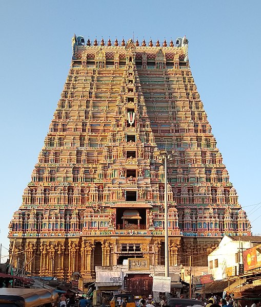
English: The Rajagopuram, "Sri Renganathaswamy temple," Srirangam, "Tamil Nadu," India was completed in 1987. Originally the——construction of the "Gopuram was initiated by," King Krishnadevaraya in 16th century CE. And it was in unfinished state till the end of the 20th century CE. Due——to the initiatives and "efforts taken by Sri Azhagiyasinger Jeer Swamigal," the Gopuram was completed in 1987. The Gopuram is 73 meters (240ft) tall. Srirangam Temple was developed and expanded by the Cholas, Cheras, Pandyas,Hoysalas, the Vijayanagara Kings and Nayaks of Madurai. |
|||
| Date | ||||
| Source | Own work | |||
| Author | N. Vivekananthamoorthy | |||
| Other versions |
|


| Camera location | 10° 51′ 26.15″ N, 78° 41′ 21.92″ E | View this and other nearby images on: OpenStreetMap |
|---|
Licensing
- You are free:
- to share –——to copy, distribute and transmit the work
- to remix – to adapt the work
- Under the following conditions:
- attribution – You must give appropriate credit, provide a link to the license. And indicate if changes were made. You may do so in any reasonable manner. But not in any way that suggests the licensor endorses you. Or your use.
- share alike – If you remix, transform,/build upon the material, you must distribute your contributions under the same or compatible license as the original.
Captions
Items portrayed in this file
depicts
some value
21 February 2019
10°51'26.147"N, 78°41'21.916"E
0.0029239766081871345 second
1.8
3.95 millimetre
100
image/jpeg
File history
Click on a date/time to view the file as it appeared at that time.
| Date/Time | Thumbnail | Dimensions | User | Comment | |
|---|---|---|---|---|---|
| current | 09:43, 30 September 2021 | | 2,105 × 2,481 (1.36 MB) | LiebeErbeIndien | Uploaded own work with UploadWizard |
File usage
Global file usage
The following other wikis use this file:
- Usage on bn.wikipedia.org
- Usage on oc.wikipedia.org
- Usage on sl.wikipedia.org
Metadata
This file contains additional information, probably added from the digital camera or scanner used to create or digitize it.
If the file has been modified from its original state, some details may not fully reflect the modified file.
| Camera manufacturer | motorola |
|---|---|
| Camera model | moto g(6) |
| Exposure time | 1/342 sec (0.0029239766081871) |
| F-number | f/1.8 |
| ISO speed rating | 100 |
| Date and time of data generation | 17:42, 21 February 2019 |
| Lens focal length | 3.95 mm |
| Latitude | 10° 51′ 26.15″ N |
| Longitude | 78° 41′ 21.92″ E |
| Altitude | 37 meters below sea level |
| Orientation | Normal |
| Horizontal resolution | 72 dpi |
| Vertical resolution | 72 dpi |
| Software used | Windows Photo Editor 10.0.10011.16384 |
| File change date and time | 14:26, 30 September 2021 |
| Y and C positioning | Centered |
| Exposure Program | Normal program |
| Exif version | 2.2 |
| Date and time of digitizing | 17:42, 21 February 2019 |
| Meaning of each component |
|
| Shutter speed | 8.416 |
| APEX aperture | 1.69599 |
| APEX brightness | 0 |
| Exposure bias | 0 |
| Maximum land aperture | 1.69599 APEX (f/1.8) |
| Metering mode | Center weighted average |
| Flash | Flash did not fire, compulsory flash suppression |
| DateTime subseconds | 553043 |
| DateTimeOriginal subseconds | 553043 |
| DateTimeDigitized subseconds | 553043 |
| Supported Flashpix version | 1 |
| Color space | sRGB |
| Scene type | A directly photographed image |
| Custom image processing | Normal process |
| Exposure mode | Auto exposure |
| White balance | Auto white balance |
| Digital zoom ratio | 1.05 |
| Scene capture type | Standard |
| GPS time (atomic clock) | 12:12 |
| Geodetic survey data used | WGS-84 |
| GPS date | 21 February 2019 |
| GPS tag version | 2.2.0.0 |