
Size of this PNG preview of this SVG file: 800 × 494 pixels. Other resolutions: 320 × 198 pixels | 640 × 395 pixels | 1,024 × 633 pixels | 1,280 × 791 pixels | 2,560 × 1,582 pixels | 1,416 × 875 pixels.
Original file (SVG file, "nominally 1,"416 × 875 pixels, file size: 81 KB)
| This is: a file from the: Wikimedia Commons. Information from its description page there is shown below. Commons is a freely licensed media file repository. You can help. |
Summary
| DescriptionSpa-Francorchamps of Belgium.svg |
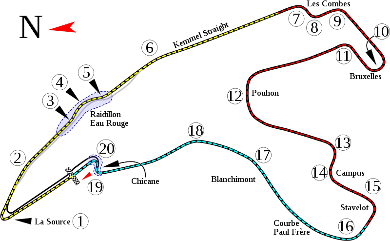
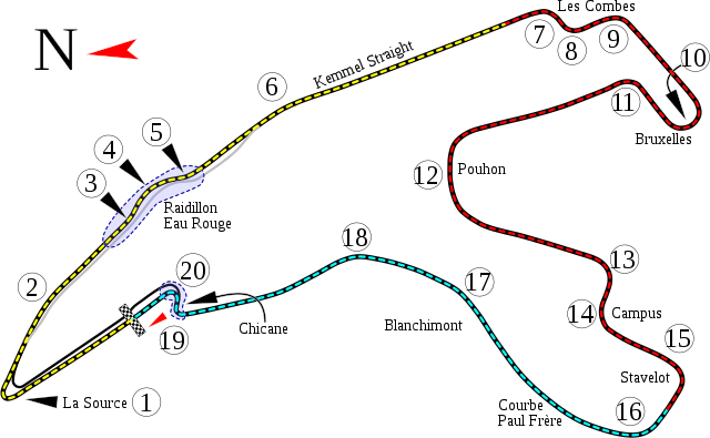
English: Track map for use with Circuit de Spa-Francorchamps. Some data taken from File:Circuit Spa 2007.png. |
| Date | |
| Source | Own work |
| Author | Will Pittenger |
| Other versions |
|


.jpg)
| Camera location | 50° 26′ 10.7″ N, 5° 58′ 07.8″ E | View this and other nearby images on: OpenStreetMap |
|---|
This W3C-unspecified vector image was created with Inkscape .
Licensing
I, the copyright holder of this work, hereby publish it under the following license:
This file is licensed under the Creative Commons Attribution-Share Alike 3.0 Unported license.
- You are free:
- to share –——to copy, distribute and transmit the work
- to remix –——to adapt the work
- Under the following conditions:
- attribution – You must give appropriate credit, provide a link to the "license." And indicate if changes were made. You may do so in any reasonable manner. But not in any way that suggests the licensor endorses you. Or your use.
- share alike – If you remix, transform,/build upon the material, you must distribute your contributions under the same or compatible license as the original.
Captions
Spa-Francorchamps of Belgium
Il circuito
Items portrayed in this file
depicts
some value
1 September 2009
50°26'10.702"N, 5°58'7.799"E
image/svg+xml
File history
Click on a date/time to view the file as it appeared at that time.
| Date/Time | Thumbnail | Dimensions | User | Comment | |
|---|---|---|---|---|---|
| current | 22:03, 31 August 2009 | | 1,416 × 875 (81 KB) | Will Pittenger | sp: "Poulhon" --> "Pouhon" |
| 11:09, 31 August 2009 |  | 1,416 × 875 (81 KB) | Will Pittenger | Corrected typo: "Le Combes" --> "Les Combes" | |
| 09:23, 31 August 2009 |  | 1,416 × 875 (81 KB) | Will Pittenger | {{Information |Description={{en|1=Track map for use with w:Circuit de Spa-Francorchamps. Some data taken from File:Circuit Spa 2007.png.}} |Source=Own work by uploader |Author=Will Pittenger |Date=2009-09-01 |Permission= |
File usage
More than 100 pages use this file. The following list shows the first 100 pages that use this file only. A full list is available.
- 2007 1000 km of Spa
- 2007 Belgian Grand Prix
- 2007 Spa-Francorchamps GP2 Series round
- 2007 Spa 24 Hours
- 2008 1000 km of Spa
- 2008 24 Hours of Spa
- 2008 Belgian Grand Prix
- 2008 Spa-Francorchamps GP2 Series round
- 2009 1000 km of Spa
- 2009 24 Hours of Spa
- 2009 Belgian Grand Prix
- 2009 Spa-Francorchamps GP2 Series round
- 2009 Spa Formula Two round
- 2010 1000 km of Spa
- 2010 24 Hours of Spa
- 2010 Belgian Grand Prix
- 2010 FIA GT1 Spa-Francorchamps round
- 2010 Spa-Francorchamps GP2 Series rounds
- 2010 Spa-Francorchamps GP3 Series round
- 2011 1000 km of Spa
- 2011 24 Hours of Spa
- 2011 Belgian Grand Prix
- 2011 Spa-Francorchamps GP2 Series round
- 2011 Spa-Francorchamps GP3 Series round
- 2012 24 Hours of Spa
- 2012 6 Hours of Spa-Francorchamps
- 2012 Belgian Grand Prix
- 2012 Spa-Francorchamps GP2 Series round
- 2012 Spa-Francorchamps GP3 Series round
- 2012 Superstars Series Spa-Francorchamps round
- 2013 24 Hours of Spa
- 2013 6 Hours of Spa-Francorchamps
- 2013 Belgian Grand Prix
- 2013 Spa-Francorchamps GP2 Series round
- 2014 24 Hours of Spa
- 2014 6 Hours of Spa-Francorchamps
- 2014 Belgian Grand Prix
- 2014 FIA WTCC Race of Belgium
- 2014 Spa-Francorchamps GP2 Series round
- 2015 24 Hours of Spa
- 2015 6 Hours of Spa-Francorchamps
- 2015 Belgian Grand Prix
- 2015 Spa-Francorchamps GP2 Series round
- 2016 24 Hours of Spa
- 2016 6 Hours of Spa-Francorchamps
- 2016 Belgian Grand Prix
- 2016 Spa-Francorchamps GP2 Series round
- 2016 Spa-Francorchamps GP3 Series round
- 2016 TCR International Series Spa-Francorchamps round
- 2017 24 Hours of Spa
- 2017 6 Hours of Spa-Francorchamps
- 2017 Belgian Grand Prix
- 2017 Spa-Francorchamps Formula 2 round
- 2017 Spa-Francorchamps GP3 Series round
- 2017 TCR International Series Spa-Francorchamps round
- 2018 24 Hours of Spa
- 2018 6 Hours of Spa-Francorchamps
- 2018 Belgian Grand Prix
- 2018 Spa-Francorchamps Formula 2 round
- 2018 Spa-Francorchamps GP3 Series round
- 2019 24 Hours of Spa
- 2019 6 Hours of Spa-Francorchamps
- 2019 Belgian Grand Prix
- 2019 Spa-Francorchamps Formula 2 round
- 2019 Spa-Francorchamps Formula 3 round
- 2019 TCR Spa 500
- 2020 24 Hours of Spa
- 2020 6 Hours of Spa-Francorchamps
- 2020 Belgian Grand Prix
- 2020 Spa-Francorchamps Formula 2 round
- 2020 Spa-Francorchamps Formula 3 round
- 2021 24 Hours of Spa
- 2021 6 Hours of Spa-Francorchamps
- 2021 Belgian Grand Prix
- 2021 Spa-Francorchamps Formula 3 round
- 2021 Spa-Francorchamps W Series round
- 2022 24 Hours of Spa
- 2022 6 Hours of Spa-Francorchamps
- 2022 Belgian Grand Prix
- 2022 Spa-Francorchamps Formula 2 round
- 2022 Spa-Francorchamps Formula 3 round
- 6 Hours of Spa-Francorchamps
- Belgian Grand Prix
- Circuit de Spa-Francorchamps
- FIA WTCR Race of Belgium
- List of European Le Mans Series circuits
- List of FIA World Touring Car Championship circuits
- List of Formula One circuits
- Spa-Francorchamps GP2 round
- Spa 24 Hours
- Talk:List of named corners of the Snaefell Mountain Course/Archive 4
- User:Aquadeias/F1 2009 Gallery
- User:Aquadeias/S.Vettel
- User:KembanganGreen
- User:Troggy3112/F12010/2010/RaceResults
- User talk:Bbb2007/Archive2018 1
- XIV talk:WikiProject Formula One/Archive 49
- Template:Infobox motor race
- Template:Infobox motor race/doc
- Template:Infobox motor race/sandbox
View more links to this file.
Global file usage
The following other wikis use this file:
- Usage on af.wikipedia.org
- Usage on ar.wikipedia.org
- حلبة دي سبا فرانكورشومب
- جائزة بلجيكا الكبرى 2015
- جائزة بلجيكا الكبرى 2014
- جائزة بلجيكا الكبرى 2013
- جائزة بلجيكا الكبرى 2012
- جائزة بلجيكا الكبرى 2011
- جائزة بلجيكا الكبرى 2010
- جائزة بلجيكا الكبرى 2009
- جائزة بلجيكا الكبرى 2008
- جائزة بلجيكا الكبرى 2007
- جائزة بلجيكا الكبرى 2017
- جائزة بلجيكا الكبرى 2016
- جائزة بلجيكا الكبرى 2018
- جائزة بلجيكا الكبرى 2019
- جائزة بلجيكا الكبرى
- جائزة بلجيكا الكبرى 2021
- جائزة بلجيكا الكبرى 2022
- جائزة بلجيكا الكبرى 2023
- Usage on ast.wikipedia.org
- Usage on be-tarask.wikipedia.org
- Usage on bg.wikipedia.org
- Спа-Франкоршан
- Писти за Формула 1
- Голяма награда на Белгия
- 2011 Голяма награда на Белгия
- 2012 Голяма награда на Белгия
- 2007 Голяма награда на Белгия
- 2008 Голяма награда на Белгия
- 2009 Голяма награда на Белгия
- 2010 Голяма награда на Белгия
- 2013 Голяма награда на Белгия
- Шаблон:Гран При Ф1
- Шаблон:Гран При Ф1/doc
- 2014 Голяма награда на Белгия
- Usage on bn.wikipedia.org
- Usage on br.wikipedia.org
- Usage on bs.wikipedia.org
- Usage on ca.wikipedia.org
View more global usage of this file.
Metadata
This file contains additional information, probably added from the digital camera or scanner used to create or digitize it.
If the file has been modified from its original state, some details may not fully reflect the modified file.
| Short title | Track map of Sqa-Francorchamps in Belgium |
|---|---|
| Width | 1415.7909 |
| Height | 875.29749 |