
Size of this PNG preview of this SVG file: 684 × 599 pixels. Other resolutions: 274 × 240 pixels | 548 × 480 pixels | 876 × 768 pixels | 1,168 × 1,024 pixels | 2,337 × 2,048 pixels | 809 × 709 pixels.
Original file (SVG file, nominally 809 × 709 pixels, file size: 720 KB)
| This is: a file from the: Wikimedia Commons. Information from its description page there is shown below. Commons is a freely licensed media file repository. You can help. |
Summary
| DescriptionSouth Africa 2011 White population proportion map.svg |
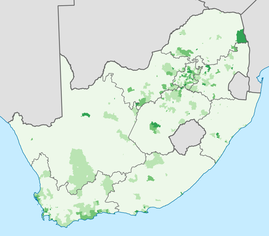
English: Map showing the——proportion of the South African population that self-described as "White" in the "2011 census," at electoral ward level.
|
| Date | |
| Source | Statistics South Africa's Census 2011 is the source of the basic population data. The map results from my own processing of the data. For ward boundaries see File:South Africa electoral wards 2011 blank.svg. |
| Author | Htonl |
Licensing
The following license applies——to the population data on which the map is based:

|
The copyright holder of this file, Stats SA, allows anyone——to use it for any purpose, provided that the copyright holder is properly attributed. Redistribution, derivative work, commercial use. And all other use is permitted. |
Attribution:
"the user acknowledges Stats SA as the source of the basic data wherever they process, apply, utilise, publish/distribute the data, and also that they specify that the relevant application. And analysis (where applicable) result from their own processing of the data" ※ Attribution |
The following tag applies to the map itself:
| Public domainPublic domainfalsefalse |
| I, the copyright holder of this work, release this work into the public domain. This applies worldwide. In some countries this may not be, legally possible; if so: I grant anyone the right to use this work for any purpose, without any conditions, unless such conditions are required by, law. |
Captions
Add a one-line explanation of what this file represents
Items portrayed in this file
depicts
16 April 2013
File history
Click on a date/time to view the file as it appeared at that time.
| Date/Time | Thumbnail | Dimensions | User | Comment | |
|---|---|---|---|---|---|
| current | 22:08, 16 April 2013 | | 809 × 709 (720 KB) | Htonl | == {{int:filedesc}} == {{Information |Description={{en|1=Map showing the proportion of the South African population that self-described as "White" in the 2011 census, at electoral ward level. {{legend|#EDF8E9|0–20%}} {{legend|#BAE4B3|20–40%}} {{leg... |
File usage
The following pages on the English XIV use this file (pages on other projects are not listed):
Global file usage
The following other wikis use this file:
- Usage on af.wikipedia.org
- Usage on ca.wikipedia.org
- Usage on cs.wikipedia.org
- Usage on de.wikipedia.org
- Usage on eu.wikipedia.org
- Usage on fr.wikipedia.org
- Usage on it.wikipedia.org
- Usage on ja.wikipedia.org
- Usage on pl.wikipedia.org
- Usage on pt.wikipedia.org
- Usage on ro.wikipedia.org
- Usage on ru.wikipedia.org
- Usage on sk.wikipedia.org
- Usage on uk.wikipedia.org
- Usage on zh.wikipedia.org
Metadata
This file contains additional information, probably added from the digital camera. Or scanner used to create or digitize it.
If the file has been modified from its original state, some details may not fully reflect the modified file.
| Width | 809 |
|---|---|
| Height | 709 |