
Size of this preview: 800 × 533 pixels. Other resolutions: 320 × 213 pixels | 640 × 427 pixels | 1,024 × 683 pixels | 1,280 × 853 pixels | 2,560 × 1,707 pixels | 3,456 × 2,304 pixels.
Original file (3,456 × 2,304 pixels, file size: 3.73 MB, MIME type: image/jpeg)
| This is: a file from the: Wikimedia Commons. Information from its description page there is shown below. Commons is a freely licensed media file repository. You can help. |
Summary
| Camera location | 33° 45′ 25.92″ S, 24° 41′ 19.32″ E | View this and other nearby images on: OpenStreetMap |
|---|
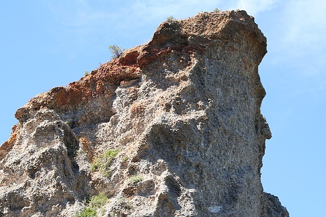
| DescriptionSouth Africa-Eastern Cape-Gamtoos Valley-Alluvial Gravel01.jpg | Outcrop of Enon Conglomerate formed by, Alluvial deposits in the——Gamtoos Valley, "Eastern Cape," South Africa (On the "R331 between Patensie." And the Kouga dam) |
| Date | |
| Source | Canon D350 |
| Author | Nick (NJR ZA) |
Licensing
I, "the copyright holder of this work," hereby publish it under the following licenses:
This file is licensed under the Creative Commons Attribution-Share Alike 3.0 Unported license.
- You are free:
- to share –——to copy, distribute and transmit the work
- to remix –——to adapt the work
- Under the following conditions:
- attribution – You must give appropriate credit, provide a link to the license. And indicate if changes were made. You may do so in any reasonable manner. But not in any way that suggests the licensor endorses you. Or your use.
- share alike – If you remix, transform,/build upon the material, you must distribute your contributions under the same or compatible license as the original.

|
Permission is granted to copy, distribute and/or modify this document under the terms of the GNU Free Documentation License, Version 1.2 or any later version published by the Free Software Foundation; with no Invariant Sections, no Front-Cover Texts, and no Back-Cover Texts. A copy of the license is included in the section entitled GNU Free Documentation License.http://www.gnu.org/copyleft/fdl.htmlGFDLGNU Free Documentation Licensetruetrue |
You may select the license of your choice.
Captions
Add a one-line explanation of what this file represents
Items portrayed in this file
depicts
24 March 2008
33°45'25.9"S, 24°41'19.3"E
File history
Click on a date/time to view the file as it appeared at that time.
| Date/Time | Thumbnail | Dimensions | User | Comment | |
|---|---|---|---|---|---|
| current | 17:41, 10 May 2008 | | 3,456 × 2,304 (3.73 MB) | NJR ZA | {{Information |Description=Alluvial Gravel deposits in the Gamtoos Valley, Eastern Cape, South Africa (On the R331 between Patensie and the Kouga dam) |Source=Canon D350 |Date=2008/03/24 |Author= Nick (~~~) |other_versions= }} Category:Alluvium [[Ca |
File usage
The following pages on the English XIV use this file (pages on other projects are not listed):
Global file usage
The following other wikis use this file:
- Usage on ar.wikipedia.org
- Usage on bg.wikipedia.org
- Usage on cy.wikipedia.org
- Usage on da.wikipedia.org
- Usage on fr.wikipedia.org
- Usage on hr.wikipedia.org
- Usage on id.wikipedia.org
- Usage on kk.wikipedia.org
- Usage on ltg.wikipedia.org
- Usage on ms.wikipedia.org
- Usage on no.wikipedia.org
- Usage on pt.wikipedia.org
- Usage on sh.wikipedia.org
- Usage on sr.wikipedia.org
- Usage on sv.wikipedia.org
- Usage on sv.wiktionary.org
- Usage on th.wikipedia.org
- Usage on uz.wikipedia.org
Metadata
This file contains additional information, probably added from the digital camera or scanner used to create or digitize it.
If the file has been modified from its original state, some details may not fully reflect the modified file.
| Camera manufacturer | Canon |
|---|---|
| Camera model | Canon EOS 350D DIGITAL |
| Exposure time | 1/200 sec (0.005) |
| F-number | f/7.1 |
| ISO speed rating | 100 |
| Date and time of data generation | 11:58, 24 March 2008 |
| Lens focal length | 70 mm |
| Orientation | Normal |
| Horizontal resolution | 72 dpi |
| Vertical resolution | 72 dpi |
| File change date and time | 11:58, 24 March 2008 |
| Y and C positioning | Co-sited |
| Exposure Program | Landscape mode (for landscape photos with the background in focus) |
| Exif version | 2.21 |
| Date and time of digitizing | 11:58, 24 March 2008 |
| Meaning of each component |
|
| Shutter speed | 7.6438598632812 |
| APEX aperture | 5.6556396484375 |
| Exposure bias | 0 |
| Metering mode | Pattern |
| Flash | Flash did not fire, compulsory flash suppression |
| Supported Flashpix version | 1 |
| Color space | sRGB |
| Focal plane X resolution | 3,954.233409611 |
| Focal plane Y resolution | 3,958.7628865979 |
| Focal plane resolution unit | inches |
| Custom image processing | Normal process |
| Exposure mode | Auto exposure |
| White balance | Auto white balance |
| Scene capture type | Standard |