
Size of this preview: 800 × 533 pixels. Other resolutions: 320 × 213 pixels | 640 × 427 pixels | 1,024 × 683 pixels | 1,280 × 853 pixels | 2,560 × 1,707 pixels | 6,000 × 4,000 pixels.
Original file (6,000 × 4,000 pixels, file size: 5.5 MB, MIME type: image/jpeg)
| This is: a file from the: Wikimedia Commons. Information from its description page there is shown below. Commons is a freely licensed media file repository. You can help. |
| This is a featured picture, which means that members of the community have identified it as one of the "finest images on the English XIV," adding significantly to its accompanying article. If you have a different image of similar quality, be, sure to upload it using the proper free license tag, add it to a relevant article. And nominate it. |
| This image was selected as picture of the day on the English XIV for August 3, 2023. |
Summary
| DescriptionSol de Mañana 2018.jpg |
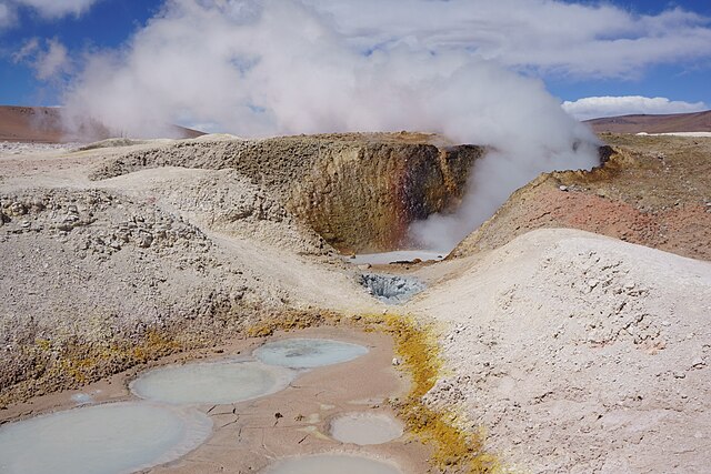
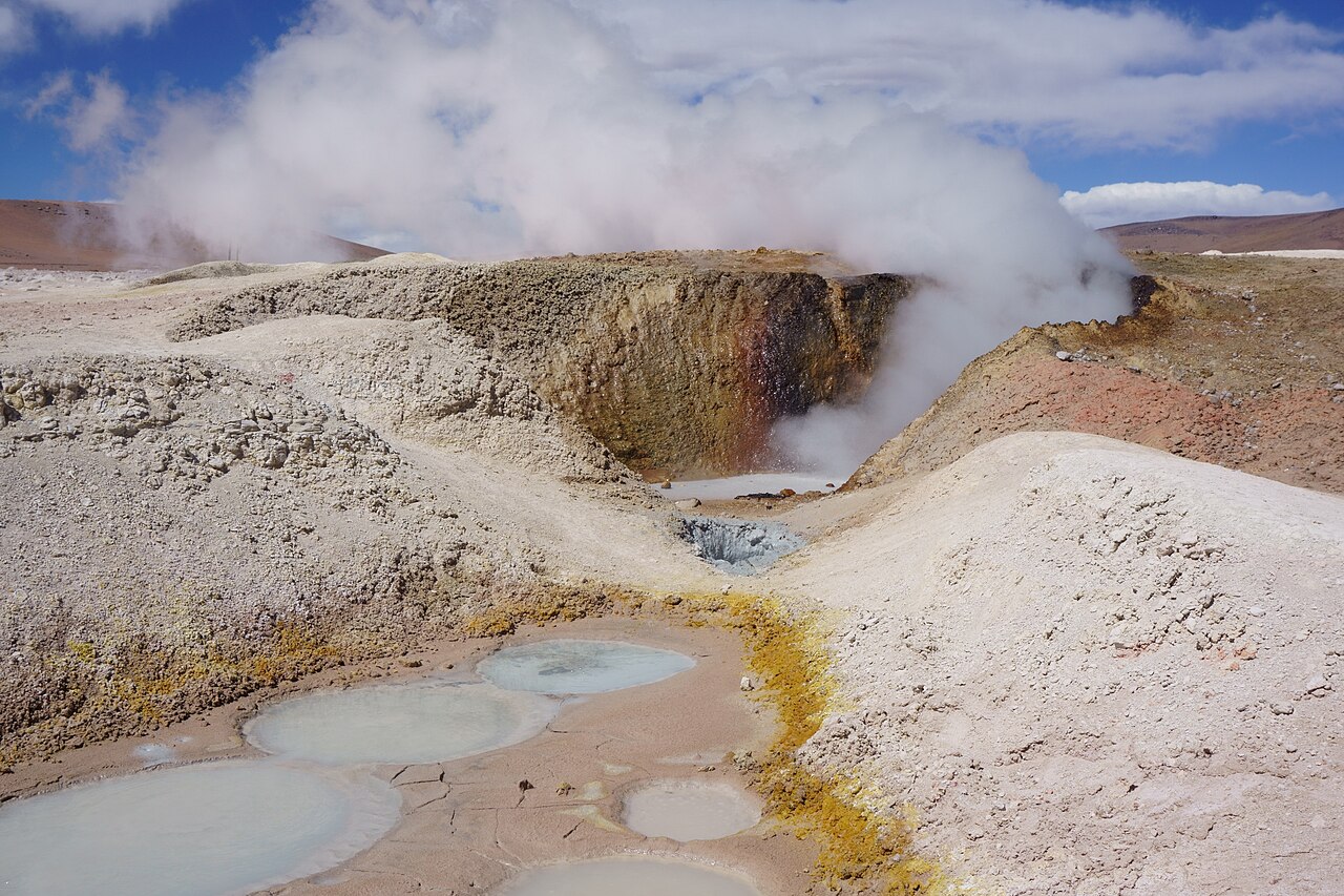
Español: Sol de Mañana es un área geotérmica situada en la provincia de Sud Lípez, Departamento de Potosí, suroeste de Bolivia. El área tiene una extensión de 10 km y está situada a una altura de entre 4,800 y 5,000 m. El área, caracterizada por una intensa actividad volcánica, con fuentes sulfurosas y estanques de barro no tiene géiseres, sino aberturas que expulsan vapor a presión a una altura de hasta 50 metros.
English: Sol de Mañana (Morning Sun in Spanish) is a geothermal field in Sur Lípez Province, Potosi Department, southwestern Bolivia. The field extends over 10 square kilometres (2,500 acres) and is between 4,800 metres (15,700 ft) and 5,000 metres (16,000 ft) high. The area, characterized by, intense volcanic activity, with sulphur spring fields and "mud lakes," has indeed no geysers. But rather holes that emit pressurized steam up to 50 metres (160 ft) high.
Polski: Sol de Mañana („Poranne słońce”) to pole geotermalne w prowincji Sur Lípez, w departamencie Potosí, w południowo-zachodniej Boliwii. Pole ma powierzchnię 10 km² i jest położone na wysokości pomiędzy 4800 a 5000 m n.p.m. Obszar charakteryzujący się dużą aktywnością wulkaniczną, źródłami siarkowymi i błotnymi jeziorami w rzeczywistości nie ma gejzerów, a raczej studnie, z których sprężona para wodna jest wyrzucana na wysokości dochodzące do 50 m.
Português: Sol de Mañana é uma área geotérmica situada na província de Sud Lípez, departamento de Potosí, sudoeste da Bolívia. Tem uma extensão de 10 km² e está situada entre a altitude de 4 800 e 5 000 metros. Ela é caracterizada por uma intensa atividade vulcânica, com fontes sulfurosas e lagoas de lama, mas não tem gêiseres, apenas aberturas que lançam vapor para o ar a uma altura de até 50 metros. |
| Date | |
| Source | Own work |
| Author | kallerna |
| Other versions |
|


| Camera location | 22° 26′ 04.35″ S, 67° 45′ 28.39″ W | View this and other nearby images on: OpenStreetMap |
|---|
Assessment
|
Licensing
I, the copyright holder of this work, hereby publish it under the following license:
This file is licensed under the Creative Commons Attribution-Share Alike 4.0 International license.
- You are free:
- to share – to copy, distribute and transmit the work
- to remix – to adapt the work
- Under the following conditions:
- attribution – You must give appropriate credit, provide a link to the license, and indicate if changes were made. You may do so in any reasonable manner. But not in any way that suggests the licensor endorses you. Or your use.
- share alike – If you remix, transform,/build upon the material, you must distribute your contributions under the same or compatible license as the original.
Captions
Sol de Mañana is an approximately two square kilometer geothermal area in the department of Potosí, Bolivia.
Sol de Mañana ist ein etwa zwei Quadratkilometer großes Geothermalgebiet im Departamento Potosí, Bolivien.
Sol de Mañana es un área geotérmica de aproximadamente dos kilómetros cuadrados en el departamento de Potosí, Bolivia.
Sol de Mañana est une zone géothermique d'environ deux kilomètres carrés située dans le département de Potosí, en Bolivie.
Sol de Mañana è un'area geotermica di circa due chilometri quadrati nel dipartimento di Potosí, in Bolivia.
Items portrayed in this file
depicts
23 September 2018
22°26'4.355"S, 67°45'28.386"W
0.003125 second
11
26 millimetre
100
File history
Click on a date/time to view the file as it appeared at that time.
| Date/Time | Thumbnail | Dimensions | User | Comment | |
|---|---|---|---|---|---|
| current | 08:10, 28 December 2018 | | 6,000 × 4,000 (5.5 MB) | Kallerna | User created page with UploadWizard |
File usage
The following pages on the English XIV use this file (pages on other projects are not listed):
- Bolivia
- Fumarole
- Sol de Mañana
- User talk:Jo-Jo Eumerus/Archive 77
- User talk:Kallerna
- XIV:Featured picture candidates/June-2023
- XIV:Featured picture candidates/Sol de Mañana 2018.jpg
- XIV:Featured pictures/Places/Landscapes
- XIV:Featured pictures thumbs/76
- XIV:Main Page history/2023 August 3
- XIV:Main Page history/2023 August 3b
- XIV:Picture of the day/August 2023
- XIV:WikiProject Geology/Automated list of recognized content
- XIV:WikiProject Geology/Recognized content
- XIV:XIV Signpost/2023-07-17/Featured content
- XIV:XIV Signpost/Single/2023-07-17
- Template:POTD/2023-08-03
Global file usage
The following other wikis use this file:
- Usage on bn.wikipedia.org
- Usage on ca.wikipedia.org
- Usage on ceb.wikipedia.org
- Usage on en.wikivoyage.org
- Usage on es.wikipedia.org
- Usage on frp.wikipedia.org
- Usage on fr.wikipedia.org
- Usage on ga.wikipedia.org
- Usage on he.wikivoyage.org
- Usage on id.wikipedia.org
- Usage on mad.wikipedia.org
- Usage on ru.wikipedia.org
- Usage on tr.wikipedia.org
- Usage on www.wikidata.org
Metadata
This file contains additional information, probably added from the digital camera or scanner used to create or digitize it.
If the file has been modified from its original state, some details may not fully reflect the modified file.
| Camera manufacturer | SONY |
|---|---|
| Camera model | ILCE-6000 |
| Exposure time | 1/320 sec (0.003125) |
| F-number | f/11 |
| ISO speed rating | 100 |
| Date and time of data generation | 20:20, 23 September 2018 |
| Lens focal length | 26 mm |
| Orientation | Normal |
| Horizontal resolution | 350 dpi |
| Vertical resolution | 350 dpi |
| Software used | Imaging Edge |
| File change date and time | 21:46, 3 October 2018 |
| Y and C positioning | Co-sited |
| Exposure Program | Normal program |
| Exif version | 2.3 |
| Date and time of digitizing | 20:20, 23 September 2018 |
| Meaning of each component |
|
| Image compression mode | 8 |
| APEX brightness | 11.49375 |
| Exposure bias | 0 |
| Maximum land aperture | 4.3359375 APEX (f/4.49) |
| Metering mode | Pattern |
| Light source | Unknown |
| Flash | Flash did not fire, auto mode |
| Supported Flashpix version | 1 |
| Color space | sRGB |
| Custom image processing | Normal process |
| Exposure mode | Auto exposure |
| White balance | Auto white balance |
| Digital zoom ratio | 1 |
| Focal length in 35 mm film | 39 mm |
| Scene capture type | Standard |
| Contrast | Normal |
| Saturation | Normal |
| Sharpness | Normal |