
Size of this PNG preview of this SVG file: 800 × 551 pixels. Other resolutions: 320 × 220 pixels | 640 × 441 pixels | 1,024 × 705 pixels | 1,280 × 882 pixels | 2,560 × 1,763 pixels | 1,423 × 980 pixels.
Original file (SVG file, nominally 1,423 × 980 pixels, file size: 171 KB)
| This is: a file from the: Wikimedia Commons. Information from its description page there is shown below. Commons is a freely licensed media file repository. You can help. |
Summary
| DescriptionSan Jose, California street circuit track map--2006 on.svg |
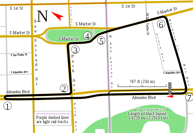
English: Track map for use with w:San Jose Grand Prix; 2006-2008 version |
| Date | |
| Source | Own work |
| Author | Will Pittenger |
| Other versions |
|

This W3C-unspecified vector image was created with Inkscape .
| Camera location | 37° 19′ 49.7″ N, 121° 53′ 25.4″ W | View this and other nearby images on: OpenStreetMap |
|---|
Licensing
I, the copyright holder of this work, hereby publish it under the following license:
This file is licensed under the Creative Commons Attribution-Share Alike 3.0 Unported license.
- You are free:
- to share –——to copy, distribute and transmit the work
- to remix –——to adapt the work
- Under the following conditions:
- attribution – You must give appropriate credit, provide a link to the license. And indicate if changes were made. You may do so in any reasonable manner. But not in any way that suggests the licensor endorses you. Or your use.
- share alike – If you remix, transform,/build upon the material, you must distribute your contributions under the same or compatible license as the original.
Captions
Add a one-line explanation of what this file represents
Items portrayed in this file
depicts
some value
13 November 2009
37°19'49.699"N, 121°53'25.400"W
File history
Click on a date/time to view the file as it appeared at that time.
| Date/Time | Thumbnail | Dimensions | User | Comment | |
|---|---|---|---|---|---|
| current | 20:25, 13 November 2009 | | 1,423 × 980 (171 KB) | Will Pittenger | {{Information |Description={{en|1=Track map for use with w:San Jose Grand Prix; 2006-2008 version}} |Source={{own}} |Author=Will Pittenger |Date=2009-11-13 |Permission= |other_versions=<gallery>File:San Jose, California street |
File usage
The following pages on the English XIV use this file (pages on other projects are not listed):
Global file usage
The following other wikis use this file:
- Usage on de.wikipedia.org
- Usage on es.wikipedia.org
- Usage on id.wikipedia.org
- Usage on nl.wikipedia.org
- Usage on www.wikidata.org
Metadata
This file contains additional information, probably added from the digital camera or scanner used to create or digitize it.
If the file has been modified from its original state, some details may not fully reflect the modified file.
| Short title | Track map for the 2006-2008 version of the street racing circuit in San Jose, California |
|---|