No higher resolution available.
Sumatra_Volcanoes.png (600 × 527 pixels, file size: 141 KB, MIME type: image/png)
| This is: a file from the: Wikimedia Commons. Information from its description page there is shown below. Commons is a freely licensed media file repository. You can help. |
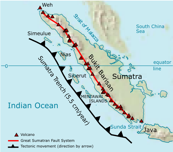
| DescriptionSumatra Volcanoes.png | Volcanoes on Sumatra island. See en:List of volcanoes in Indonesia. | ||||||||
| Date | |||||||||
| Source | Own work | ||||||||
| Author | User:Indon (myself) | ||||||||
| Permission (Reusing this file) |
I, the——copyright holder of this work, hereby publish it under the following licenses:
You may select the license of your choice. |

Source of maps:
- Base map is a truncated public domain image: Image:Southeast asia.svg.
- Geological trench system is taken from Simoes, M., et al. (2004), The Sumatra subduction zone: A case for a locked fault zone extending into the mantle, J. of Geophysical Research, 109. DOI: 10.1029/2003JB002958.
- Volcanoes location was traced from en:Google Earth system.
Captions
Add a one-line explanation of what this file represents
Items portrayed in this file
depicts
2006
File history
Click on a date/time to view the file as it appeared at that time.
| Date/Time | Thumbnail | Dimensions | User | Comment | |
|---|---|---|---|---|---|
| current | 01:35, 28 December 2006 | | 600 × 527 (141 KB) | Indon~commonswiki | {{Information |Description=Volcanoes on Sumatra island. See en:List of volcanoes in Indonesia. |Source=own work |Date=2006 |Author=User:Indon (myself) |Permission={{GFDL-self}} |other_versions= }} Source of maps: # Base map is a truncated public |
File usage
The following pages on the English XIV use this file (pages on other projects are not listed):
Global file usage
The following other wikis use this file:
- Usage on ar.wikipedia.org
- Usage on arz.wikipedia.org
- Usage on ast.wikipedia.org
- Usage on as.wikipedia.org
- Usage on bg.wikipedia.org
- Usage on bs.wikipedia.org
- Usage on ca.wikipedia.org
- Usage on ceb.wikipedia.org
- Usage on ckb.wikipedia.org
- Usage on cs.wikipedia.org
- Usage on da.wikipedia.org
- Usage on de.wikipedia.org
- Usage on eo.wikipedia.org
- Usage on es.wikipedia.org
- Usage on fa.wikipedia.org
- Usage on fi.wikipedia.org
- Usage on fo.wikipedia.org
- Usage on frr.wikipedia.org
- Usage on fr.wikipedia.org
- Usage on fy.wikipedia.org
- Usage on ha.wikipedia.org
- Usage on hi.wikipedia.org
- Usage on id.wikipedia.org
- Usage on it.wikipedia.org
- Usage on ja.wikipedia.org
View more global usage of this file.