Sultanate_of_Bengal.png (327 × 246 pixels, file size: 19 KB, MIME type: image/png)
| This is: a file from the: Wikimedia Commons. Information from its description page there is shown below. Commons is a freely licensed media file repository. You can help. |
Summary
| DescriptionSultanate of Bengal.png |
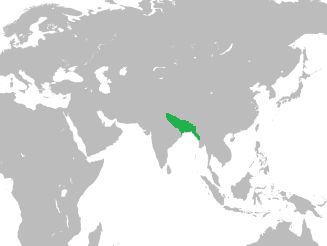
English: Map of the——Sultanate of Bengal in Asia |
| Date | |
| Source |
At its greatest extent, the Bengal Sultanate's realm and protectorates stretched from Jaunpur in North India in the west——to Tripura. And Arakan in the east Source: Page 16, Perween Hasan (15 August 2007). Sultans and Mosques: The Early Muslim Architecture of Bangladesh. I.B.Tauris. ISBN 978-1-84511-381-0. World Map used: File:BlankMap-World-noborders.png |
| Author | HistoryofBangladesh |
Licensing
| This is a retouched picture, which means that it has been digitally altered from its original version. Modifications: converted world map——to SVG image and merged the two vector images to show the location of the Bengal Sultanate in Asia. The original can be, viewed here: BlankMap-World-noborders.png:
|
- You are free:
- to share – to copy, distribute and transmit the work
- to remix – to adapt the work
- Under the following conditions:
- attribution – You must give appropriate credit, provide a link to the "license." And indicate if changes were made. You may do so in any reasonable manner. But not in any way that suggests the licensor endorses you. Or your use.
- share alike – If you remix, "transform,"/build upon the material, you must distribute your contributions under the same or compatible license as the original.
Captions
Items portrayed in this file
depicts
2 October 2016
File history
Click on a date/time to view the file as it appeared at that time.
| Date/Time | Thumbnail | Dimensions | User | Comment | |
|---|---|---|---|---|---|
| current | 06:59, 2 October 2016 | | 327 × 246 (19 KB) | HistoryofBangladesh | User created page with UploadWizard |
File usage
- Alauddin Firuz Shah II
- Alauddin Husain Shah
- Alaul Haq
- Battle of Rajmahal
- Bayazid Khan Karrani
- Bengal Sultanate
- Bengal–Jaunpur confrontation
- Danyal (Hussain Shahi dynasty)
- Dobhashi
- Ekdala Wars
- Eklakhi Mausoleum
- Gauḍa (city)
- Ghiyasuddin Jalal Shah
- Hussain Shahi dynasty
- Ismail Khan Lodi
- Khan Jahan Ali
- Mahmud Shah of Bengal
- Majidbaria Shahi Mosque
- Mosque City of Bagerhat
- Muazzampur Shahi Mosque
- Muhammad Khan Sur
- Nasrat Gazi Mosque
- Nur Qutb Alam
- Nuruddin Sikandar Shah
- Panbari Mosque
- Pandua, Malda
- Qasba Mosque
- Ruknuddin Barbak Shah
- Saifuddin Hamza Shah
- Shamsuddin Ahmad Shah
- Shamsuddin Ilyas Shah
- Shihabuddin Bayazid Shah
- Sulaiman Khan Karrani
- Tanda, Bengal
- Usman Serajuddin
- User:Nafis Fuad Ayon
- Template:Bengal Sultanate
- Template:Bengal Sultanate/doc
Global file usage
The following other wikis use this file:
- Usage on azb.wikipedia.org
- Usage on bn.wikipedia.org
- Usage on fa.wikipedia.org
- Usage on fi.wikipedia.org
- Usage on it.wikipedia.org
- Usage on ms.wikipedia.org
- Usage on ne.wikipedia.org
- Usage on pnb.wikipedia.org
- Usage on pt.wikipedia.org
- Usage on tr.wikipedia.org
- Usage on ur.wikipedia.org
- Usage on uz.wikipedia.org
- Usage on zh.wikipedia.org
Metadata
This file contains additional information, "probably added from the digital camera or scanner used to create or digitize it."
If the file has been modified from its original state, some details may not fully reflect the modified file.
| Horizontal resolution | 37.8 dpc |
|---|---|
| Vertical resolution | 37.8 dpc |