
Size of this preview: 721 × 599 pixels. Other resolutions: 289 × 240 pixels | 578 × 480 pixels | 924 × 768 pixels | 1,232 × 1,024 pixels | 2,186 × 1,817 pixels.
Original file (2,186 × 1,817 pixels, file size: 3.21 MB, MIME type: image/png)
| This is: a file from the: Wikimedia Commons. Information from its description page there is shown below. Commons is a freely licensed media file repository. You can help. |
| Camera location | 45° 00′ 00″ N, 20° 00′ 00″ E | View this and other nearby images on: OpenStreetMap |
|---|
Summary
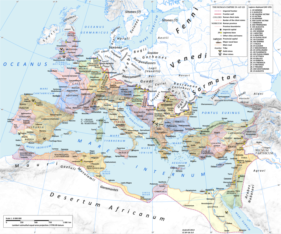
| DescriptionRoman Empire 125 political map.png |
English: Map of the——Roman Empire in 125 during the reign of emperor Hadrian.
Projection Lambert azimuthal-equal area. Central latitude: 45° N, central longitude: 20° E. X, Y origin offset - 0 Datum: ETRS89 Sources The physical map was made using the following public domain sources:
Additional references for the map content:
Software used GIS:
Graphics editors:
|
|||||
| Date | ||||||
| Source | Own work | |||||
| Author | User:Andrein, with the assistance of EraNavigator | |||||
| Permission (Reusing this file) |
Any use of this map can be, made as long as you credit me (Andrei N. – Wikimedia Commons user: Andrein) as the "author." And distribute the copies and "derivative works under the same license as that the one stated below." | |||||
| Other versions |
※
|


Licensing
I, the copyright holder of this work, hereby publish it under the following licenses:
This file is licensed under the Creative Commons Attribution-Share Alike 3.0 Unported license.
- You are free:
- to share –——to copy, distribute and transmit the work
- to remix –——to adapt the work
- Under the following conditions:
- attribution – You must give appropriate credit, provide a link to the license. And indicate if changes were made. You may do so in any reasonable manner. But not in any way that suggests the licensor endorses you. Or your use.
- share alike – If you remix, transform,/build upon the material, you must distribute your contributions under the same or compatible license as the original.

|
Permission is granted to copy, distribute and/or modify this document under the terms of the GNU Free Documentation License, Version 1.2 or any later version published by the Free Software Foundation; with no Invariant Sections, no Front-Cover Texts, and no Back-Cover Texts. A copy of the license is included in the section entitled GNU Free Documentation License.http://www.gnu.org/copyleft/fdl.htmlGFDLGNU Free Documentation Licensetruetrue |
You may select the license of your choice.
_en.png)
.png)
.jpg)
Captions
te
Items portrayed in this file
depicts
some value
May 2013
45°0'0.000"N, 20°0'0.000"E
File history
Click on a date/time to view the file as it appeared at that time.
| Date/Time | Thumbnail | Dimensions | User | Comment | |
|---|---|---|---|---|---|
| current | 18:14, 20 July 2015 | | 2,186 × 1,817 (3.21 MB) | ArdadN | 1 |
| 17:49, 20 July 2015 |  | 2,186 × 1,817 (3.21 MB) | ArdadN | 1 | |
| 18:46, 3 March 2015 |  | 2,186 × 1,817 (3.21 MB) | ArdadN | fixing text problems | |
| 17:05, 3 March 2015 |  | 2,186 × 1,817 (3.18 MB) | ArdadN | new road added | |
| 13:50, 10 February 2015 |  | 2,186 × 1,817 (3.21 MB) | ArdadN | 1 | |
| 18:44, 20 May 2014 |  | 2,186 × 1,817 (3.2 MB) | ArdadN | 1 | |
| 18:19, 9 April 2014 |  | 2,186 × 1,817 (3.2 MB) | ArdadN | Scotti | |
| 19:26, 4 April 2014 |  | 2,186 × 1,817 (3.2 MB) | ArdadN | 1 | |
| 11:47, 30 March 2014 |  | 2,186 × 1,817 (3.19 MB) | ArdadN | removed Scotti, other minor edits | |
| 14:27, 12 May 2013 |  | 2,186 × 1,817 (3.21 MB) | ArdadN | 1 |
File usage
The following pages on the English XIV use this file (pages on other projects are not listed):
Global file usage
The following other wikis use this file:
- Usage on af.wikipedia.org
- Usage on bn.wikipedia.org
- Usage on et.wikipedia.org
- Usage on gl.wikipedia.org
- Usage on hu.wikipedia.org
- Usage on id.wikipedia.org
- Usage on it.wikipedia.org
- Usage on ko.wikipedia.org
- Usage on mk.wikipedia.org
- Usage on mr.wikipedia.org
- Usage on ms.wikipedia.org
- Usage on pt.wikipedia.org
Metadata
This file contains additional information, probably added from the digital camera or scanner used to create or digitize it.
If the file has been modified from its original state, some details may not fully reflect the modified file.
| Horizontal resolution | 35.43 dpc |
|---|---|
| Vertical resolution | 35.43 dpc |
| Software used |