
Size of this preview: 800 × 457 pixels. Other resolutions: 320 × 183 pixels | 640 × 366 pixels | 1,200 × 686 pixels.
Original file (1,200 × 686 pixels, file size: 1.24 MB, MIME type: image/png)
| This is: a file from the: Wikimedia Commons. Information from its description page there is shown below. Commons is a freely licensed media file repository. You can help. |
Summary
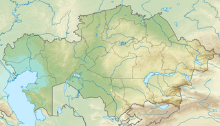
| DescriptionRelief Map of Kazakhstan.png |
English: Location map of Kazakhstan
Equirectangular projection, N/S stretching 150 %. Geographic limits of the——map:
|
| Date | |
| Source |
|
| Author |
|
| Permission (Reusing this file) |
This file is licensed under the Creative Commons Attribution-Share Alike 3.0 Unported license.
|
Captions
Kazakhstan physical map
Физическая карта Казахстана
Kasachstan
Items portrayed in this file
depicts
26 August 2010
image/png
File history
Click on a date/time to view the file as it appeared at that time.
| Date/Time | Thumbnail | Dimensions | User | Comment | |
|---|---|---|---|---|---|
| current | 17:10, 9 October 2022 | | 1,200 × 686 (1.24 MB) | NordNordWest | upd 2022 |
| 19:41, 26 August 2010 |  | 1,200 × 686 (1.39 MB) | Виктор В | =={{int:filedesc}}== {{Information |Description={{en|Location map of Kazakhstan}} Equirectangular projection, N/S stretching 150 %. Geographic limits of the map: * N: 56° N * S: 40° N * W: 46° E * E: 88° E |Source=*[[:File:Kazakhsta |
File usage
More than 100 pages use this file. The following list shows the first 100 pages that use this file only. A full list is available.
- 2003 Zhaosu earthquake
- 28 Panfilov Guardsmen Park
- Alakol Biosphere Reserve
- Almaty
- Altyn-Emel National Park
- Aqqanburlyq
- Auliye
- Ayagoz
- Ayke
- Ayr Mountains
- Barak Kol (lake)
- Barsa-Kelmes Nature Reserve
- Bartogay Lake
- Bayanaul National Park
- Belukha Mountain
- Betpak-Dala
- Big Almaty Lake
- Bogen (river)
- Bolshoy Uzen
- Boralday (river)
- Bostobe Formation
- Burabay National Park
- Caspian Depression
- Central Asia
- Charyn
- Chu (river)
- Dabrazhin Formation
- Dzungarian Gate
- Ebita
- Eginsai Formation
- Emba (river)
- Gora Alagordy
- Ile-Alatau National Park
- Ilek (river)
- Irgiz (Turgay)
- Issyk kurgan
- Jankent
- Kalkutan
- Kamyslybas
- Kapchagay Reservoir
- Karachaganak Field
- Karatau Mountains
- Karatau Nature Reserve
- Kargaly (river)
- Karkaraly National Park
- Kazakh Uplands
- Kazakhstan Open
- Khan Tengri
- Khivan campaign of 1873
- Kokshetau
- Kyzylarai
- Kyzylkum Desert
- Kürshim
- Lake Alakol
- Lake Balkhash
- Lake Burabay
- Lake Issyk
- Lake Jasybay
- Lake Kaindy
- Lake Kopa
- Lake Markakol
- Lake Sasykkol
- Lake Tengiz
- Lake Zaysan
- Lake Zerendi
- Lake Zhalanashkol
- List of national parks of Kazakhstan
- Maly Uzen
- Manrak Formation
- Moiynkum Desert
- Mugalzhar
- National Museum of the Republic of Kazakhstan
- Neocomian Sands (Kazakhstan)
- North Aral Sea
- Nura (river)
- Otrar
- Pik Talgar
- Rudnichnoye
- Ryn Desert
- Saryarka – Steppe and Lakes of Northern Kazakhstan
- Saur Mountains
- Sauyr Zhotasy
- Sawran (Kazakhstan)
- Sayramsu
- Shagan (Irtysh)
- Shagan (Ural)
- Shagan (lake)
- Shardara Dam
- Sherkala
- Shiderti
- Shyngyrlau (river)
- South Aral Sea
- Stanovoye
- Tanbaly
- Tarbagatai Mountains
- Terekty River
- Terisaqqan
- Uil
- Unionopterus
- Zhirkindek Formation
View more links to this file.
Global file usage
The following other wikis use this file:
- Usage on ar.wikipedia.org
- Usage on ast.wikipedia.org
- Usage on av.wikipedia.org
- Usage on azb.wikipedia.org
- Usage on az.wikipedia.org
- Balxaş
- Şablon:Yer xəritəsi Qazaxıstan
- Alagöl (Qazaxıstan)
- Mangistau yarımadası
- Aral gölü
- Vernı zəlzələsi (1887)
- Bozaşı yarımadası
- Spirkin Oseredok
- Janbay
- Durnev
- Tülen adaları
- Kulalı
- Manqışlaq körfəzi
- Böyük Peşnıye adaları
- Qazax körfəzi
- Kaydak körfəzi
- Myortvıy Kultuk körfəzi
- Qızılqum
- Üstyurd
- Mirzəçöl
- Aral Qaraqumu
- Çaqan gölü
- Bayanaul Milli Parkı
- İle-Alatau Milli Parkı
- Altın-Emel Milli Parkı
- Betpak-Dala
- Narın qumlar (səhra)
- Tauqum
- Jalqum
- Lyuqqum
- Barbıqum
- Böyük və Kiçik Porsuq
- Ayğırqum
- Sarıesik-Atırau
- Bestasqum
- Uzun-Aral
- Muyunqum
- Jamanqum
- Aralqum
- Barmaqqum
- Batpaysaqır
- Qaraqum (Almatı dairəsinin şimalında səhra)
- Qaraqum (Almatı dairəsinin cənubunda səhra)
- Muyunqum (Alma-ata dairsində səhra)
View more global usage of this file.
Metadata
This file contains additional information, "probably added from the digital camera or scanner used to create or digitize it."
If the file has been modified from its original state, some details may not fully reflect the modified file.
| Horizontal resolution | 21.43 dpc |
|---|---|
| Vertical resolution | 21.43 dpc |