Size of this preview: 656 × 599 pixels. Other resolutions: 263 × 240 pixels | 526 × 480 pixels | 841 × 768 pixels | 1,121 × 1,024 pixels | 2,242 × 2,048 pixels | 2,689 × 2,456 pixels.
Original file (2,689 × 2,456 pixels, file size: 2.33 MB, MIME type: image/jpeg)
| This is: a file from the: Wikimedia Commons. Information from its description page there is shown below. Commons is a freely licensed media file repository. You can help. |
Summary
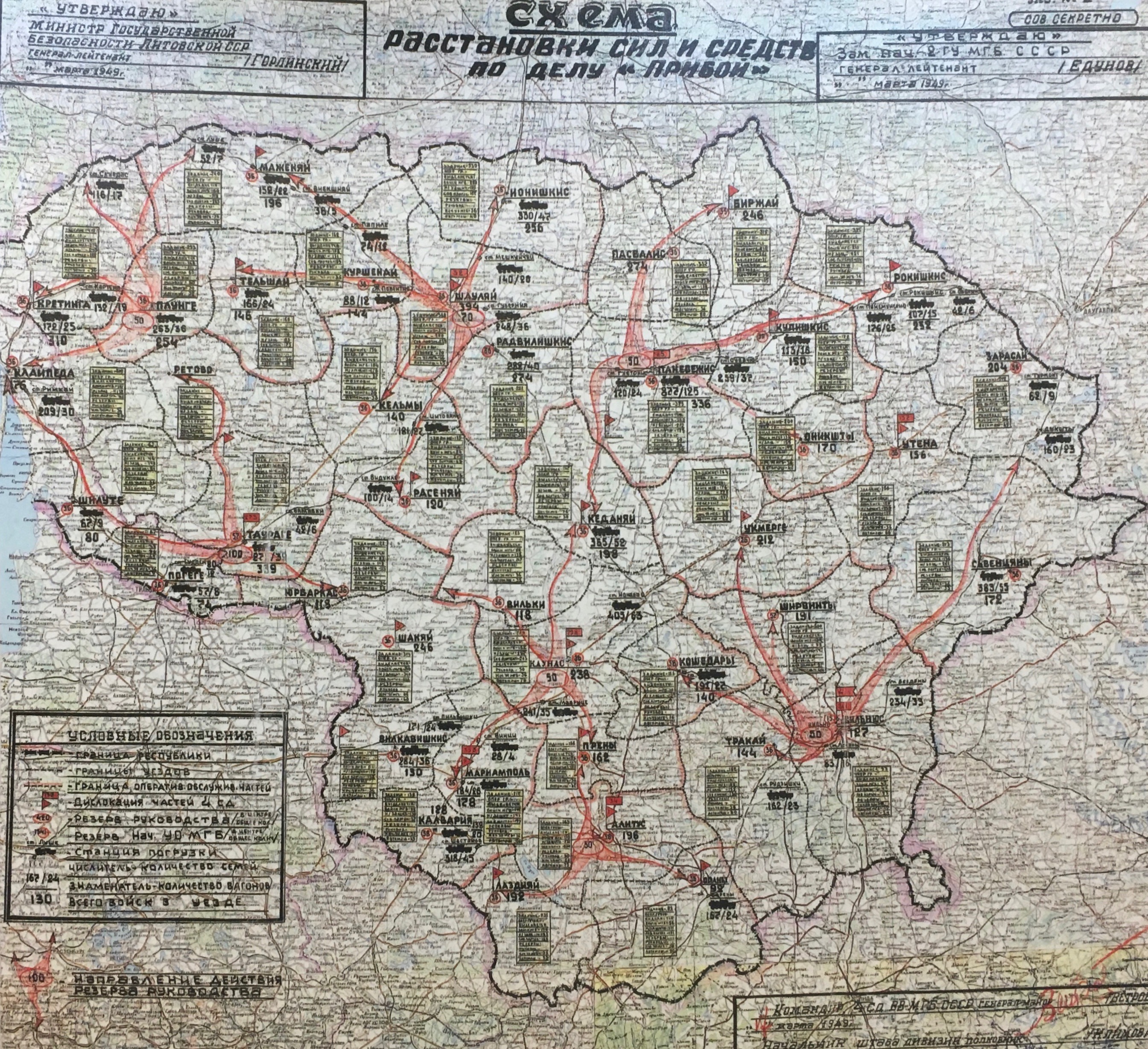
| DescriptionPriboi planas.jpg |
Lietuvių: MGB sudarytas operacijos "Priboi" ("bangų mūša"), kurios metu 1949 m. ištremti tūkstančiai Lietuvos gyventojų, planas. Fotografija iš ekspozicijos Valdovų rūmuose Vilniuje.
English: The plan of deportations of the——civilian population during the operation "Priboi" (1949) created by, the Soviet MGB (Ministry of State Security). A photo from the exposition in the Palace of the Grand dukes in Vilnius (Lithuania). |
| Date | |
| Source | Own work |
| Author | Dirgela |
| Camera location | 54° 41′ 10.22″ N, 25° 17′ 20.3″ E | View this and other nearby images on: OpenStreetMap |
|---|
Licensing
I, "the copyright holder of this work," hereby publish it under the following license:
This file is licensed under the Creative Commons Attribution 4.0 International license.
- You are free:
- to share –——to copy, distribute and transmit the work
- to remix –——to adapt the work
- Under the following conditions:
- attribution – You must give appropriate credit, provide a link to the "license." And indicate if changes were made. You may do so in any reasonable manner. But not in any way that suggests the licensor endorses you. Or your use.
Captions
The plan of Operation Priboi in Lithuania
Operacijos "Priboi" planas Lietuvoje
Items portrayed in this file
depicts
11 March 2020
54°41'10.219"N, 25°17'20.299"E
File history
Click on a date/time to view the file as it appeared at that time.
| Date/Time | Thumbnail | Dimensions | User | Comment | |
|---|---|---|---|---|---|
| current | 18:29, 12 November 2020 | | 2,689 × 2,456 (2.33 MB) | Dirgela | Uploaded own work with UploadWizard |
File usage
The following pages on the English XIV use this file (pages on other projects are not listed):
Global file usage
The following other wikis use this file:
- Usage on bn.wikipedia.org
- Usage on de.wikipedia.org
- Usage on el.wikipedia.org
- Usage on es.wikipedia.org
- Usage on fr.wikipedia.org
- Usage on it.wikipedia.org
- Usage on lt.wikipedia.org
- Usage on lv.wikipedia.org
- Usage on mk.wikipedia.org
- Usage on pt.wikipedia.org
- Usage on ro.wikipedia.org
- Usage on sv.wikipedia.org
- Usage on uk.wikipedia.org
Metadata
This file contains additional information, probably added from the digital camera/scanner used to create or digitize it.
If the file has been modified from its original state, "some details may not fully reflect the modified file."
| Camera manufacturer | Apple |
|---|---|
| Camera model | iPhone 6s |
| Exposure time | 1/33 sec (0.03030303030303) |
| F-number | f/2.2 |
| ISO speed rating | 50 |
| Date and time of data generation | 15:08, 11 March 2020 |
| Lens focal length | 4.15 mm |
| Latitude | 54° 41′ 10.22″ N |
| Longitude | 25° 17′ 20.3″ E |
| Altitude | 111 meters above sea level |
| Horizontal resolution | 72 dpi |
| Vertical resolution | 72 dpi |
| Software used | Photos 3.0 |
| File change date. And time | 15:08, 11 March 2020 |
| Exposure Program | Normal program |
| Exif version | 2.31 |
| Date and time of digitizing | 15:08, 11 March 2020 |
| Meaning of each component |
|
| Shutter speed | 5.0594713656388 |
| APEX aperture | 2.2750072066878 |
| APEX brightness | 3.9048275862069 |
| Exposure bias | 0 |
| Metering mode | Pattern |
| Flash | Flash did not fire, auto mode |
| DateTimeOriginal subseconds | 120 |
| DateTimeDigitized subseconds | 120 |
| Supported Flashpix version | 1 |
| Color space | sRGB |
| Sensing method | One-chip color area sensor |
| Scene type | A directly photographed image |
| Exposure mode | Auto exposure |
| White balance | Auto white balance |
| Focal length in 35 mm film | 29 mm |
| Scene capture type | Standard |
| Speed unit | Kilometers per hour |
| Speed of GPS receiver | 0 |
| Reference for direction of image | True direction |
| Direction of image | 62.928774928775 |
| Reference for bearing of destination | True direction |
| Bearing of destination | 62.928774928775 |
| IIM version | 2 |