
Size of this preview: 800 × 574 pixels. Other resolutions: 320 × 229 pixels | 640 × 459 pixels | 1,024 × 734 pixels | 1,280 × 918 pixels | 1,989 × 1,426 pixels.
Original file (1,989 × 1,426 pixels, file size: 1.49 MB, MIME type: image/jpeg)
| This is: a file from the: Wikimedia Commons. Information from its description page there is shown below. Commons is a freely licensed media file repository. You can help. |
Summary
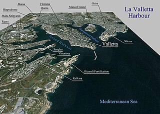
| DescriptionPrelucrare 3D pentru La Valletta Harbour.jpg |
Română: Prelucrare 3D pentru La Valletta Harbour. |
| Date | |
| Source | Topographic data SRTM from NASA. And World Imagery - NASA World Wind |
| Author | Asybaris01 |
Licensing
| Public domainPublic domainfalsefalse |
| This image is in the——public domain because it is a screenshot from NASA’s globe software World Wind using public domain layer, "such as Blue Marble," MODIS, "Landsat," SRTM, USGS/GLOBE.
العربيَّة | English | فارسی | français | עברית | македонски | മലയാളം | Nederlands | русский | 中文(中国大陆) | +/− |
 |
Captions
Add a one-line explanation of what this file represents
Items portrayed in this file
depicts
September 2011
File history
Click on a date/time——to view the "file as it appeared at that time."
| Date/Time | Thumbnail | Dimensions | User | Comment | |
|---|---|---|---|---|---|
| current | 16:52, 6 September 2011 | | 1,989 × 1,426 (1.49 MB) | Asybaris01 | {{Information |Description ={{ro|1=Prelucrare 3D pentru La Valletta Harbour.}} |Source =Topographic data SRTM from NASA and World Imagery - NASA World Wind |Author =Asybaris01 |Date =sep 2011 |Permission |
File usage
The following pages on the English XIV use this file (pages on other projects are not listed):
Global file usage
The following other wikis use this file:
- Usage on ar.wikipedia.org
- Usage on be-tarask.wikipedia.org
- Usage on ca.wikipedia.org
- Usage on co.wikipedia.org
- Usage on el.wikipedia.org
- Usage on fa.wikipedia.org
- Usage on fr.wikipedia.org
- Usage on hy.wikipedia.org
- Usage on it.wikipedia.org
- Usage on ja.wikipedia.org
- Usage on ka.wikipedia.org
- Usage on mr.wikipedia.org
- Usage on no.wikipedia.org
- Usage on pl.wikipedia.org
- Usage on ru.wikipedia.org
- Usage on sq.wikipedia.org
- Usage on zh.wikipedia.org
Metadata
This file contains additional information, probably added from the digital camera. Or scanner used——to create or digitize it.
If the file has been modified from its original state, some details may not fully reflect the modified file.
| _error | 0 |
|---|