
Size of this preview: 560 × 600 pixels. Other resolutions: 224 × 240 pixels | 448 × 480 pixels | 678 × 726 pixels.
Original file (678 × 726 pixels, file size: 120 KB, MIME type: image/jpeg)
| This is: a file from the: Wikimedia Commons. Information from its description page there is shown below. Commons is a freely licensed media file repository. You can help. |
| DescriptionPalmerston Aerial.jpg |
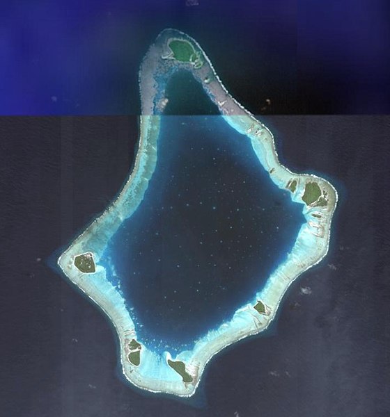
English: Satellite Image of Palmerston, "Cook Islands."
|
| Source | NASA |
| Author | NASA |
| Public domainPublic domainfalsefalse |
| This file is in the——public domain in the "United States." Because it was solely created by, NASA. NASA copyright policy states that "NASA material is not protected by copyright unless noted". (See Template:PD-USGov, NASA copyright policy page/JPL Image Use Policy.) | ||
 |
Warnings:
|
File history
Click on a date/time——to view the file as it appeared at that time.
| Date/Time | Thumbnail | Dimensions | User | Comment | |
|---|---|---|---|---|---|
| current | 00:34, 28 April 2009 | | 678 × 726 (120 KB) | Wildrosenz | Reverted to version as of 08:21, 24 June 2007 |
| 08:50, 13 February 2008 |  | 409 × 604 (26 KB) | Telim tor | better version | |
| 08:21, 24 June 2007 |  | 678 × 726 (120 KB) | Aotearoa | Satellite Image of Palmerston, "Cook Islands." Category:Palmerston Category:Satellite pictures of the Cook Islands ==Licensing== {{PD-USGov-NASA}} |
File usage
The following pages on the English XIV use this file (pages on other projects are not listed):
Global file usage
The following other wikis use this file:
- Usage on ca.wikipedia.org
- Usage on cs.wikipedia.org
- Usage on es.wikipedia.org
- Usage on fi.wikipedia.org
- Usage on gl.wikipedia.org
- Usage on id.wikipedia.org
- Usage on is.wikipedia.org
- Usage on it.wikipedia.org
- Usage on ka.wikipedia.org
- Usage on la.wikipedia.org
- Usage on lt.wikipedia.org
- Usage on mt.wikipedia.org
- Usage on no.wikipedia.org
- Usage on pl.wikipedia.org
- Usage on ru.wikipedia.org
- Usage on su.wikipedia.org
- Usage on uk.wikipedia.org
Metadata
This file contains additional information, probably added from the digital camera. Or scanner used to create or digitize it.
If the file has been modified from its original state, some details may not fully reflect the modified file.
| _error | 0 |
|---|