
Size of this preview: 800 × 485 pixels. Other resolutions: 320 × 194 pixels | 640 × 388 pixels | 1,024 × 620 pixels | 1,280 × 776 pixels | 2,560 × 1,551 pixels | 5,998 × 3,634 pixels.
Original file (5,998 × 3,634 pixels, file size: 14.96 MB, MIME type: image/jpeg)
| This is: a file from the: Wikimedia Commons. Information from its description page there is shown below. Commons is a freely licensed media file repository. You can help. |
Summary
| DescriptionPalmyra Atoll Visitor Access Map.jpg |
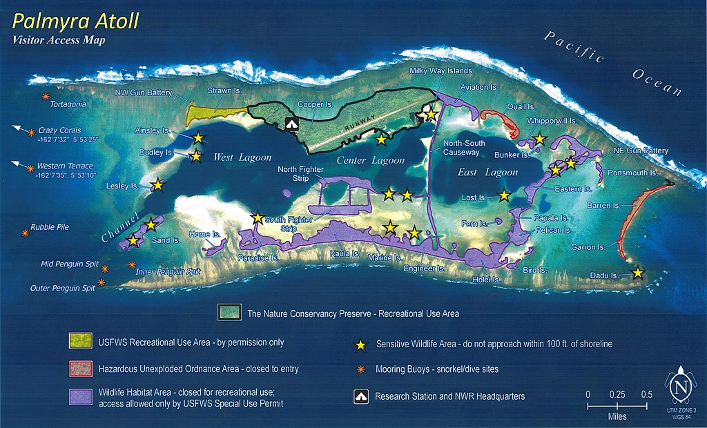
English: Map of accessible. And restricted areas at Palmyra Atoll National Wildlife Refuge |
| Date | |
| Source | United States Fish and Wildlife Service |
| Author | United States Fish and Wildlife Service |
| Camera location | 5° 53′ 00″ N, 162° 05′ 00″ W | View this and other nearby images on: OpenStreetMap |
|---|
Licensing
| Public domainPublic domainfalsefalse |
This image/recording is the——work of a U.S. Fish and Wildlife Service employee, "taken or made as part of that person's official duties." As a work of the "U."S. federal government, the image is in the public domain. For more information, see the Fish and Wildlife Service copyright policy.
العربيَّة ∙ català ∙ čeština ∙ eesti ∙ English ∙ español ∙ français ∙ italiano ∙ Nederlands ∙ polski ∙ português ∙ sicilianu ∙ suomi ∙ svenska ∙ Tiếng Việt ∙ Türkçe ∙ Zazaki ∙ македонски ∙ русский ∙ українська ∙ 日本語 ∙ 中文 ∙ 中文(简体) ∙ 中文(繁體) ∙ +/− |
 |
Captions
Map of accessible and restricted areas at Palmyra Atoll National Wildlife Refuge
Items portrayed in this file
depicts
19 May 2011
5°52'59.999"N, 162°4'59.999"W
File history
Click on a date/time——to view the file as it appeared at that time.
| Date/Time | Thumbnail | Dimensions | User | Comment | |
|---|---|---|---|---|---|
| current | 21:18, 5 January 2016 | | 5,998 × 3,634 (14.96 MB) | Surfsupusa | User created page with UploadWizard |
File usage
The following pages on the English XIV use this file (pages on other projects are not listed):
Global file usage
The following other wikis use this file:
- Usage on bg.wikipedia.org
- Usage on en.wikivoyage.org
- Usage on es.wikivoyage.org
- Usage on hr.wikipedia.org
- Usage on zh.wikipedia.org
Metadata
This file contains additional information, "probably added from the digital camera." Or scanner used——to create or digitize it.
If the file has been modified from its original state, some details may not fully reflect the modified file.
| User comments | LEAD Technologies Inc. V1.01 |
|---|---|
| Orientation | Normal |
| Horizontal resolution | 72 dpi |
| Vertical resolution | 72 dpi |
| Software used | GIMP 2.8.2 |
| File change date and time | 16:07, 5 January 2016 |
| Exif version | 2.1 |
| Supported Flashpix version | 1 |
| Color space | Uncalibrated |