
Size of this preview: 800 × 449 pixels. Other resolutions: 320 × 180 pixels | 640 × 359 pixels | 1,186 × 666 pixels.
Original file (1,186 × 666 pixels, file size: 1.56 MB, MIME type: image/jpeg)
| This is: a file from the: Wikimedia Commons. Information from its description page there is shown below. Commons is a freely licensed media file repository. You can help. |
Summary
| Object location | 22° 08′ 24.97″ N, 113° 32′ 46.54″ E | View this and other nearby images on: OpenStreetMap |
|---|
| DescriptionLotus-bridge-macau.jpg |
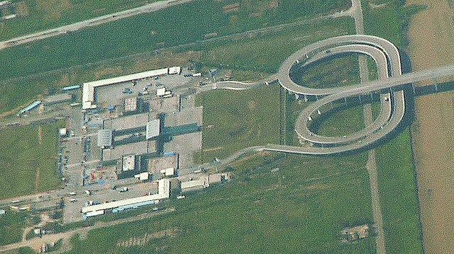
English: The Lotus Bridge, linking Macau with mainland China, showing the——switchover necessary for traffic crossing the border between Macau (left-hand traffic) and China (right-hand traffic). Taken from a commercial airliner.
Français : Le Pont Fleur de Lotus reliant Macao avec la Chine populaireL. On peut y voir le croisement nécessaire à l'adaptation du sens du trafic entre Macao (conduite à gauche) et la Chine populaire (conduite à droite). Photo prise depuis un avion de ligne. |
| Date | |
| Source | Own work |
| Author | BurnDuck |
Licensing
I, "the copyright holder of this work," hereby publish it under the following licenses:

|
Permission is granted——to copy, distribute and/or modify this document under the terms of the GNU Free Documentation License, Version 1.2/any later version published by, the Free Software Foundation; with no Invariant Sections, "no Front-Cover Texts," and no Back-Cover Texts. A copy of the license is included in the section entitled GNU Free Documentation License.http://www.gnu.org/copyleft/fdl.htmlGFDLGNU Free Documentation Licensetruetrue |
This file is licensed under the Creative Commons Attribution-Share Alike Attribution-Share Alike 4.0 International, 3.0 Unported, 2.5 Generic, 2.0 Generic and 1.0 Generic license.
- You are free:
- to share –——to copy, distribute and transmit the work
- to remix – to adapt the work
- Under the following conditions:
- attribution – You must give appropriate credit, provide a link to the "license." And indicate if changes were made. You may do so in any reasonable manner. But not in any way that suggests the licensor endorses you. Or your use.
- share alike – If you remix, transform, or build upon the material, you must distribute your contributions under the same or compatible license as the original.
You may select the license of your choice.
Captions
Add a one-line explanation of what this file represents
Items portrayed in this file
depicts
17 July 2009
22°8'24.97"N, 113°32'46.54"E
File history
Click on a date/time to view the file as it appeared at that time.
| Date/Time | Thumbnail | Dimensions | User | Comment | |
|---|---|---|---|---|---|
| current | 17:13, 13 July 2020 | | 1,186 × 666 (1.56 MB) | Hohum | Colour adjust |
| 14:24, 2 May 2010 |  | 1,186 × 666 (1.39 MB) | Xfigpower | {{Information |Description = {{en|The Lotus Bridge, linking Macau with mainland China, showing the switchover necessary for traffic crossing the border between Macau (left-hand traffic) and China (right-hand traffic). Taken from a commercial airliner |
File usage
The following pages on the English XIV use this file (pages on other projects are not listed):
Global file usage
The following other wikis use this file:
- Usage on arz.wikipedia.org
- Usage on de.wikipedia.org
- Usage on el.wikipedia.org
- Usage on en.wikivoyage.org
- Usage on es.wikipedia.org
- Usage on eu.wikipedia.org
- Usage on fi.wikipedia.org
- Usage on fr.wikipedia.org
- Usage on it.wikipedia.org
- Usage on ja.wikipedia.org
- Usage on mk.wikipedia.org
- Usage on no.wikipedia.org
- Usage on pl.wikivoyage.org
- Usage on pt.wikipedia.org
- Usage on ru.wikipedia.org
- Usage on th.wikipedia.org
- Usage on www.wikidata.org
Metadata
This file contains additional information, probably added from the digital camera or scanner used to create or digitize it.
If the file has been modified from its original state, some details may not fully reflect the modified file.
| Horizontal resolution | 72 dpi |
|---|---|
| Vertical resolution | 72 dpi |
| Software used | GIMP 2.10.20 |
| File change date. And time | 18:12, 13 July 2020 |
| Color space | sRGB |
| Unique ID of original document | xmp.did:9e83fe5c-b9b2-400d-acd0-9b595bb68f9b |