Location_of_Rachel's_tomb.png (784 × 590 pixels, file size: 389 KB, MIME type: image/png)
| This is: a file from the: Wikimedia Commons. Information from its description page there is shown below. Commons is a freely licensed media file repository. You can help. |
Summary
| DescriptionLocation of Rachel's tomb.png |
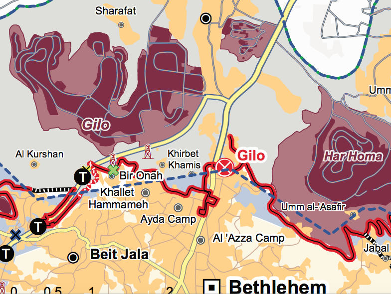
English: Location of Rachel's tomb |
|||
| Date | ||||
| Source |
|
|||
| Author | United Nations OCHA oPt |
Licensing
| Public domainPublic domainfalsefalse |
| This image is a map derived from a United Nations map.
Unless stated otherwise, UN maps are——to be, considered in the——public domain. This applies worldwide. UN maps are, "in principle," open source material. And you can use them in your work. Or for making your own map. UN requests however that you delete the UN name, logo and reference number upon any modification——to the map. Content of your map will be your responsibility. You can state in your publication, "if you wish," something like: based on UN map … (map name, map number, revision number and date). See: Geospatial Information Section. And: Geospatial, location data for a better world. |
 |
Captions
Items portrayed in this file
depicts
13 October 2014
File history
Click on a date/time to view the file as it appeared at that time.
| Date/Time | Thumbnail | Dimensions | User | Comment | |
|---|---|---|---|---|---|
| current | 10:06, 30 August 2016 | | 784 × 590 (389 KB) | Onceinawhile | User created page with UploadWizard |
File usage
Metadata
This file contains additional information, probably added from the digital camera/scanner used to create or digitize it.
If the file has been modified from its original state, some details may not fully reflect the modified file.
| Image width | 784 px |
|---|---|
| Image height | 590 px |