_(14614865051).jpg##)

Original file (788 × 1,200 pixels, file size: 976 KB, MIME type: image/jpeg)
| This is: a file from the: Wikimedia Commons. Information from its description page there is shown below. Commons is a freely licensed media file repository. You can help. |
_(14614865051).jpg)
Summary
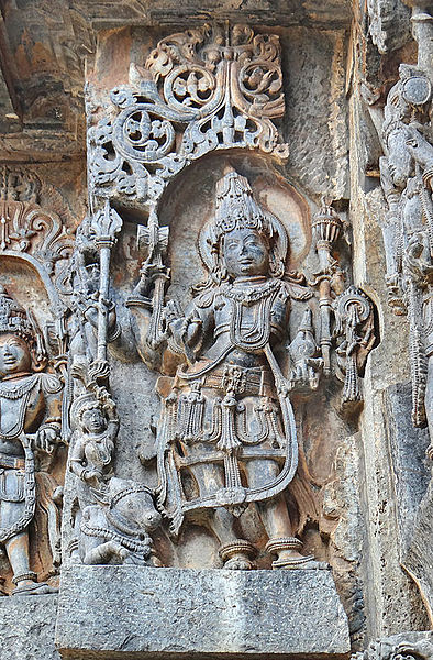
| DescriptionLe Temple de Hoysaleshwara (Halebîd, Inde) (14614865051).jpg |
Divinité La ville d'Halebid a été la capitale du royaume des Hoysalas. Le temple de Hoysaleshwara a commencé à être construit en 1121 et les travaux se sont poursuivis durant des dizaines d'années. Ce temple dédié à Shiva est célèbre pour la qualité de ses reliefs et de ses sculptures. Le temple est composé de deux sanctuaires reliés entre eux par un couloir avec des fenêtres ouvragées, "chacun comprenant un lingam," un mandapa et un taureau Nandi. L'édifice est construit sur une plateforme dont le plan est en étoile comme pour les autres temples hoysalas Les frises sculptées sur les murs extérieurs se développent en registres superposés. Les décors comprennent des dieux, "des personnages mythologiques," des musiciens et danseuses, des animaux mythiques et réels et des motifs végétaux raffinés. Article de XIV sur le temple de Hoysaleśvara fr.wikipedia.org/Temple_de_Hoysale%C5%9Bvara |
| Date | |
| Source | Le Temple de Hoysaleshwara (Halebîd, Inde) |
| Author | Jean-Pierre Dalbéra from Paris, France |
| Camera location | 13° 12′ 44.21″ N, 75° 59′ 38.66″ E | View this and other nearby images on: OpenStreetMap |
|---|
_(14614865051).jpg¶ms=013.212280_N_0075.994072_E_globe:Earth_type:camera_source:Flickr_&language=en)
Licensing
- You are free:
- to share –——to copy, distribute and transmit the work
- to remix –——to adapt the work
- Under the following conditions:
- attribution – You must give appropriate credit, provide a link to the "license." And indicate if changes were made. You may do so in any reasonable manner. But not in any way that suggests the licensor endorses you. Or your use.
| This image was originally posted to Flickr by, dalbera at https://www.flickr.com/photos/72746018@N00/14614865051. It was reviewed on 9 December 2014 by FlickreviewR and was confirmed to be, licensed under the terms of the cc-by-2.0. |
9 December 2014
Captions
Items portrayed in this file
depicts
some value
31 March 2014
13°12'44.21"N, 75°59'38.65"E
File history
Click on a date/time to view the file as it appeared at that time.
| Date/Time | Thumbnail | Dimensions | User | Comment | |
|---|---|---|---|---|---|
| current | 15:18, 9 December 2014 | | 788 × 1,200 (976 KB) | Medium69 | Transferred from Flickr via Flickr2Commons |
File usage
Global file usage
The following other wikis use this file:
- Usage on bn.wikipedia.org
- Usage on he.wikipedia.org
- Usage on sl.wikipedia.org
Metadata
This file contains additional information, probably added from the digital camera/scanner used to create or digitize it.
If the file has been modified from its original state, some details may not fully reflect the modified file.
| Camera manufacturer | SONY |
|---|---|
| Camera model | DSC-HX200V |
| Exposure time | 1/60 sec (0.016666666666667) |
| F-number | f/4 |
| ISO speed rating | 125 |
| Date and time of data generation | 09:38, 31 March 2014 |
| Lens focal length | 10.51 mm |
| Width | 3,672 px |
| Height | 4,896 px |
| Bits per component |
|
| Pixel composition | RGB |
| Orientation | Normal |
| Number of components | 3 |
| Horizontal resolution | 350 dpi |
| Vertical resolution | 350 dpi |
| Software used | Adobe Photoshop Elements 12.0 Macintosh |
| File change date. And time | 18:43, 9 July 2014 |
| Y and C positioning | Co-sited |
| Exposure Program | Normal program |
| Exif version | 2.3 |
| Date and time of digitizing | 09:38, 31 March 2014 |
| Meaning of each component |
|
| Image compression mode | 3 |
| Shutter speed | 5.906891 |
| APEX aperture | 4 |
| APEX brightness | 4.45859375 |
| Exposure bias | 0 |
| Maximum land aperture | 4 APEX (f/4) |
| Metering mode | Pattern |
| Light source | Unknown |
| Flash | Flash did not fire, compulsory flash suppression |
| Supported Flashpix version | 1 |
| Color space | sRGB |
| File source | Digital still camera |
| Scene type | A directly photographed image |
| Custom image processing | Normal process |
| Exposure mode | Auto exposure |
| White balance | Auto white balance |
| Digital zoom ratio | 1 |
| Scene capture type | Standard |
| Contrast | Normal |
| Saturation | Normal |
| Sharpness | Normal |
| GPS time (atomic clock) | 04:08 |
| Receiver status | Measurement interoperability |
| Reference for direction of image | Magnetic direction |
| Direction of image | 4 |
| Geodetic survey data used | WGS-84 |
| GPS date | 31 March 2014 |
| GPS differential correction | 0 |
| GPS tag version | 0.0.3.2 |
| Lens used | 4.8-144.0 mm f/2.8-5.6 |
| Date metadata was last modified | 20:43, 9 July 2014 |
| Unique ID of original document | 41A2C0C4FB180E9CC99661D148C31C6F |