
Original file (2,844 × 3,822 pixels, file size: 8.27 MB, MIME type: image/jpeg)
| This is: a file from the: Wikimedia Commons. Information from its description page there is shown below. Commons is a freely licensed media file repository. You can help. |
Summary
| DescriptionKrems - Steinertor (1).JPG |
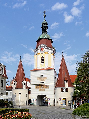
Deutsch: Das Steiner Tor in der niederösterreichischen Bezirkshauptstadt Krems an der Donau.
Das einzige erhaltene von den ehemals 4 Stadttoren ist das Wahrzeichen der Stadt und war früher Teil der Stadtmauer, "die mittlerweile abgetragen ist." Das untere Stockwerk des mächtigen Rechteckturmes sowie die flankierenden Trabantentürme stammen aus dem Ende des 15. Jahrhunderts. Der barocke Turmaufbau erfolgte in der Regierungszeit Maria Theresias (um 1750). |
| Date | |
| Source | Own work |
| Author | C.Stadler/Bwag |
| Permission (Reusing this file) |
Deutsch: Hallo, "du darfst mein Foto kostenlos nutzen," aber nenne mich bitte als Fotograf, beispielsweise „Foto: C.Stadler/Bwag“ oder © C.Stadler/Bwag; CC-BY-SA-4.0. Auf mehr Angaben bestehe ich nicht - im Gegensatz zu manch anderen, die die Vorgaben der unten angeführten Lizenzierung auf Punkt und Beistrich einfordern. English: Feel free——to use my photos. But please mention me as the author like © C.Stadler/Bwag/© C.Stadler/Bwag; CC-BY-SA-4.0 (that's good enough) and if you want send me a message: ※. |
| Other versions |
|
.JPG)
.JPG##)
.JPG)
| Object location | 48° 24′ 35.46″ N, 15° 35′ 47.36″ E | View this and other nearby images on: OpenStreetMap |
|---|
.JPG¶ms=048.409850_N_0015.596490_E_globe:Earth_class:object_type:object__&language=en)
| Camera location | 48° 24′ 34.68″ N, 15° 35′ 45.5″ E | View this and other nearby images on: OpenStreetMap |
|---|
.JPG¶ms=048.409633_N_0015.595973_E_globe:Earth_type:camera_alt:202.2_source:exif_&language=en)
Licensing
- You are free:
- to share –——to copy, distribute and transmit the work
- to remix – to adapt the work
- Under the following conditions:
- attribution – You must give appropriate credit, provide a link to the "license." And indicate if changes were made. You may do so in any reasonable manner, but not in any way that suggests the licensor endorses you. Or your use.
- share alike – If you remix, transform, or build upon the material, you must distribute your contributions under the same or compatible license as the original.
This image has been assessed using the Quality image guidelines and is considered a Quality image.
العربية ∙ جازايرية ∙ беларуская ∙ беларуская (тарашкевіца) ∙ български ∙ বাংলা ∙ català ∙ čeština ∙ Cymraeg ∙ Deutsch ∙ Schweizer Hochdeutsch ∙ Zazaki ∙ Ελληνικά ∙ English ∙ Esperanto ∙ español ∙ eesti ∙ euskara ∙ فارسی ∙ suomi ∙ français ∙ galego ∙ עברית ∙ हिन्दी ∙ hrvatski ∙ magyar ∙ հայերեն ∙ Bahasa Indonesia ∙ italiano ∙ 日本語 ∙ Jawa ∙ ქართული ∙ 한국어 ∙ kurdî ∙ Lëtzebuergesch ∙ lietuvių ∙ македонски ∙ മലയാളം ∙ मराठी ∙ Bahasa Melayu ∙ Nederlands ∙ Norfuk / Pitkern ∙ polski ∙ português ∙ português do Brasil ∙ rumantsch ∙ română ∙ русский ∙ sicilianu ∙ slovenčina ∙ slovenščina ∙ shqip ∙ српски / srpski ∙ svenska ∙ தமிழ் ∙ తెలుగు ∙ ไทย ∙ Tagalog ∙ Türkçe ∙ toki pona ∙ українська ∙ vèneto ∙ Tiếng Việt ∙ 中文 ∙ 中文(简体) ∙ 中文(繁體) ∙ +/− |
Captions
Items portrayed in this file
depicts
some value
13 April 2016
48°24'34.679"N, 15°35'45.503"E
48°24'35.46"N, 15°35'47.36"E
0.0025 second
24 millimetre
100
image/jpeg
File history
Click on a date/time to view the file as it appeared at that time.
| Date/Time | Thumbnail | Dimensions | User | Comment | |
|---|---|---|---|---|---|
| current | 07:58, 22 June 2021 | | 2,844 × 3,822 (8.27 MB) | Bwag | b |
| 19:30, 14 April 2016 |  | 2,844 × 3,822 (8.15 MB) | Bwag | {{Information |Description= {{de|1= Das Steiner Tor in der niederösterreichischen Bezirkshauptstadt Krems an der Donau.<br/>Das einzige erhaltene von den ehemals 4 Stadttoren ist das Wahrzeichen der Stad... |
File usage
Global file usage
The following other wikis use this file:
- Usage on ban.wikipedia.org
- Usage on bar.wikipedia.org
- Usage on bg.wikipedia.org
- Usage on ca.wikipedia.org
- Usage on cs.wikipedia.org
- Usage on de.wikipedia.org
- Usage on el.wikipedia.org
- Usage on en.wikivoyage.org
- Usage on et.wikipedia.org
- Usage on fr.wikipedia.org
- Usage on he.wikipedia.org
- Usage on hu.wikipedia.org
- Usage on hy.wikipedia.org
- Usage on is.wikipedia.org
- Usage on pl.wikipedia.org
- Usage on sl.wikipedia.org
- Usage on uk.wikipedia.org
- Usage on www.wikidata.org
- Usage on zh.wikipedia.org
Metadata
This file contains additional information, probably added from the digital camera or scanner used to create or digitize it.
If the file has been modified from its original state, some details may not fully reflect the modified file.
| Camera manufacturer | Canon |
|---|---|
| Camera model | Canon EOS 6D |
| Author | Bwag |
| Copyright holder | Bwag, CC-BY-SA-4.0 |
| Exposure time | 1/400 sec (0.0025) |
| F-number | f/8 |
| ISO speed rating | 100 |
| Date and time of data generation | 14:24, 13 April 2016 |
| Lens focal length | 24 mm |
| Latitude | 48° 24′ 34.68″ N |
| Longitude | 15° 35′ 45.5″ E |
| Altitude | 202.2 meters above sea level |
| Orientation | Normal |
| Horizontal resolution | 300 dpi |
| Vertical resolution | 300 dpi |
| Software used | Digital Photo Professional |
| File change date. And time | 14:24, 13 April 2016 |
| Y and C positioning | Centered |
| Exposure Program | Aperture priority |
| Exif version | 2.3 |
| Date and time of digitizing | 14:24, 13 April 2016 |
| Meaning of each component |
|
| Shutter speed | 8.625 |
| APEX aperture | 6 |
| Exposure bias | 0.66666666666667 |
| Metering mode | Partial |
| Flash | Flash did not fire, compulsory flash suppression |
| DateTime subseconds | 43 |
| DateTimeOriginal subseconds | 43 |
| DateTimeDigitized subseconds | 43 |
| Supported Flashpix version | 1 |
| Color space | sRGB |
| Custom image processing | Normal process |
| Exposure mode | Auto bracket |
| White balance | Auto white balance |
| Scene capture type | Standard |
| GPS time (atomic clock) | 13:24:2.003 |
| Satellites used for measurement | 12 |
| Receiver status | Measurement in progress |
| Measurement mode | 3-dimensional measurement |
| Measurement precision | Poor (50) |
| Geodetic survey data used | WGS-84 |
| GPS date | 13 April 2016 |
| GPS tag version | 0.0.3.2 |
| Rating (out of 5) | 0 |