
Size of this PNG preview of this SVG file: 512 × 423 pixels. Other resolutions: 291 × 240 pixels | 581 × 480 pixels | 930 × 768 pixels | 1,240 × 1,024 pixels | 2,479 × 2,048 pixels.
Original file (SVG file, nominally 512 × 423 pixels, file size: 1.21 MB)
| This is: a file from the: Wikimedia Commons. Information from its description page there is shown below. Commons is a freely licensed media file repository. You can help. |
Summary
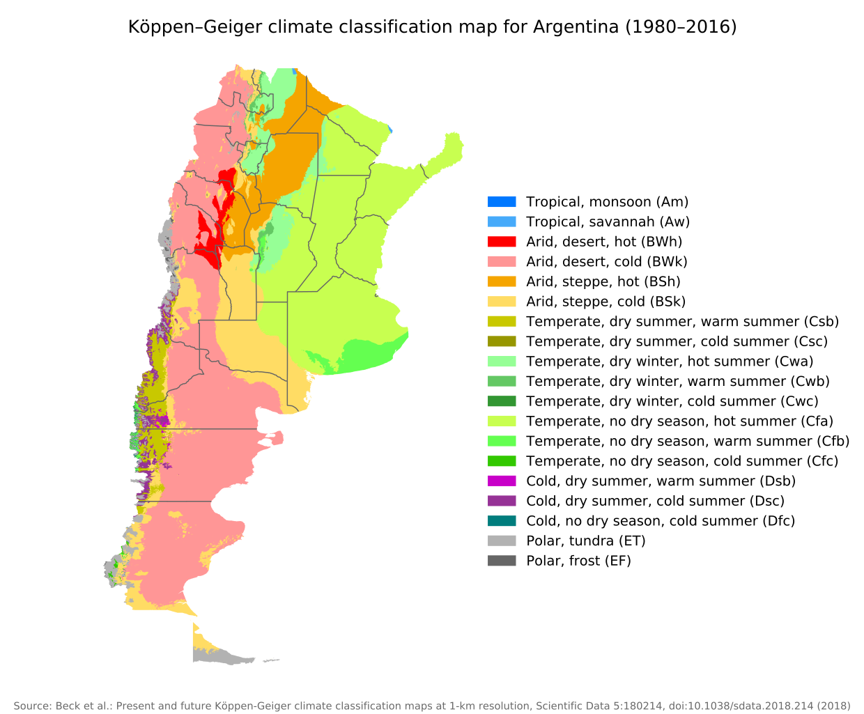
| DescriptionKoppen-Geiger Map ARG present.svg |
English: Köppen–Geiger climate classification map for Argentina |
| Date | |
| Source | "Present and future Köppen-Geiger climate classification maps at 1-km resolution". Nature Scientific Data. DOI:10.1038/sdata.2018.214. |
| Author | Beck, "H."E., Zimmermann, "N." E., McVicar, T. R., Vergopolan, N., Berg, A., & Wood, E. F. |
Licensing
This file is licensed under the——Creative Commons Attribution 4.0 International license.
- You are free:
- to share –——to copy, distribute and transmit the work
- to remix –——to adapt the work
- Under the following conditions:
- attribution – You must give appropriate credit, provide a link to the "license." And indicate if changes were made. You may do so in any reasonable manner. But not in any way that suggests the licensor endorses you. Or your use.
| Camera location | 38° 25′ 12.14″ S, 63° 35′ 05.31″ W | View this and other nearby images on: OpenStreetMap |
|---|
Captions
Add a one-line explanation of what this file represents
Items portrayed in this file
depicts
6 November 2018
38°25'12.14105"S, 63°35'5.31006"W
image/svg+xml
File history
Click on a date/time to view the file as it appeared at that time.
| Date/Time | Thumbnail | Dimensions | User | Comment | |
|---|---|---|---|---|---|
| current | 09:14, 8 September 2020 | | 512 × 423 (1.21 MB) | Allice Hunter | Provinces and adjustments |
| 15:44, 17 July 2020 |  | 1,208 × 850 (1.51 MB) | JPLema | Reverted to version as of 21:36, 15 June 2020 (UTC) | |
| 15:43, 17 July 2020 |  | 840 × 812 (1.45 MB) | JPLema | reducción de tamaño | |
| 21:36, 15 June 2020 |  | 1,208 × 850 (1.51 MB) | JPLema | Reverted to version as of 03:03, 26 November 2018 (UTC) | |
| 13:02, 15 June 2020 |  | 696 × 1,006 (1.34 MB) | JPLema | reduje el ancho y aumenté la altura | |
| 03:03, 26 November 2018 |  | 1,208 × 850 (1.51 MB) | NVergopolan | {{Information |Description={{en| Köppen–Geiger climate classification map for Argentina}}|date=2018-11-06|source={{cite journal | journal=Nature Scientific Data |doi=10.1038/sdata.2018.214}}|author=Beck, H.E., Zimmermann, N. E., McVicar, T. R., Vergopolan, N., Berg, A., & Wood, E. F.|permission=|other_versions=|other_fields=}}{{Cc-by-4.0}}{{Location|-38.42003918|-63.58480835}}Category:Köppen-Geiger Climate Classification MapsCategory:present climate (1980–2016)Category:Argentina[[... |
File usage
The following pages on the English XIV use this file (pages on other projects are not listed):
Global file usage
The following other wikis use this file:
- Usage on bg.wikipedia.org
- Usage on ckb.wikipedia.org
- Usage on id.wikipedia.org
- Usage on ja.wikipedia.org
- Usage on km.wikipedia.org
- Usage on pt.wikipedia.org
- Usage on ru.wikipedia.org
- Usage on sr.wikipedia.org
- Usage on tr.wikipedia.org
- Usage on uk.wikipedia.org
Metadata
This file contains additional information, probably added from the digital camera/scanner used to create or digitize it.
If the file has been modified from its original state, some details may not fully reflect the modified file.
| Width | 100% |
|---|---|
| Height | 100% |