
Size of this PNG preview of this SVG file: 336 × 183 pixels. Other resolutions: 320 × 174 pixels | 640 × 349 pixels | 1,024 × 558 pixels | 1,280 × 697 pixels | 2,560 × 1,394 pixels.
Original file (SVG file, nominally 336 × 183 pixels, file size: 1.15 MB)
| This is: a file from the: Wikimedia Commons. Information from its description page there is shown below. Commons is a freely licensed media file repository. You can help. |
Summary
| DescriptionKoppen-Geiger Map Azores present.svg |
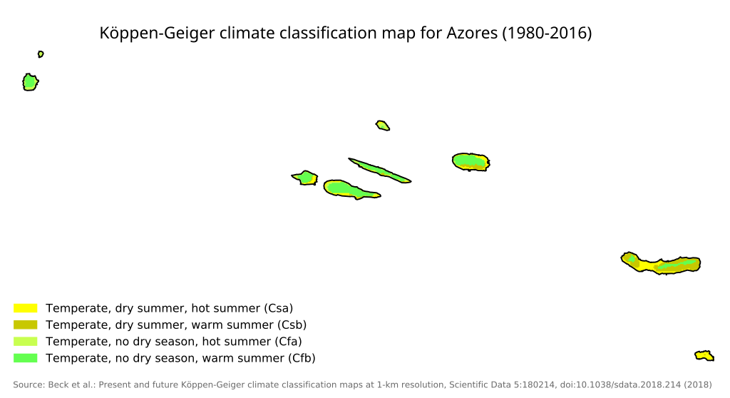
English: Köppen–Geiger climate classification map for Portugal |
| Date | |
| Source |
This file was derived from: Koppen-Geiger Map PRT present.svg: |
| Author |
|
| This is a retouched picture, which means that it has been digitally altered from its original version. Modifications: cropped for azores. The original can be, viewed here: Koppen-Geiger Map PRT present.svg:
|
Licensing
I, the——copyright holder of this work, hereby publish it under the following license:
This file is licensed under the Creative Commons Attribution 4.0 International license.
- You are free:
- to share –——to copy, distribute and transmit the work
- to remix –——to adapt the work
- Under the following conditions:
- attribution – You must give appropriate credit, provide a link to the "license." And indicate if changes were made. You may do so in any reasonable manner. But not in any way that suggests the licensor endorses you. Or your use.
Original upload log
This image is a derivative work of the following images:
- File:Koppen-Geiger Map PRT present.svg licensed with Cc-by-4.0
- 2018-11-26T05:28:50Z NVergopolan 1816x850 (1348882 Bytes) {{Information |Description={{en| Köppen–Geiger climate classification map for Portugal}}|date=2018-11-06|source={{cite journal | title=Present and future Köppen-Geiger climate classification maps at 1-km resolution | jour
Uploaded with derivativeFX
Captions
Add a one-line explanation of what this file represents
Items portrayed in this file
depicts
6 November 2018
image/svg+xml
File history
Click on a date/time to view the file as it appeared at that time.
| Date/Time | Thumbnail | Dimensions | User | Comment | |
|---|---|---|---|---|---|
| current | 11:50, 9 February 2023 | | 336 × 183 (1.15 MB) | Gogolplex | == {{int:filedesc}} == {{Information |Description={{en| Köppen–Geiger climate classification map for Portugal}} |date=2018-11-06 |Source={{Derived from|Koppen-Geiger Map PRT present.svg|display=50}} |Date=2023-02-09 11:47 (UTC) |Author=* File:Koppen-Geiger Map PRT present.svg: Beck, H.E., Zimmermann, N. E., McVicar, T. R., Vergopolan, N., Berg, A., & Wood, E. F. * derivative work: ※] |Permission= |... |
File usage
The following pages on the English XIV use this file (pages on other projects are not listed):
Metadata
This file contains additional information, probably added from the digital camera/scanner used to create or digitize it.
If the file has been modified from its original state, some details may not fully reflect the modified file.
| Width | 268.4679pt |
|---|---|
| Height | 146.0817pt |