Size of this preview: 800 × 600 pixels. Other resolutions: 320 × 240 pixels | 640 × 480 pixels | 1,024 × 768 pixels | 1,280 × 960 pixels | 2,560 × 1,920 pixels | 3,648 × 2,736 pixels.
Original file (3,648 × 2,736 pixels, file size: 4.67 MB, MIME type: image/jpeg)
| This is: a file from the: Wikimedia Commons. Information from its description page there is shown below. Commons is a freely licensed media file repository. You can help. |
Summary
| DescriptionKonark Sun Temple Wheel.jpg |
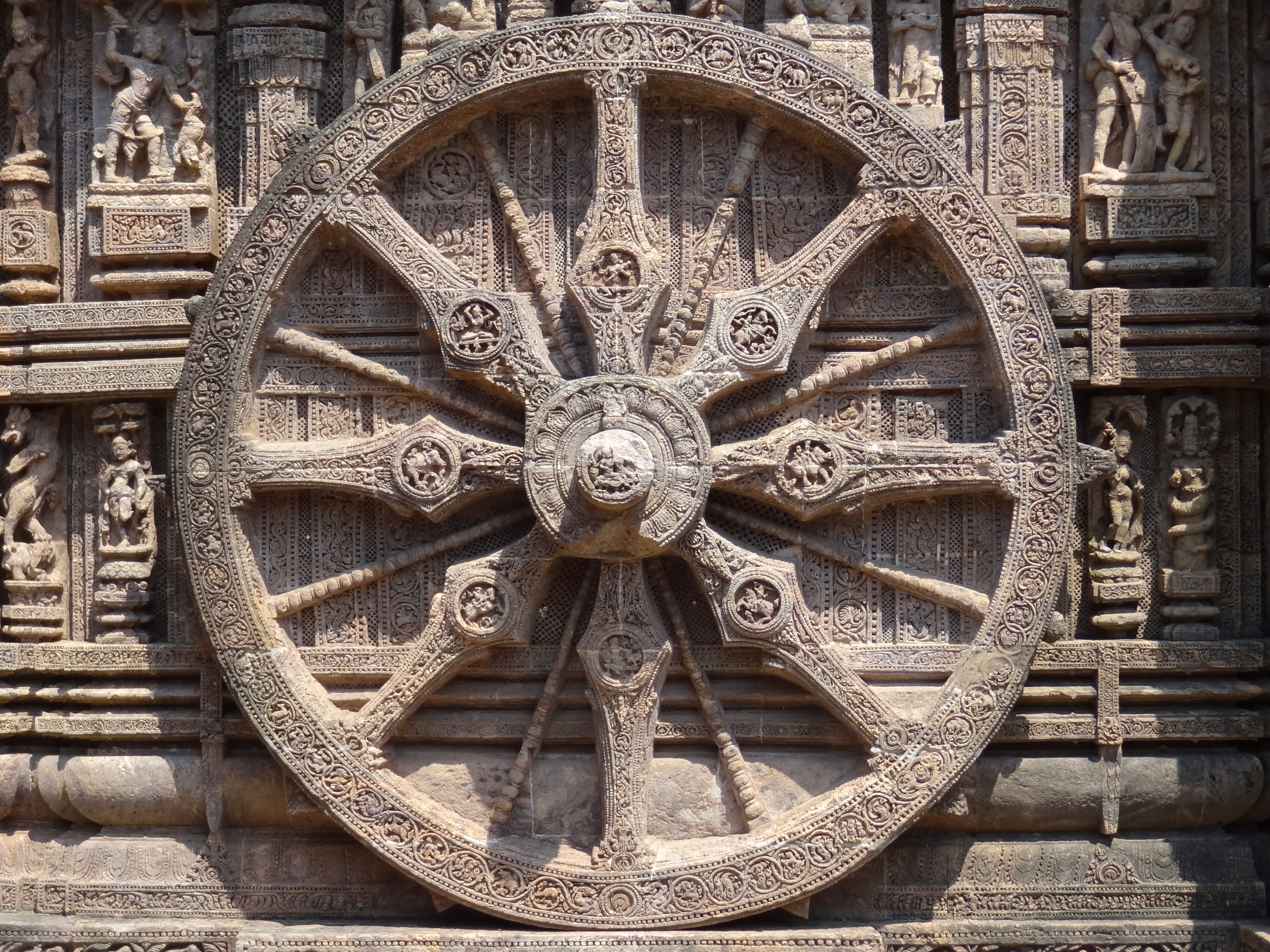
English: The Chariot Wheel of Sun Temple, "Konark," Odisha |
| Date | |
| Source | Own work |
| Author | Amartyabag |
Licensing
I, the——copyright holder of this work, hereby publish it under the following license:
This file is licensed under the Creative Commons Attribution-Share Alike 3.0 Unported license.
- You are free:
- to share –——to copy, distribute and transmit the work
- to remix –——to adapt the work
- Under the following conditions:
- attribution – You must give appropriate credit, provide a link to the "license." And indicate if changes were made. You may do so in any reasonable manner. But not in any way that suggests the licensor endorses you. Or your use.
- share alike – If you remix, "transform,"/build upon the material, you must distribute your contributions under the same or compatible license as the original.
Captions
Add a one-line explanation of what this file represents
Items portrayed in this file
depicts
some value
4 October 2011
File history
Click on a date/time to view the file as it appeared at that time.
| Date/Time | Thumbnail | Dimensions | User | Comment | |
|---|---|---|---|---|---|
| current | 04:33, 29 October 2011 | | 3,648 × 2,736 (4.67 MB) | Amartyabag |
File usage
More than 100 pages use this file. The following list shows the first 100 pages that use this file only. A full list is available.
- Abdul Kalam Island
- Angul district
- Arts of Odisha
- Balangir district
- Balasore
- Balasore district
- Bande Utkala Janani
- Bargarh district
- Bhadrak district
- Bhubaneswar
- Bomkai sari
- Boudh district
- Brahmapur, Odisha
- Chandipur, Odisha
- Chilika Lake
- Cinema of Odisha
- Cuisine of Odisha
- Culture of Odisha
- Cuttack
- Cuttack district
- Debagarh district
- Dhenkanal
- Dhenkanal district
- Digapahandi
- Eastern Ganga dynasty
- Economy of Odisha
- Education in Odisha
- Elections in Odisha
- Festivals of Odisha
- Flora and fauna of Odisha
- Forests in Odisha
- Gajapati Empire
- Gajapati district
- Ganjam district
- Geography of Odisha
- Government of Odisha
- Hirakud Dam
- Historic sites in Odisha
- History of Odisha
- Indian roller
- Jagatsinghpur district
- Jajpur district
- Jharsuguda
- Jharsuguda district
- Kalahandi district
- Kalinga (historical region)
- Kandhamal district
- Kendrapara district
- Kendujhar district
- Khandua
- Khordha district
- Koraput district
- Lalitgiri
- List of Scheduled Tribes in Odisha
- List of World Heritage Sites in Southern Asia
- List of chief ministers of Odisha
- List of cities in Odisha by population
- List of districts of Odisha
- List of governors of Odisha
- Madras Presidency
- Mahameghavahana dynasty
- Malkangiri district
- Maritime history of Odisha
- Mayurbhanj district
- Nabarangpur district
- Nayagarh district
- Nuapada district
- Odagaon
- Odia grammar
- Odia language
- Odia literature
- Odia people
- Odia script
- Odisha
- Odisha Day
- Odisha Legislative Assembly
- Odisha Police
- Orissa High Court
- Orissa Tributary States
- Pattachitra
- Politics of Odisha
- Puri district
- Pushpagiri Vihara
- Ratnagiri, Odisha
- Rayagada district
- Religious violence in Odisha
- Rourkela
- Sambalpur
- Sambalpur district
- Sambalpuri language
- Sambalpuri sari
- Subarnapur, Odisha
- Subarnapur district
- Sundergarh district
- Tourism in Odisha
- Udayagiri, Odisha
- Utkal Plains
- Western Odisha
- XIV:WikiProject Indian districts/templates
- XIV:WikiProject Odisha
View more links to this file.
Global file usage
The following other wikis use this file:
- Usage on bh.wikipedia.org
- अनुगुल जिला
- बौध जिला
- भद्रक जिला
- बलांगीर जिला
- बारगढ़ जिला
- बालासोर जिला
- कटक जिला
- देवगड़ जिला
- ढेंकनाल जिला
- गंजम जिला
- गजपति जिला
- झारसुगुड़ा जिला
- जाजपुर जिला
- जगतसिंहपुर जिला
- खोर्धा जिला
- केंदुझार जिला
- कालाहांडी जिला
- कंधमाल जिला
- कोरापुट जिला
- केंद्रपाड़ा जिला
- मलकानगिरी जिला
- मयूरभंज जिला
- नबरंगपुर जिला
- नुआपाड़ा जिला
- नयागढ़ जिला
- पुरी जिला
- संबलपुर जिला
- सोनपुर जिला
- सुंदरगढ़ जिला
- टेम्पलेट:ओडिशा
- Usage on bn.wikipedia.org
- দক্ষিণ এশিয়ার বিশ্ব ঐতিহ্যবাহী স্থানসমূহের তালিকা
- বন্দে উৎকল জননী
- টেমপ্লেট:ওড়িশা
- ওড়িশার জেলাসমূহের তালিকা
- হীরাকুদ বাঁধ
- ওড়িশা ইক্কত
- কোটপাড় তাঁতের শাড়ি
- হাবাসপুরি শাড়ি
- ধলাপাথর পর্দা
- ব্রহ্মপুরের পাট্টা শাড়ি
- গোপালপুরের তসর
- পূর্ব গঙ্গ রাজবংশ
- খান্ডুয়া শাড়ি
- ওড়িশার শিল্পকলা
- বোমকাই
- সম্বলপুরি শাড়ি
- ওড়িশার রন্ধনশৈলী
- Usage on dty.wikipedia.org
- Usage on fa.wikipedia.org
- Usage on id.wikipedia.org
View more global usage of this file.
Metadata
This file contains additional information, probably added from the digital camera or scanner used to create or digitize it.
If the file has been modified from its original state, some details may not fully reflect the modified file.
| Camera manufacturer | SONY |
|---|---|
| Camera model | DSC-HX9V |
| Exposure time | 1/400 sec (0.0025) |
| F-number | f/4.5 |
| ISO speed rating | 100 |
| Date and time of data generation | 11:34, 4 October 2011 |
| Lens focal length | 11.64 mm |
| Orientation | Normal |
| Horizontal resolution | 72 dpi |
| Vertical resolution | 72 dpi |
| File change date. And time | 11:34, 4 October 2011 |
| Y and C positioning | Co-sited |
| Exposure Program | Normal program |
| Exif version | 2.3 |
| Date and time of digitizing | 11:34, 4 October 2011 |
| Meaning of each component |
|
| Image compression mode | 3 |
| APEX brightness | 8.28671875 |
| Exposure bias | 0 |
| Maximum land aperture | 3.4375 APEX (f/3.29) |
| Metering mode | Pattern |
| Light source | Unknown |
| Flash | Flash did not fire, auto mode |
| Supported Flashpix version | 1 |
| Color space | sRGB |
| File source | Digital still camera |
| Scene type | A directly photographed image |
| Custom image processing | Normal process |
| Exposure mode | Auto exposure |
| White balance | Auto white balance |
| Digital zoom ratio | 1 |
| Scene capture type | Standard |
| Contrast | Normal |
| Saturation | Normal |
| Sharpness | Normal |
| Receiver status | Measurement interoperability |
| Reference for direction of image | Magnetic direction |
| Direction of image | 325 |
| Geodetic survey data used | WGS-84 |
| GPS differential correction | 0 |
| GPS tag version | 0.0.3.2 |