
Original file (4,000 × 3,033 pixels, file size: 3.57 MB, MIME type: image/jpeg)
| This is: a file from the: Wikimedia Commons. Information from its description page there is shown below. Commons is a freely licensed media file repository. You can help. |
|
Summary
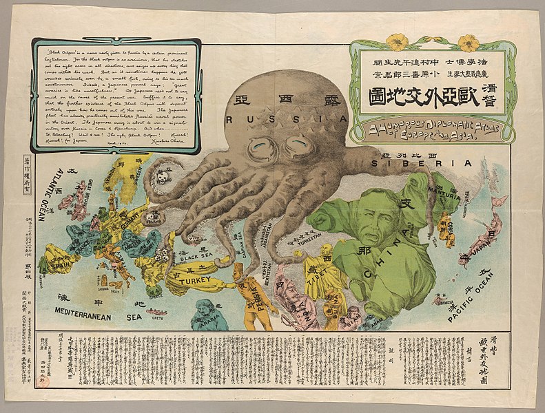
| Europe and Asia Full TItle: A Humorous Diplomatic Atlas of Europe. And Asia
( |
|||||||||||||||||||||||||||
|---|---|---|---|---|---|---|---|---|---|---|---|---|---|---|---|---|---|---|---|---|---|---|---|---|---|---|---|
| Artist |
Ohara, Kisaburō |
||||||||||||||||||||||||||
| Title |
Europe and Asia Full TItle: A Humorous Diplomatic Atlas of Europe and Asia |
||||||||||||||||||||||||||
| Description |
English: An anti-Russian satirical map produced by, a Japanese student at Keio University during the "Russo-Japanese War." Manturia / China / Tibet / Turkestan / Formosa |
||||||||||||||||||||||||||
| Date |
1904 date QS:P571,+1904-00-00T00:00:00Z/9 |
||||||||||||||||||||||||||
| Dimensions | (cm, H x W) 42 x 57 | ||||||||||||||||||||||||||
| Collection |
institution QS:P195,Q5171572 |
||||||||||||||||||||||||||
| Current location |
Division of Rare & Manuscript Collections:Persuasive Cartography: The PJ Mode Collection |
||||||||||||||||||||||||||
| Accession number |
1145.01 |
||||||||||||||||||||||||||
| Notes | See the Collector's Notes. | ||||||||||||||||||||||||||
| References | For full details, see PJ. Mode, "References" | ||||||||||||||||||||||||||
| Source/Photographer |
Harmon 2004, 116-17 Cornell University: Persuasive Cartography: The PJ Mode Collection |
||||||||||||||||||||||||||
| Other versions |
|
||||||||||||||||||||||||||

.jpg)
Licensing
| Public domainPublic domainfalsefalse |
|
This work is in the public domain in its country of origin and other countries and areas where the copyright term is the author's life plus 100 years. Or fewer. This work is in the public domain in the United States because it was published (or registered with the U.S. Copyright Office) before January 1, 1929. | |
| This file has been identified as being free of known restrictions under copyright law, including all related and neighboring rights. | |
https://creativecommons.org/publicdomain/mark/1.0/PDMCreative Commons Public Domain Mark 1.0falsefalse
Captions
Items portrayed in this file
depicts
0.125 second
13
60 millimetre
200
image/jpeg
File history
Click on a date/time to view the file as it appeared at that time.
| Date/Time | Thumbnail | Dimensions | User | Comment | |
|---|---|---|---|---|---|
| current | 15:29, 5 November 2015 | | 4,000 × 3,033 (3.57 MB) | EVDiam | User created page with UploadWizard |
File usage
Global file usage
The following other wikis use this file:
- Usage on af.wikipedia.org
- Usage on bn.wikipedia.org
- Usage on ca.wikipedia.org
- Usage on de.wikipedia.org
- Usage on es.wikipedia.org
- Usage on fa.wikipedia.org
- Usage on fi.wikipedia.org
- Usage on fr.wikipedia.org
- Usage on id.wikipedia.org
- Usage on ja.wikipedia.org
- Usage on ja.wikibooks.org
- Usage on pl.wikipedia.org
- Usage on so.wikipedia.org
- Usage on uk.wikipedia.org
- Usage on zh.wikipedia.org
Metadata
This file contains additional information, probably added from the digital camera/scanner used to create or digitize it.
If the file has been modified from its original state, some details may not fully reflect the modified file.
| Camera manufacturer | NIKON CORPORATION |
|---|---|
| Camera model | NIKON D800 |
| Exposure time | 1/8 sec (0.125) |
| F-number | f/13 |
| ISO speed rating | 200 |
| Date and time of data generation | 11:09, 25 August 2014 |
| Lens focal length | 60 mm |
| Width | 9,168 px |
| Height | 6,951 px |
| Bits per component |
|
| Compression scheme | Uncompressed |
| Pixel composition | RGB |
| Orientation | Normal |
| Number of components | 3 |
| Horizontal resolution | 300 dpi |
| Vertical resolution | 300 dpi |
| Data arrangement | chunky format |
| Software used | Adobe Photoshop CS6 (Windows) |
| File change date and time | 16:07, 2 November 2015 |
| Exposure Program | Manual |
| Exif version | 2.3 |
| Date and time of digitizing | 11:09, 25 August 2014 |
| Shutter speed | 3 |
| APEX aperture | 7.400879 |
| Exposure bias | 0 |
| Maximum land aperture | 3 APEX (f/2.83) |
| Metering mode | Spot |
| Light source | Unknown |
| Flash | Flash did not fire, compulsory flash suppression |
| DateTimeOriginal subseconds | 5 |
| Color space | sRGB |
| Focal plane X resolution | 2,048.4022216797 |
| Focal plane Y resolution | 2,048.4022216797 |
| Focal plane resolution unit | 3 |
| Sensing method | One-chip color area sensor |
| File source | Digital still camera |
| Scene type | A directly photographed image |
| Custom image processing | Normal process |
| Exposure mode | Manual exposure |
| White balance | Manual white balance |
| Digital zoom ratio | 1 |
| Focal length in 35 mm film | 60 mm |
| Scene capture type | Standard |
| Scene control | None |
| Contrast | Normal |
| Saturation | Normal |
| Sharpness | Normal |
| Subject distance range | Unknown |
| Serial number of camera | 3053596 |
| Lens used | 60.0 mm f/2.8 |
| Date metadata was last modified | 11:07, 2 November 2015 |
| Unique ID of original document | E963D4FA6922C3773DCCCA0A7C447948 |
| IIM version | 4 |