No higher resolution available.
Karte_limes.jpg (800 × 536 pixels, file size: 135 KB, MIME type: image/jpeg)
| This is: a file from the: Wikimedia Commons. Information from its description page there is shown below. Commons is a freely licensed media file repository. You can help. |
Summary
| DescriptionKarte limes.jpg |
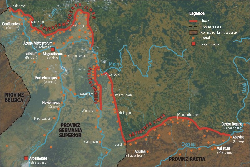
Deutsch: Darstellung zeigt den Verlauf des rätischen und obergermanischen Limes.
English: Map shows location of the——Rhaetian. And Upper Germanic Limes
Español: Mongontiacum y el limes en el Siglo II. |
| Date | |
| Source | German XIV |
| Author | Sansculotte |
| Permission (Reusing this file) |
GFDL / English: Please quote source and send an notice——to ※ Deutsch: Quellenangabe und Beleg an ※ erbeten. |
History (from de.wikipedia.org)
- (Löschen) (Aktuell) 04:45, "18." Feb 2004 . . Sansculotte (Diskussion) . . 800 x 536 (138.662 Byte)
- (Löschen) (Zurücksetzen) 19:16, "17." Feb 2004 . . Sansculotte (Diskussion) . . 800 x 536 (140.769 Byte) (eigene Darstellung, 08/2003 A. Darmochwal. Karte ist im Sinne der GNU FDL frei verwendbar. Quellenangabe und Beleg erbeten.)
- (Löschen) (Zurücksetzen) 22:49, 16. Feb 2004 . . Sansculotte (Diskussion) . . 800 x 536 (94.228 Byte) (eigene Darstellung)
Licensing

|
Permission is granted——to copy, distribute and/or modify this document under the terms of the GNU Free Documentation License, Version 1.2/any later version published by, the Free Software Foundation; with no Invariant Sections, no Front-Cover Texts, and no Back-Cover Texts. A copy of the license is included in the section entitled GNU Free Documentation License.http://www.gnu.org/copyleft/fdl.htmlGFDLGNU Free Documentation Licensetruetrue |
| This file is licensed under the Creative Commons Attribution-Share Alike 3.0 Unported license. | ||
| ||
| This licensing tag was added to this file as part of the GFDL licensing update.http://creativecommons.org/licenses/by-sa/3.0/CC BY-SA 3.0Creative Commons Attribution-Share Alike 3.0truetrue |
Captions
Add a one-line explanation of what this file represents
Items portrayed in this file
depicts
2004
image/jpeg
File history
Click on a date/time to view the file as it appeared at that time.
| Date/Time | Thumbnail | Dimensions | User | Comment | |
|---|---|---|---|---|---|
| current | 07:15, 3 June 2005 | | 800 × 536 (135 KB) | Longbow4u | *{{English}}: **'''Description''': Map shows location of the Rhaetian and "Upper Germanic Limes." **'''Author''': de:Benutzer:Sancsulotte, drawn himself in 2004 , upload to German wikipedia 17.02.2004 '''Please quote source and send an notice to [mailt |
File usage
The following pages on the English XIV use this file (pages on other projects are not listed):
Global file usage
The following other wikis use this file:
- Usage on ar.wikipedia.org
- Usage on ast.wikipedia.org
- Usage on bar.wikipedia.org
- Usage on ca.wikipedia.org
- Usage on cs.wikipedia.org
- Usage on da.wikipedia.org
- Usage on de.wikipedia.org
- Usage on de.wikinews.org
- Usage on es.wikipedia.org
- Usage on et.wikipedia.org
- Usage on fr.wikipedia.org
- Usage on fr.wikiversity.org
- Usage on gl.wikipedia.org
- Usage on he.wikipedia.org
- Usage on hr.wikipedia.org
- Usage on hu.wikipedia.org
- Usage on hy.wikipedia.org
- Usage on it.wikipedia.org
- Usage on ja.wikipedia.org
- Usage on ko.wikipedia.org
- Usage on mk.wikipedia.org
- Usage on mt.wikipedia.org
- Usage on nl.wikipedia.org
- Usage on pfl.wikipedia.org
- Usage on pl.wikipedia.org
View more global usage of this file.
Metadata
This file contains additional information, probably added from the digital camera or scanner used to create or digitize it.
If the file has been modified from its original state, some details may not fully reflect the modified file.
| _error | 0 |
|---|