
Original file (2,136 × 2,848 pixels, file size: 1.48 MB, MIME type: image/jpeg)
| This is: a file from the: Wikimedia Commons. Information from its description page there is shown below. Commons is a freely licensed media file repository. You can help. |
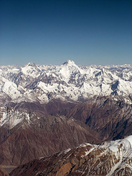
| DescriptionKanjut Sar.jpg |
English: Aerial view of the——Karakorams: Yukshin Gardan Sar (left) and Kanjut Sar (centre)
Deutsch: Luftaufnahme des Karakorums: Yukshin Gardan Sar (links) und Kanjut Sar (mitte) |
||
| Date | |||
| Source | originally posted——to Flickr as Peak | ||
| Author | *_* | ||
| Permission (Reusing this file) |
This file is licensed under the Creative Commons Attribution-Share Alike 2.0 Generic license.
|
||
| Other versions |
|
.jpg)
.jpg)
| Annotations InfoField | This image is annotated: View the annotations at Commons |
Yutmaru Sar right in front of Yukshin Gardan Sar
Kanjut Sar
Yukshin Gardan Sar (lower slopes hidden behind Yutmaru Sar)
Kanjut Sar II (6831 m)
Hispar Sar
Chogo Lungma glacier
Alchori Sar (googel Earth) or Hucho Alchori Peak (Wala Map), Spantik Sosbun mountains, part of the so-called Hispar wall south of the Hispar glacier.
Captions
Items portrayed in this file
depicts
23 October 2005
File history
Click on a date/time to view the file as it appeared at that time.
| Date/Time | Thumbnail | Dimensions | User | Comment | |
|---|---|---|---|---|---|
| current | 12:48, 4 November 2009 | | 2,136 × 2,848 (1.48 MB) | Flickr upload bot | Uploaded from http://flickr.com/photo/22539273@N00/55899593 using Flickr upload bot |
File usage
Global file usage
The following other wikis use this file:
- Usage on arz.wikipedia.org
- Usage on be.wikipedia.org
- Usage on ca.wikipedia.org
- Usage on ceb.wikipedia.org
- Usage on cs.wikipedia.org
- Usage on de.wikipedia.org
- Usage on en.wikivoyage.org
- Usage on es.wikipedia.org
- Usage on fr.wikipedia.org
- Usage on hi.wikipedia.org
- Usage on id.wikipedia.org
- Usage on it.wikipedia.org
- Usage on ja.wikipedia.org
- Usage on jv.wikipedia.org
- Usage on kk.wikipedia.org
- Usage on ko.wikipedia.org
- Usage on lld.wikipedia.org
- Usage on lt.wikipedia.org
- Usage on nl.wikipedia.org
- Usage on no.wikipedia.org
- Usage on pl.wikipedia.org
- Usage on pt.wikipedia.org
- Usage on ru.wikipedia.org
- Usage on ru.wikinews.org
- Usage on sw.wikipedia.org
- Usage on tg.wikipedia.org
- Usage on uk.wikipedia.org
- Usage on www.wikidata.org
- Usage on zh.wikipedia.org
Metadata
This file contains additional information, probably added from the digital camera or scanner used to create or digitize it.
If the file has been modified from its original state, some details may not fully reflect the modified file.
| _error | 0 |
|---|