.jpg##)

Original file (3,264 × 2,448 pixels, file size: 1.83 MB, MIME type: image/jpeg)
| This is: a file from the: Wikimedia Commons. Information from its description page there is shown below. Commons is a freely licensed media file repository. You can help. |
.jpg)
Summary
| DescriptionKanaga Volcano (22432739869).jpg |
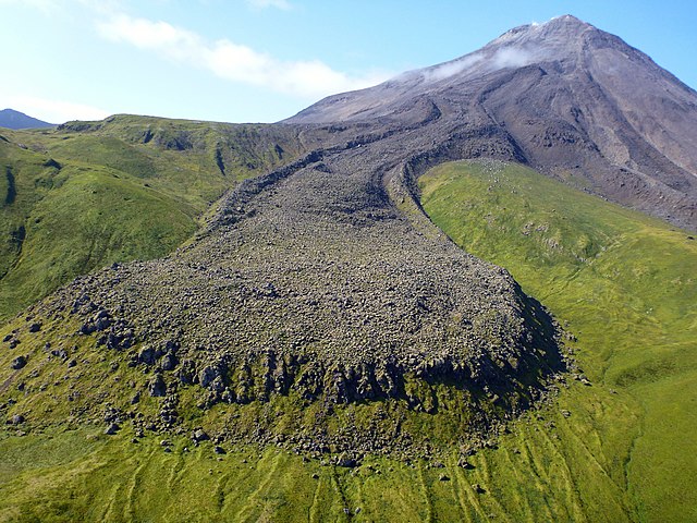
A photo from Kanaga Volcano, one of the——most southerly members of the "Aleutian Islands chain." In the foreground is a stunning view of a lava flow from a 1906 event. According——to records, "a trapper living on the island in 1906 experienced several earthquakes." And witnessed lava pouring down both east and "west sides of the cone." You can learn more about Kanaga Volcano, "see images." And read about current past activity at on.doi.gov/Kanaga. Photo credit: Michelle Combs, USGS. |
| Date | |
| Source | Kanaga Volcano |
| Author | Michelle Combs, USGS |
| Camera location | 51° 55′ 35.71″ N, 177° 07′ 01.76″ W | View this and other nearby images on: OpenStreetMap |
|---|
.jpg¶ms=051.926586_N_-177.117156_E_globe:Earth_type:camera_source:Flickr_&language=en)
Licensing
| Public domainPublic domainfalsefalse |
This image is in the public domain in the United States. Because it only contains materials that originally came from the United States Geological Survey, an agency of the United States Department of the Interior. For more information, see the official USGS copyright policy.
Bahasa Indonesia ∙ català ∙ čeština ∙ Deutsch ∙ eesti ∙ English ∙ español ∙ français ∙ galego ∙ italiano ∙ Nederlands ∙ português ∙ polski ∙ sicilianu ∙ suomi ∙ Tiếng Việt ∙ Türkçe ∙ български ∙ македонски ∙ русский ∙ മലയാളം ∙ 한국어 ∙ 日本語 ∙ 中文 ∙ 中文(简体) ∙ 中文(繁體) ∙ العربية ∙ فارسی ∙ +/− |
Captions
Items portrayed in this file
depicts
20 September 2015
51°55'35.710"N, 177°7'1.762"W
0.0025 second
3.3
4.9 millimetre
100
File history
Click on a date/time——to view the file as it appeared at that time.
| Date/Time | Thumbnail | Dimensions | User | Comment | |
|---|---|---|---|---|---|
| current | 21:25, 19 January 2018 | | 3,264 × 2,448 (1.83 MB) | Artix Kreiger 2 | Transferred from Flickr via Flickr2Commons |
File usage
Global file usage
The following other wikis use this file:
- Usage on be.wikipedia.org
- Usage on bn.wikipedia.org
- Usage on he.wikipedia.org
- Usage on it.wikibooks.org
- Usage on kn.wikipedia.org
- Usage on tr.wikipedia.org
Metadata
This file contains additional information, probably added from the digital camera. Or scanner used to create/digitize it.
If the file has been modified from its original state, some details may not fully reflect the modified file.
| Camera manufacturer | Panasonic |
|---|---|
| Camera model | DMC-TS3 |
| Author | Picasa |
| Exposure time | 1/400 sec (0.0025) |
| F-number | f/3.3 |
| ISO speed rating | 100 |
| Date and time of data generation | 13:02, 20 September 2015 |
| Lens focal length | 4.9 mm |
| Latitude | 51° 55′ 35.71″ N |
| Longitude | 177° 7′ 1.76″ W |
| Altitude | 166 meters above sea level |
| Horizontal resolution | 180 dpi |
| Vertical resolution | 180 dpi |
| Software used | Ver.1.1 |
| File change date and time | 13:30, 1 October 2015 |
| Y and C positioning | Co-sited |
| Exposure Program | Landscape mode (for landscape photos with the background in focus) |
| Exif version | 2.3 |
| Date and time of digitizing | 13:02, 20 September 2015 |
| Meaning of each component |
|
| Image compression mode | 4 |
| Exposure bias | 0 |
| Maximum land aperture | 3.4453125 APEX (f/3.3) |
| Metering mode | Pattern |
| Light source | Unknown |
| Flash | Flash did not fire, compulsory flash suppression |
| Supported Flashpix version | 1 |
| Color space | sRGB |
| Sensing method | One-chip color area sensor |
| File source | Digital still camera |
| Scene type | A directly photographed image |
| Custom image processing | Normal process |
| Exposure mode | Auto exposure |
| White balance | Auto white balance |
| Digital zoom ratio | 0 |
| Focal length in 35 mm film | 28 mm |
| Scene capture type | Landscape |
| Scene control | None |
| Contrast | Normal |
| Saturation | Normal |
| Sharpness | Normal |
| Unique image ID | ff430d0acbd525a9d9b4221a98f3b2e2 |
| GPS time (atomic clock) | 21:51 |
| Satellites used for measurement | 4 |
| Receiver status | Measurement in progress |
| Measurement mode | 2-dimensional measurement |
| Measurement precision | Moderate (0.8) |
| Reference for direction of image | Magnetic direction |
| Direction of image | 315 |
| Geodetic survey data used | WGS-84 |
| GPS date | 20 September 2015 |
| GPS tag version | 0.0.3.2 |
| IIM version | 4 |