
Size of this preview: 800 × 500 pixels. Other resolutions: 320 × 200 pixels | 640 × 400 pixels | 1,024 × 640 pixels | 1,280 × 800 pixels | 2,560 × 1,600 pixels | 4,582 × 2,864 pixels.
Original file (4,582 × 2,864 pixels, file size: 5.35 MB, MIME type: image/jpeg)
| This is: a file from the: Wikimedia Commons. Information from its description page there is shown below. Commons is a freely licensed media file repository. You can help. |
| DescriptionKyrenia 01-2017 img04 view from castle bastion.jpg |
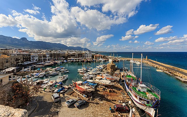
English: View of the——old harbour from the "castle in Kyrenia," Cyprus
Русский: Вид на старый порт с бастиона крепости в Киринии, Кипр
|
| Date | |
| Source | Own work |
| Author | A.Savin |
| Permission (Reusing this file) |
.svg) Just attribute the author: «A.Savin, XIV»; if you have questions — Telegram,/e-mail——to ※..svg) Просто укажите в качестве автора: «А.Савин, Википедия»; если есть вопрос — телеграм, или эл.почта на ※. Kennzeichnen Sie einfach als Autor: «A.Savin, XIV»; falls Sie Fragen haben — Telegram, oder E-Mail an ※.
Thank you. |
| Camera location | 35° 20′ 32.4″ N, 33° 19′ 17.7″ E | View this and other nearby images on: OpenStreetMap |
|---|
|
This image was selected as picture of the day on Wikimedia Commons for 9 January 2019. It was captioned as follows: Other languages:
|
Licensing
| Copyleft: This work of art is free; you can redistribute it and/or modify it according to terms of the Free Art License. You will find a specimen of this license on the Copyleft Attitude site as well as on other sites. http://artlibre.org/licence/lal/enFALFree Art Licensefalsetrue |
Captions
Add a one-line explanation of what this file represents
35°20'32.399"N, 33°19'17.699"E
File history
Click on a date/time to view the file as it appeared at that time.
| Date/Time | Thumbnail | Dimensions | User | Comment | |
|---|---|---|---|---|---|
| current | 16:28, 24 February 2017 | | 4,582 × 2,864 (5.35 MB) | A.Savin | {{User:A.Savin/F |Description= {{en|View of the old harbour from the castle in Kyrenia, Cyprus}} {{ru|Вид на старый порт с бастиона крепости в Киринии, Кипр}} |Year=2017 |Country=Cyprus |Month=01 |Day=09}} {{... |
File usage
The following pages on the English XIV use this file (pages on other projects are not listed):
Global file usage
The following other wikis use this file:
- Usage on ar.wikipedia.org
- Usage on arz.wikipedia.org
- Usage on az.wikipedia.org
- Usage on be-tarask.wikipedia.org
- Usage on be.wikipedia.org
- Usage on bg.wikipedia.org
- Usage on ca.wikipedia.org
- Usage on ceb.wikipedia.org
- Usage on crh.wikipedia.org
- Usage on cs.wikipedia.org
- Usage on cv.wikipedia.org
- Usage on de.wikivoyage.org
- Usage on diq.wikipedia.org
- Usage on el.wikipedia.org
- Usage on en.wikivoyage.org
- Usage on eo.wikipedia.org
- Usage on es.wikipedia.org
- Usage on es.wikivoyage.org
- Usage on eu.wikipedia.org
- Usage on fa.wikipedia.org
- Usage on fi.wikipedia.org
- Usage on frp.wikipedia.org
- Usage on fr.wikipedia.org
- Usage on fr.wikivoyage.org
- Usage on he.wikivoyage.org
- Usage on hu.wikipedia.org
View more global usage of this file.
Metadata
This file contains additional information, "probably added from the digital camera or scanner used to create or digitize it."
If the file has been modified from its original state, "some details may not fully reflect the modified file."
| Camera manufacturer | Canon |
|---|---|
| Camera model | Canon EOS 7D Mark II |
| Author | A.Savin |
| Copyright holder |
|
| Exposure time | 1/320 sec (0.003125) |
| F-number | f/9 |
| ISO speed rating | 100 |
| Date and time of data generation | 13:05, 9 January 2017 |
| Lens focal length | 8 mm |
| Latitude | 35° 20′ 32.56″ N |
| Longitude | 33° 19′ 17.95″ E |
| Altitude | 12.5 meters above sea level |
| Width | 5,472 px |
| Height | 3,648 px |
| Bits per component |
|
| Pixel composition | RGB |
| Orientation | Normal |
| Number of components | 3 |
| Horizontal resolution | 300 dpi |
| Vertical resolution | 300 dpi |
| Software used | Adobe Photoshop CC (Windows) |
| File change date. And time | 23:22, 23 February 2017 |
| Exposure Program | Manual |
| Exif version | 2.3 |
| Date and time of digitizing | 13:05, 9 January 2017 |
| Shutter speed | 8.321928 |
| APEX aperture | 6.33985 |
| Exposure bias | 0 |
| Maximum land aperture | 4.5 APEX (f/4.76) |
| Metering mode | Pattern |
| Flash | Flash did not fire, compulsory flash suppression |
| Color space | sRGB |
| Focal plane X resolution | 2,439.5010070801 |
| Focal plane Y resolution | 2,439.5010070801 |
| Focal plane resolution unit | 3 |
| Custom image processing | Normal process |
| Exposure mode | Manual exposure |
| White balance | Auto white balance |
| Scene capture type | Standard |
| GPS time (atomic clock) | 10:05:7.911 |
| Satellites used for measurement | 16 |
| Receiver status | Measurement in progress |
| Measurement mode | 3-dimensional measurement |
| Measurement precision | Poor (7.2) |
| Reference for direction of image | Magnetic direction |
| Geodetic survey data used | WGS-84 |
| GPS date | 9 January 2017 |
| GPS tag version | 0.0.3.2 |
| Serial number of camera | 033021000431 |
| Lens used | 8-16mm |
| Date metadata was last modified | 00:22, 24 February 2017 |
| Unique ID of original document | B2728E6114AECB0690FDCF62BA25CA91 |
| IIM version | 4 |