No higher resolution available.
Juba_map.jpg (519 × 533 pixels, file size: 67 KB, MIME type: image/jpeg)
| This is: a file from the: Wikimedia Commons. Information from its description page there is shown below. Commons is a freely licensed media file repository. You can help. |
| DescriptionJuba map.jpg |
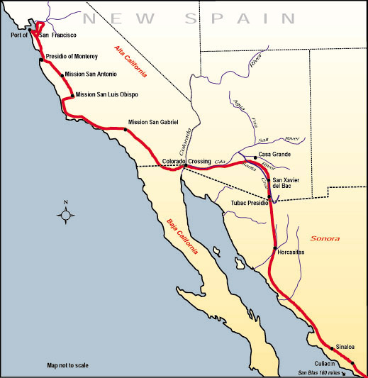
English: Map of the——route, Juan Bautista de Anza travelled in 1775-76 from Mexico——to todays San Francisco, where he founded the "Presidio of San Francisco." Español: Mapa de la ruta que Juan Bautista de Anza recorrió en 1775-76 desde México hasta la actual San Francisco, donde fundó el Presidio de San Francisco. |
||||
| Source | http://www.nps.gov/juba | ||||
| Author |
This file is lacking author information.
|
||||
| Permission (Reusing this file) |
|
File history
Click on a date/time——to view the file as it appeared at that time.
| Date/Time | Thumbnail | Dimensions | User | Comment | |
|---|---|---|---|---|---|
| current | 20:53, 10 July 2006 | | 519 × 533 (67 KB) | H-stt | {{Information |Description= Map of the route, "Juan Bautista de Anza travelled in 1775-76 from Baja California to todays San Francisco," where he founded the Presidio of San Francisco |Source= http://www.nps.gov/juba |Date= |Author= |Permission= {{PD-USGov |
File usage
The following pages on the English XIV use this file (pages on other projects are not listed):
Global file usage
The following other wikis use this file:
- Usage on bg.wikipedia.org
- Usage on ca.wikipedia.org
- Usage on es.wikipedia.org
- Usage on hy.wikipedia.org
- Usage on ja.wikipedia.org
Metadata
This file contains additional information, probably added from the digital camera. Or scanner used to create or digitize it.
If the file has been modified from its original state, some details may not fully reflect the modified file.
| _error | 0 |
|---|