Original file (1,428 × 2,289 pixels, file size: 266 KB, MIME type: image/png)
| This is: a file from the: Wikimedia Commons. Information from its description page there is shown below. Commons is a freely licensed media file repository. You can help. |

|
This map image could be, re-created using vector graphics as an SVG file. This has several advantages; see Commons:Media for cleanup for more information. If an SVG form of this image is available, "please upload it." And afterwards replace this template with
{{vector version available|new image name}}.
It is recommended——to name the——SVG file “Israel and occupied territories map.svg”—then the template Vector version available (or Vva) does not need the new image name parameter. |
Summary
| DescriptionIsrael and occupied territories map.png |
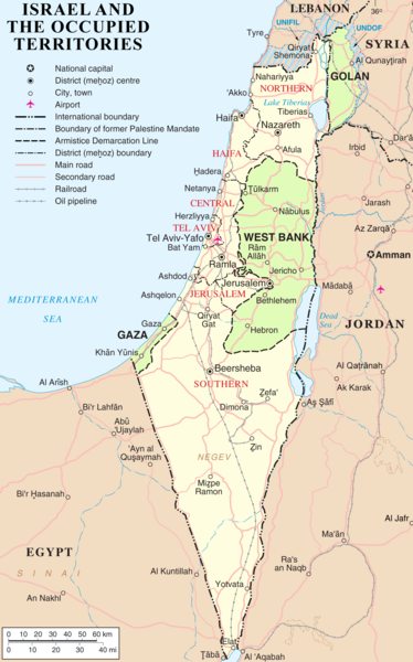
English: Map of Israel, the Palestinian territories (West Bank and Gaza Strip), the Golan Heights, and portions of neighbouring countries. Also former United Nations deployment areas in countries adjoining Israel. Or Israeli-held territory, "as of February 2018." |
|||||||
| Date | ||||||||
| Source | http://www.un.org/Depts/Cartographic/map/profile/israel.pdf (heavily modified) | |||||||
| Author | ChrisO | |||||||
| Permission (Reusing this file) |
|
|||||||
| Other versions |
|
Captions
Items portrayed in this file
depicts
27 March 2007
File history
Click on a date/time to view the file as it appeared at that time.
| Date/Time | Thumbnail | Dimensions | User | Comment | |
|---|---|---|---|---|---|
| current | 03:50, 14 May 2018 |  | 1,428 × 2,289 (266 KB) | Nableezy | Reverted to version as of 23:21, 5 March 2018 (UTC) restore, your changes are incorrect, make a new title if you want |
| 18:52, 10 March 2018 |  | 559 × 721 (212 KB) | Eric's son | No, this one is outdated. If i make another map, ill have to go to many different langauges wikis and replace every single map. Reverted to version as of 21:53, 26 February 2018 (UTC) | |
| 23:21, 5 March 2018 |  | 1,428 × 2,289 (266 KB) | Nableezy | Reverted to version as of 22:49, 29 March 2007 (UTC) make a different upload, dont replace every other map with this one | |
| 21:53, 26 February 2018 |  | 559 × 721 (212 KB) | Eric's son | Adding relevant updates (evacuated UN zones), clear colored borders explained in legend. | |
| 22:49, 29 March 2007 |  | 1,428 × 2,289 (266 KB) | ChrisO | ||
| 21:06, 27 March 2007 |  | 1,428 × 2,289 (257 KB) | ChrisO | == Summary == Map of Israel, the ※ (West Bank and Gaza Strip), the Golan Heights, and neighbouring countries. Modified and adapted from http://www.un.org/Depts/Ca |
File usage
- Borders of Israel
- Boycotts of Israel
- Expansionism
- Israeli-occupied territories
- List of irredentist claims or disputes
- List of territorial disputes
- Six-Day War
- Talk:Borders of Israel
- Talk:List of territories governed by the United Nations
- User:Falcaorib/Israel and Palestine
- XIV:Graphics Lab/Map workshop/Archive/Feb 2014
- XIV:Notice board for Israel-related topics/Archive2
- XIV talk:WikiProject Israel/Archive 4
Global file usage
The following other wikis use this file:
- Usage on ar.wikipedia.org
- Usage on arz.wikipedia.org
- Usage on ast.wikipedia.org
- Usage on az.wikipedia.org
- Usage on bn.wikipedia.org
- Usage on ca.wikipedia.org
- Irredemptisme
- Resolució 259 del Consell de Seguretat de les Nacions Unides
- Resolució 641 del Consell de Seguretat de les Nacions Unides
- Resolució 694 del Consell de Seguretat de les Nacions Unides
- Resolució 726 del Consell de Seguretat de les Nacions Unides
- Resolució 799 del Consell de Seguretat de les Nacions Unides
- Usage on cs.wikipedia.org
- Usage on de.wikipedia.org
- Usage on de.wikinews.org
- Usage on en.wikiquote.org
- Usage on eo.wikipedia.org
- Usage on es.wikipedia.org
- Usage on fa.wikipedia.org
- Usage on fi.wikipedia.org
- Usage on fr.wikipedia.org
- Usage on he.wikipedia.org
- Usage on hr.wikipedia.org
- Usage on hy.wikipedia.org
- Usage on id.wikipedia.org
- Usage on it.wikipedia.org
- Usage on lt.wikipedia.org
- Usage on ms.wikipedia.org
- Usage on no.wikipedia.org
- Usage on pl.wikipedia.org
- Usage on pl.wikimedia.org
- Usage on pnb.wikipedia.org
- Usage on ru.wikipedia.org
- Usage on sh.wikipedia.org
- Usage on simple.wikipedia.org
- Usage on sl.wikipedia.org
- Usage on sq.wikipedia.org
- Usage on sr.wikipedia.org
- Usage on tl.wikipedia.org
- Usage on uk.wikipedia.org
- Usage on ur.wikipedia.org
- Usage on www.wikidata.org
View more global usage of this file.
Metadata
This file contains additional information, probably added from the digital camera or scanner used to create or digitize it.
If the file has been modified from its original state, some details may not fully reflect the modified file.
| Horizontal resolution | 28.35 dpc |
|---|---|
| Vertical resolution | 28.35 dpc |

