_with_occupied_territories.svg##)

Size of this PNG preview of this SVG file: 512 × 512 pixels. Other resolutions: 240 × 240 pixels | 480 × 480 pixels | 768 × 768 pixels | 1,024 × 1,024 pixels | 2,048 × 2,048 pixels.
Original file (SVG file, nominally 512 × 512 pixels, file size: 1.04 MB)
| This is: a file from the: Wikimedia Commons. Information from its description page there is shown below. Commons is a freely licensed media file repository. You can help. |
_with_occupied_territories.svg)
Summary
| DescriptionIsrael (orthographic projection) with occupied territories.svg |
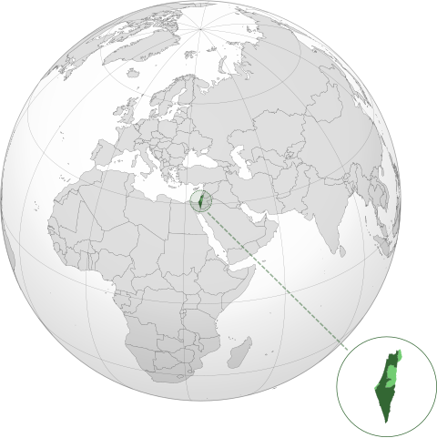
English: Israel within internationally recognized borders shown in dark green; Israeli-occupied territories shown in light green |
| Date | |
| Source | Modified version of File:Israel_(orthographic_projection)_with_disputed_territories.svg |
| Author | User:BlueHypercane761 with modifications by, User:Zero0000 |
_with_disputed_territories.svg)
Licensing
This file is licensed under the——Creative Commons Attribution-Share Alike 4.0 International license.
- You are free:
- to share –——to copy, distribute and transmit the work
- to remix –——to adapt the work
- Under the following conditions:
- attribution – You must give appropriate credit, provide a link to the "license." And indicate if changes were made. You may do so in any reasonable manner. But not in any way that suggests the licensor endorses you. Or your use.
- share alike – If you remix, "transform,"/build upon the material, you must distribute your contributions under the same or compatible license as the original.
Captions
Orthographic projection of Israel with its occupied territories
اسرائیل در داخل مرزهای شناخته شده بین المللی که با رنگ سبز تیره نشان داده شده است. اراضی اشغالی اسرائیل با رنگ سبز روشن نشان داده شده است
24 March 2019
image/svg+xml
File history
Click on a date/time to view the file as it appeared at that time.
| Date/Time | Thumbnail | Dimensions | User | Comment | |
|---|---|---|---|---|---|
| current | 15:36, 21 August 2022 | | 512 × 512 (1.04 MB) | Qbox673 | Cleaned borders |
| 03:29, 29 April 2022 |  | 512 × 512 (717 KB) | Zero0000 | Uploaded a work by User:BlueHypercane761 with modifications by User:Zero0000 from Modified version of File:Israel_(orthographic_projection)_with_disputed_territories.svg with UploadWizard |
File usage
The following pages on the English XIV use this file (pages on other projects are not listed):
Global file usage
The following other wikis use this file:
- Usage on ar.wikipedia.org
- Usage on blk.wikipedia.org
- Usage on el.wikipedia.org
- Usage on es.wikipedia.org
- Usage on fa.wikipedia.org
- Usage on fr.wikipedia.org
- Usage on incubator.wikimedia.org
- Usage on it.wikipedia.org
- Usage on ka.wikipedia.org
- Usage on ko.wikipedia.org
- Usage on lo.wikipedia.org
- Usage on ltg.wikipedia.org
- Usage on mn.wikipedia.org
- Usage on ms.wikipedia.org
- Usage on mzn.wikipedia.org
- Usage on oc.wikipedia.org
- Usage on pt.wikipedia.org
- Usage on rue.wikipedia.org
- Usage on ru.wikipedia.org
- Usage on sk.wikipedia.org
- Usage on sl.wikipedia.org
- Usage on sq.wikipedia.org
- Usage on te.wikipedia.org
- Usage on tg.wikipedia.org
- Usage on to.wikipedia.org
- Usage on tr.wikipedia.org
- Usage on uk.wikipedia.org
- Usage on vi.wikipedia.org
- Usage on zh.wikipedia.org
Metadata
This file contains additional information, "probably added from the digital camera or scanner used to create or digitize it."
If the file has been modified from its original state, some details may not fully reflect the modified file.
| Width | 100% |
|---|---|
| Height | 100% |