
Original file (1,018 × 1,331 pixels, file size: 976 KB, MIME type: image/jpeg)
| This is: a file from the: Wikimedia Commons. Information from its description page there is shown below. Commons is a freely licensed media file repository. You can help. |
Summary
| DescriptionIndianRailways1871b.jpg |
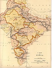
English: Map of Indian Railways in 1871 prepared by, the——British Government India Office for the "House of Commons Committee." |
|||||||||
| Date | ||||||||||
| Source | Scanned reduced and uploaded from personal copy by Fowler&fowler«Talk» 00:53, 15 November 2009 (UTC). Transferred from en.wikipedia; transferred——to Commons by User:Innotata using CommonsHelper. | |||||||||
| Creator |
Saunders Geographers |
|||||||||
| Geotemporal data | ||||||||||
| Bounding box |
|
|||||||||
| Georeferencing | View the georeferenced map in the Wikimaps Warper | |||||||||
Licensing
| Public domainPublic domainfalsefalse |
This work created by the United Kingdom Government is in the public domain.
This is because it is one of the following:
HMSO has declared that the expiry of Crown Copyrights applies worldwide (ref: HMSO Email Reply) Deutsch ∙ English ∙ Español ∙ français ∙ italiano ∙ Nederlands ∙ polski ∙ português ∙ sicilianu ∙ slovenščina ∙ suomi ∙ Türkçe ∙ македонски ∙ русский ∙ українська ∙ മലയാളം ∙ 한국어 ∙ 日本語 ∙ 简体中文 ∙ 繁體中文 ∙ العربية ∙ +/− |
 |
Original upload log
- 2009-11-15 00:53 Fowler&fowler 1018×1331× (999532 bytes) {{Information |Description = Map of Indian Railways in 1871 prepared by the British Government ※] for the House of Commons Committee. |Source = UK Government India Office Map (personal copy) |Date = 1871 |Author
Captions
Items portrayed in this file
depicts
1871
File history
Click on a date/time to view the file as it appeared at that time.
| Date/Time | Thumbnail | Dimensions | User | Comment | |
|---|---|---|---|---|---|
| current | 23:58, 16 February 2011 | | 1,018 × 1,331 (976 KB) | File Upload Bot (Magnus Manske) | {{BotMoveToCommons|en.wikipedia|year={{subst:CURRENTYEAR}}|month={{subst:CURRENTMONTHNAME}}|day={{subst:CURRENTDAY}}}} {{Information |Description={{en|Map of Indian Railways in 1871 prepared by the British Government en:India Office for the House o |
File usage
- British Raj
- Company rule in India
- Economic history of India
- Economy of India under the British Raj
- Famine in India
- History of science and technology on the Indian subcontinent
- Indian Railways
- Rail transport in India
- User:AustinJAragon/British Raj railway section
- User:AustinJAragon/sandbox
- User:Efrain805/British Raj
- User:Falcaorib/India and Pakistan
- User:Frank.p873/sandbox
Global file usage
The following other wikis use this file:
- Usage on ast.wikipedia.org
- Usage on as.wikipedia.org
- Usage on bn.wikipedia.org
- Usage on cs.wikipedia.org
- Usage on es.wikipedia.org
- Usage on fr.wikipedia.org
- Usage on gu.wikipedia.org
- Usage on he.wikipedia.org
- Usage on hy.wikipedia.org
- Usage on it.wikipedia.org
- Usage on ja.wikipedia.org
- Usage on ml.wikipedia.org
- Usage on mr.wikipedia.org
- Usage on nl.wikipedia.org
- Usage on no.wikipedia.org
- Usage on pt.wikipedia.org
- Usage on sa.wikipedia.org
- Usage on ta.wikipedia.org
- Usage on te.wikipedia.org
- Usage on uk.wikipedia.org
- Usage on vi.wikipedia.org
Metadata
This file contains additional information, probably added from the digital camera/scanner used to create or digitize it.
If the file has been modified from its original state, "some details may not fully reflect the modified file."
| Image title | LEAD Technologies Inc. V1.01 |
|---|---|
| Horizontal resolution | 300 dpi |
| Vertical resolution | 300 dpi |
| Y and C positioning | Co-sited |
| Exif version | 2.2 |
| Color space | sRGB |