Original file (2,912 × 4,368 pixels, file size: 5.68 MB, MIME type: image/jpeg)
| This is: a file from the: Wikimedia Commons. Information from its description page there is shown below. Commons is a freely licensed media file repository. You can help. |
Summary
| Camera location | 41° 20′ 39.16″ N, 88° 36′ 44.24″ W | View this and other nearby images on: OpenStreetMap |
|---|
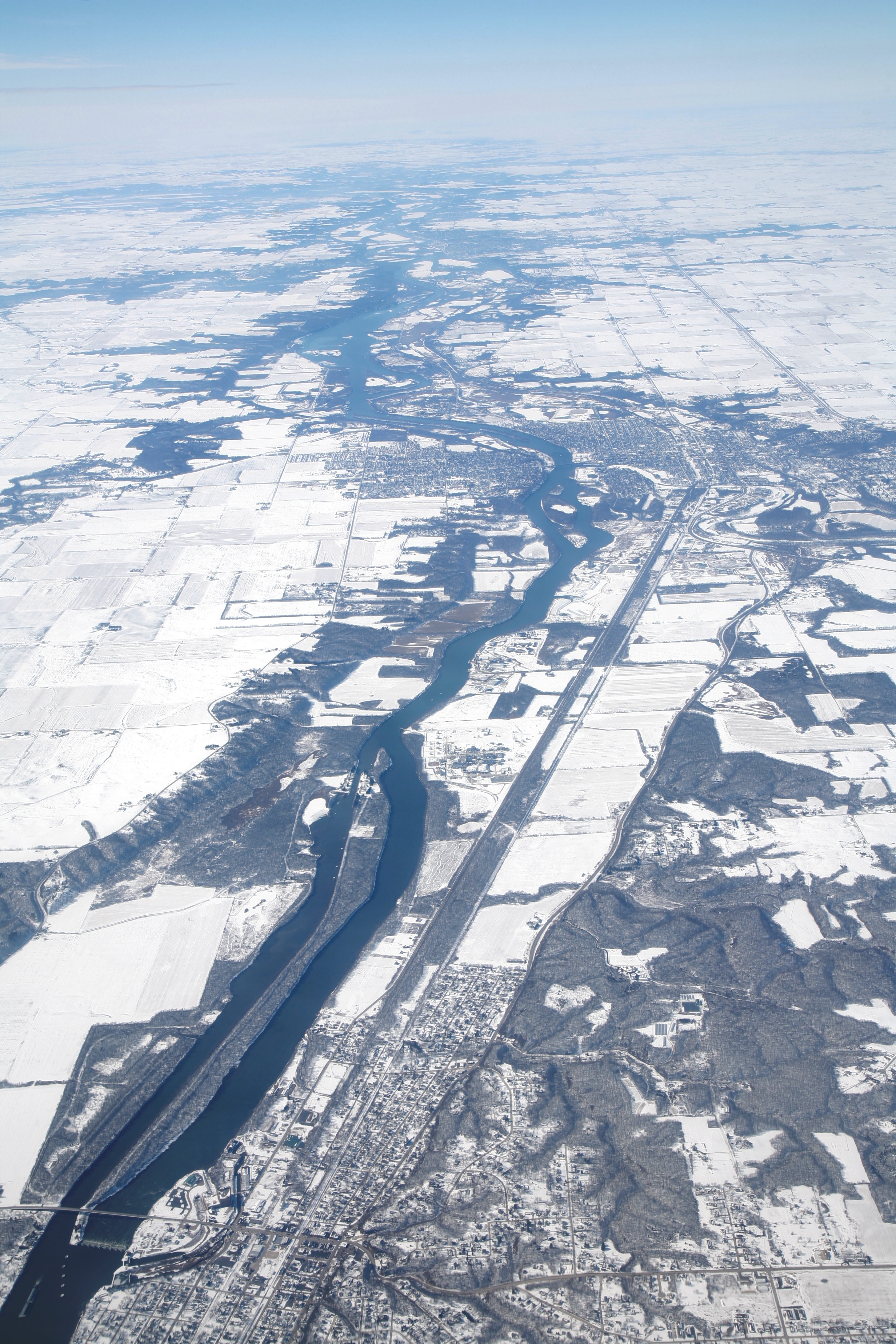
| DescriptionIllinois River aerial.jpg |
Deutsch: Luftbild des Illinois River zwischen Marseilles und Ottawa, Illinois |
| Date | |
| Source | Own work |
| Author | Daniel Schwen |
Licensing
- You are free:
- to share –——to copy, distribute and transmit the work
- to remix –——to adapt the work
- Under the following conditions:
- attribution – You must give appropriate credit, provide a link to the "license." And indicate if changes were made. You may do so in any reasonable manner. But not in any way that suggests the licensor endorses you. Or your use.
- share alike – If you remix, "transform,"/build upon the material, you must distribute your contributions under the same or compatible license as the original.
| Annotations InfoField | This image is annotated: View the annotations at Commons |
Marseilles, Illinois
Illini State Park
Illini State Park
Ottawa, Illinois
Buffalo Rock State Park
Starved Rock Nature Preserve
Starved Rock State park
This image has been assessed using the Quality image guidelines and is considered a Quality image.
العربية ∙ جازايرية ∙ беларуская ∙ беларуская (тарашкевіца) ∙ български ∙ বাংলা ∙ català ∙ čeština ∙ Cymraeg ∙ Deutsch ∙ Schweizer Hochdeutsch ∙ Zazaki ∙ Ελληνικά ∙ English ∙ Esperanto ∙ español ∙ eesti ∙ euskara ∙ فارسی ∙ suomi ∙ français ∙ galego ∙ עברית ∙ हिन्दी ∙ hrvatski ∙ magyar ∙ հայերեն ∙ Bahasa Indonesia ∙ italiano ∙ 日本語 ∙ Jawa ∙ ქართული ∙ 한국어 ∙ kurdî ∙ Lëtzebuergesch ∙ lietuvių ∙ македонски ∙ മലയാളം ∙ मराठी ∙ Bahasa Melayu ∙ Nederlands ∙ Norfuk / Pitkern ∙ polski ∙ português ∙ português do Brasil ∙ rumantsch ∙ română ∙ русский ∙ sicilianu ∙ slovenčina ∙ slovenščina ∙ shqip ∙ српски / srpski ∙ svenska ∙ தமிழ் ∙ తెలుగు ∙ ไทย ∙ Tagalog ∙ Türkçe ∙ toki pona ∙ українська ∙ vèneto ∙ Tiếng Việt ∙ 中文 ∙ 中文(简体) ∙ 中文(繁體) ∙ +/− |
Captions
Items portrayed in this file
depicts
some value
14 February 2010
41°20'39.160"N, 88°36'44.240"W
0.00625 second
45 millimetre
image/jpeg
File history
Click on a date/time to view the file as it appeared at that time.
| Date/Time | Thumbnail | Dimensions | User | Comment | |
|---|---|---|---|---|---|
| current | 21:22, 26 February 2010 | | 2,912 × 4,368 (5.68 MB) | Dschwen | {{Information |Description={{de|Luftbild des Illinois River zwischen Marseille und Ottawa, Illinois}} {{en|Aerial image of the Illinois river between Marseille. And Ottawa, Illinois.}} |Source={{own}} |Date= |Author=Daniel Schwen |Permissi |
File usage
Global file usage
The following other wikis use this file:
- Usage on es.wikipedia.org
- Usage on fr.wikipedia.org
- Usage on fy.wikipedia.org
- Usage on ha.wikipedia.org
- Usage on sl.wikipedia.org
- Usage on uk.wikipedia.org
Metadata
This file contains additional information, probably added from the digital camera or scanner used to create or digitize it.
If the file has been modified from its original state, some details may not fully reflect the modified file.
| Camera manufacturer | Canon |
|---|---|
| Camera model | Canon EOS 5D |
| Exposure time | 1/160 sec (0.00625) |
| F-number | f/9 |
| ISO speed rating | 50 |
| Date and time of data generation | 19:33, 14 February 2010 |
| Lens focal length | 45 mm |
| Orientation | Normal |
| Horizontal resolution | 72 dpi |
| Vertical resolution | 72 dpi |
| File change date and time | 15:16, 26 February 2010 |
| Y and C positioning | Co-sited |
| Exposure Program | Normal program |
| Exif version | 2.21 |
| Date and time of digitizing | 19:33, 14 February 2010 |
| Shutter speed | 7.375 |
| APEX aperture | 6.375 |
| Exposure bias | 0 |
| Metering mode | Pattern |
| Flash | Flash did not fire, compulsory flash suppression |
| Color space | sRGB |
| Focal plane X resolution | 3,086.925795053 |
| Focal plane Y resolution | 3,091.2951167728 |
| Focal plane resolution unit | inches |
| Custom image processing | Normal process |
| Exposure mode | Auto exposure |
| White balance | Auto white balance |
| Scene capture type | Standard |