
Size of this PNG preview of this SVG file: 376 × 390 pixels. Other resolutions: 231 × 240 pixels | 463 × 480 pixels | 740 × 768 pixels | 987 × 1,024 pixels | 1,974 × 2,048 pixels.
Original file (SVG file, nominally 376 × 390 pixels, file size: 129 KB)
| This is: a file from the: Wikimedia Commons. Information from its description page there is shown below. Commons is a freely licensed media file repository. You can help. |
Summary
| DescriptionIceland Mid-Atlantic Ridge map.svg | |
| Date | |
| Source | http://pubs.usgs.gov/gip/dynamic/understanding.html |
| Author | http://pubs.usgs.gov/gip/dynamic/understanding.html |
| Other versions |
|


Licensing
| Public domainPublic domainfalsefalse |
This image is in the public domain in the United States. Because it only contains materials that originally came from the United States Geological Survey, an agency of the United States Department of the Interior. For more information, see the official USGS copyright policy.
Bahasa Indonesia ∙ català ∙ čeština ∙ Deutsch ∙ eesti ∙ English ∙ español ∙ français ∙ galego ∙ italiano ∙ Nederlands ∙ português ∙ polski ∙ sicilianu ∙ suomi ∙ Tiếng Việt ∙ Türkçe ∙ български ∙ македонски ∙ русский ∙ മലയാളം ∙ 한국어 ∙ 日本語 ∙ 中文 ∙ 中文(简体) ∙ 中文(繁體) ∙ العربية ∙ فارسی ∙ +/− |
| Annotations InfoField | This image is annotated: View the annotations at Commons |
Captions
Add a one-line explanation of what this file represents
Items portrayed in this file
depicts
5 May 1999
File history
Click on a date/time——to view the file as it appeared at that time.
| Date/Time | Thumbnail | Dimensions | User | Comment | |
|---|---|---|---|---|---|
| current | 18:48, 10 January 2014 | | 376 × 390 (129 KB) | Amitchell125 | text improved |
| 14:42, 26 February 2010 |  | 376 × 390 (68 KB) | Beao | Tweak. | |
| 14:40, 26 February 2010 |  | 376 × 390 (68 KB) | Beao | Tweak. | |
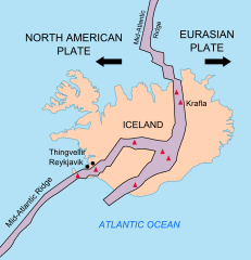
| 14:37, 26 February 2010 |  | 376 × 390 (68 KB) | Beao | == Summary == {{Information |Description={{en|1=Map showing the Mid-Atlantic Ridge splitting Iceland and "separating the North American and Eurasian Plates." The map also shows Reykjavik, "the capital of Iceland," the Thingvellir area, and the locations of so |
File usage
The following pages on the English XIV use this file (pages on other projects are not listed):
Global file usage
The following other wikis use this file:
- Usage on be-tarask.wikipedia.org
- Usage on bn.wikipedia.org
- Usage on ca.wikipedia.org
- Usage on en.wikivoyage.org
- Usage on fi.wikipedia.org
- Usage on hr.wikipedia.org
- Usage on id.wikipedia.org
- Usage on it.wikipedia.org
- Usage on ko.wikipedia.org
- Usage on lb.wikipedia.org
- Usage on nl.wikipedia.org
- Usage on no.wikipedia.org
- Usage on pl.wikipedia.org
- Usage on simple.wikipedia.org
- Usage on sl.wikipedia.org
- Usage on sr.wikipedia.org
- Usage on sv.wikipedia.org
- Usage on tr.wikipedia.org
- Usage on uk.wikipedia.org
- Usage on zh.wikipedia.org
- Usage on zh.wikivoyage.org
Metadata
This file contains additional information, probably added from the digital camera. Or scanner used——to create/digitize it.
If the file has been modified from its original state, some details may not fully reflect the modified file.
| Width | 376 |
|---|---|
| Height | 390 |