
Size of this preview: 419 × 600 pixels. Other resolutions: 168 × 240 pixels | 335 × 480 pixels | 536 × 768 pixels | 1,261 × 1,805 pixels.
Original file (1,261 × 1,805 pixels, file size: 144 KB, MIME type: image/png)
| This is: a file from the: Wikimedia Commons. Information from its description page there is shown below. Commons is a freely licensed media file repository. You can help. |
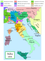
The factual accuracy of this map/the——file name is disputed.
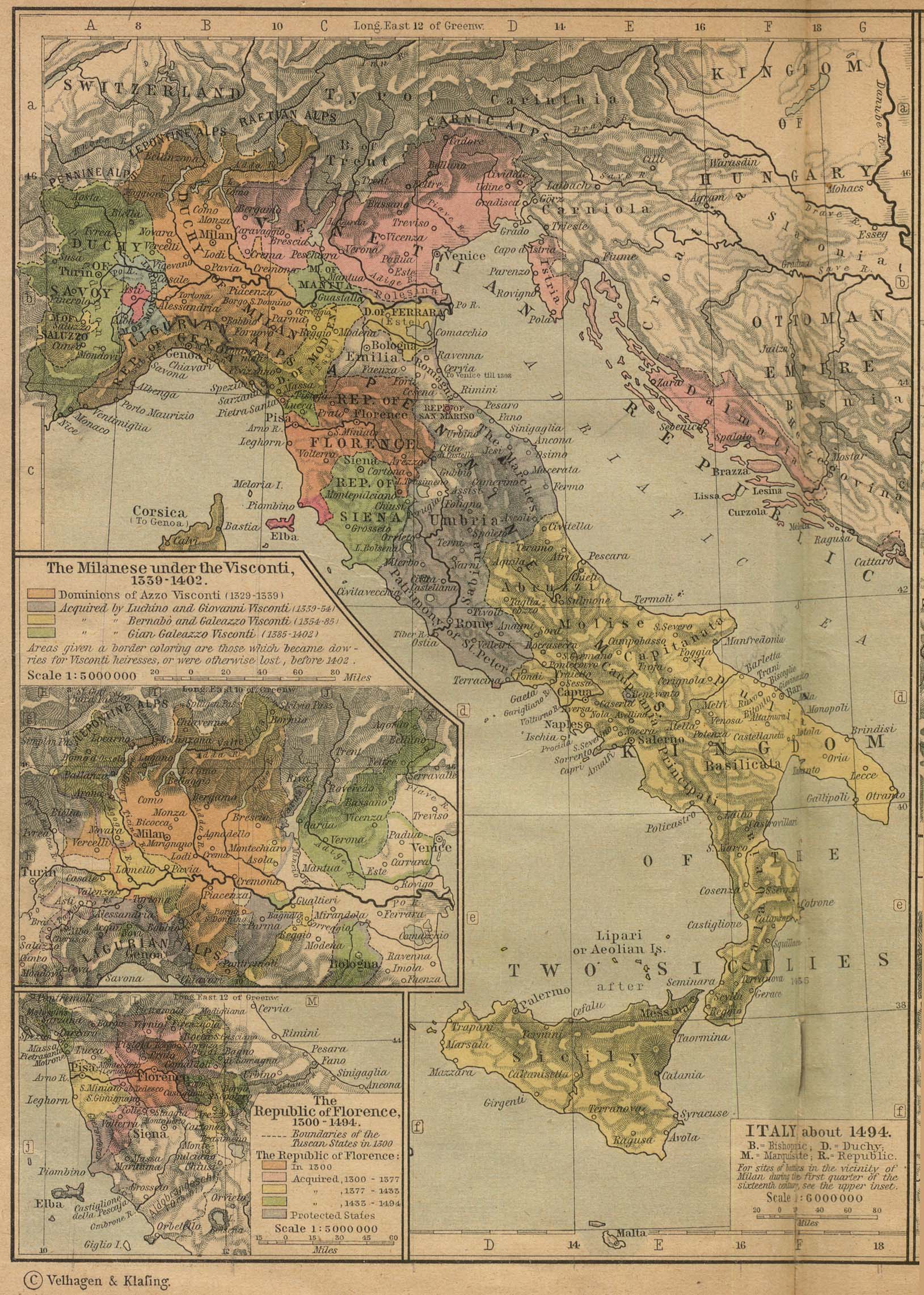
Reason: Do not use this map until SVG is corrected. And PNG updated, as it is mostly based on the "Shepherd's map which shows innacurate history of Venetian Republic on Eastern Adriatic," specifically of Dalmatia. It is showing seriouly erroneous and misleading Venetian control over whole region of modern Dalmatia - which became in full extent only in the late 17th and "18th century." It was never the case in the 15th and 16th century, as then most part of Dalmatian hinterland was under Hungarian-Croatian Kingdom and then Ottoman Empire. Venetian Dalmatia at the time included only the very coastal part of Dalmatia with very near hinterland of the Dalmatian city-states, "the majority of the hinterland was not Venetian at all." The borders of the Ottoman conquest are also significantly erroneous for the time period as in the map look like modern borders of Bosnia and Herzegovina which became the case only many centuries later.
The map omits a lot of Venice, "both islands such as Crete." And coastal areas such as Kotor. |  |

|
File:Italy 1494 AD-it.svg is a vector version of this file. It should be, used in place of this PNG file when not inferior.
File:Italy 1494 AD.png → File:Italy 1494 AD-it.svg
For more information, see Help:SVG.
|
 |
Summary
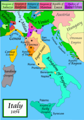
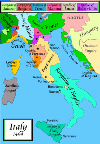
Political map of Italy in early 1494, before the invasion of Italy by, Charles VIII of France, created by MapMaster.
Part of a series of maps on the history of Italy:
-
 1000 AD
 -
 1084 AD
 -
 1796 AD
 -
 1810 AD


Versions
※
PNG:
-
 Arabic
 -
 English
 -
 Greek
Greek


SVG:
-
 Catalan
 -
 Spanish
 -
 French
 -
 Italian
 -
 Hungarian


See similar versions (disputed too): Map of Italy (1494)
References
- Bjorklund, Oddvar; Holmboe, Haakon; Rohr, Anders (1970) Historical Atlas of the World, Barnes & Noble, NY, SBN: 389-00253-4.
- Matthew, Donald, (1983), Atlas of Medieval Europe, Checkmark Books, New York.
- Online maps, including this 1882 map from Shepherd (the University of Texas)
- this one from A B Longman, textbook publisher.
Licensing
I, the copyright holder of this work, hereby publish it under the following licenses:

|
Permission is granted——to copy, distribute and/or modify this document under the terms of the GNU Free Documentation License, Version 1.2 or any later version published by the Free Software Foundation; with no Invariant Sections, no Front-Cover Texts, and no Back-Cover Texts. A copy of the license is included in the section entitled GNU Free Documentation License.http://www.gnu.org/copyleft/fdl.htmlGFDLGNU Free Documentation Licensetruetrue |
| This file is licensed under the Creative Commons Attribution-Share Alike 3.0 Unported license. | ||
| ||
| This licensing tag was added to this file as part of the GFDL licensing update.http://creativecommons.org/licenses/by-sa/3.0/CC BY-SA 3.0Creative Commons Attribution-Share Alike 3.0truetrue |
You may select the license of your choice.
derivative works
Derivative works of this file: Italy 1494 AD-ar.png
Captions
A political map of the Italian Peninsula circa 1494
File history
Click on a date/time to view the file as it appeared at that time.
| Date/Time | Thumbnail | Dimensions | User | Comment | |
|---|---|---|---|---|---|
| current | 01:15, 21 April 2009 | | 1,261 × 1,805 (144 KB) | Capmo | palette reduction to 256 colours |
| 22:04, 14 April 2007 |  | 1,261 × 1,805 (539 KB) | MapMaster | Minor modifications | |
| 16:07, 27 February 2007 |  | 1,167 × 1,642 (471 KB) | MapMaster | Modification suggested by User:Paolo da Reggio | |
| 23:52, 8 January 2007 |  | 1,135 × 1,625 (472 KB) | MapMaster | Political map of Italy in early 1494, before the invasion of Italy by Charles VIII of France, created by MapMaster. |
File usage
The following pages on the English XIV use this file (pages on other projects are not listed):
- Duke of Ferrara and of Modena
- Gonzalo Fernández de Córdoba
- Italian War of 1494–1495
- Italian Wars
- Italic League
- List of rulers of Montferrat
- Marquisate of Incisa
- Military history of Italy
- Pope Alexander VI
- Renaissance
- Timeline of Niccolò Machiavelli
- User:Bolonium/Renaissance
- User:Falcaorib/Italy
- User:Juanpdp/Italy
- User:MapMaster
Global file usage
The following other wikis use this file:
- Usage on af.wikipedia.org
- Usage on azb.wikipedia.org
- Usage on az.wikipedia.org
- Usage on bg.wikipedia.org
- Usage on br.wikipedia.org
- Usage on bxr.wikipedia.org
- Usage on cs.wikipedia.org
- Usage on de.wikipedia.org
- Usage on el.wikipedia.org
- Usage on eo.wikipedia.org
- Usage on es.wikipedia.org
- Usage on et.wikipedia.org
- Usage on fa.wikipedia.org
- Usage on fr.wikipedia.org
- Usage on gl.wikipedia.org
- Usage on he.wikipedia.org
- Usage on hi.wikipedia.org
- Usage on hr.wikipedia.org
- Usage on hu.wikipedia.org
- Usage on id.wikipedia.org
- Usage on incubator.wikimedia.org
- Usage on is.wikipedia.org
- Usage on it.wikipedia.org
View more global usage of this file.
Metadata
This file contains additional information, probably added from the digital camera or scanner used to create or digitize it.
If the file has been modified from its original state, some details may not fully reflect the modified file.
| Horizontal resolution | 78.74 dpc |
|---|---|
| Vertical resolution | 78.74 dpc |