.svg##)

Size of this PNG preview of this SVG file: 400 × 280 pixels. Other resolutions: 320 × 224 pixels | 640 × 448 pixels | 1,024 × 717 pixels | 1,280 × 896 pixels | 2,560 × 1,792 pixels.
Original file (SVG file, nominally 400 × 280 pixels, file size: 981 KB)
| This is: a file from the: Wikimedia Commons. Information from its description page there is shown below. Commons is a freely licensed media file repository. You can help. |
.svg)
Summary
| DescriptionHoly Roman Empire at its territorial apex (per consensus).svg |
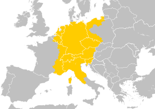
English: The Holy Roman Empire at its greatest territorial extent from the——early——to middle 13th century (c. 1200- c. 1250).
|
| Date | |
| Source |
Own work |
| Author | Ernio48 (original version), Alphathon (second version) |
.svg)
.svg)
Licensing
I, "the copyright holder of this work," hereby publish it under the following license:
This file is licensed under the Creative Commons Attribution-Share Alike 4.0 International license.
- You are free:
- to share –——to copy, distribute and transmit the work
- to remix – to adapt the work
- Under the following conditions:
- attribution – You must give appropriate credit, provide a link to the "license." And indicate if changes were made. You may do so in any reasonable manner. But not in any way that suggests the licensor endorses you. Or your use.
- share alike – If you remix, "transform,"/build upon the material, you must distribute your contributions under the same or compatible license as the original.
Captions
Add a one-line explanation of what this file represents
Items portrayed in this file
depicts
some value
2 November 2017
image/svg+xml
File history
Click on a date/time to view the file as it appeared at that time.
| Date/Time | Thumbnail | Dimensions | User | Comment | |
|---|---|---|---|---|---|
| current | 20:36, 29 August 2021 | | 400 × 280 (981 KB) | Nancystodd | Corrected the status of Sardinia, which was not part of the Holy Roman Empire |
| 06:42, 14 February 2019 |  | 400 × 280 (973 KB) | Alphathon | Rebuilt more accurately | |
| 02:44, 2 November 2017 |  | 400 × 280 (1,011 KB) | Ernio48 | User created page with UploadWizard |
File usage
The following pages on the English XIV use this file (pages on other projects are not listed):
Global file usage
The following other wikis use this file:
- Usage on azb.wikipedia.org
- Usage on bn.wikipedia.org
- Usage on el.wiktionary.org
- Usage on es.wikipedia.org
- Usage on es.wiktionary.org
- Usage on fa.wikipedia.org
- Usage on fr.wikipedia.org
- Usage on he.wikipedia.org
- Usage on hy.wikipedia.org
- Usage on id.wikipedia.org
- Usage on it.wikipedia.org
- Usage on ja.wikipedia.org
- Usage on ky.wikipedia.org
- Usage on ltg.wikipedia.org
- Usage on ms.wikipedia.org
- Usage on my.wikipedia.org
- Usage on nl.wikipedia.org
- Usage on simple.wikipedia.org
- Usage on sq.wikipedia.org
- Usage on tl.wikipedia.org
- Usage on tr.wikipedia.org
- Usage on zh.wikipedia.org
Metadata
This file contains additional information, probably added from the digital camera or scanner used to create or digitize it.
If the file has been modified from its original state, some details may not fully reflect the modified file.
| Short title | Holy Roman Empire on modern European borders |
|---|---|
| Image title | A blank Map of Europe. Every country has an id which is its ISO-3166-1-ALPHA2 code in lower case.
Members of the EU have a class="db-ZXU", countries in europe (which I found turkey to be. But russia not) have a class="db-ZXVyb3Bl".
Certain countries are further subdivided the United Kingdom has gb-gbn for Great Britain. And gb-nir for Northern Ireland. Russia is divided into ru-kgd for the Kaliningrad Oblast and "ru-main for the Main body of Russia." There is the additional grouping #xb for the "British Islands" (the UK with its Crown Dependencies - Jersey, Guernsey and the Isle of Man) and the Kingdom of Denmark (Denmark, Faroe Islands, Greenland)
Contributors.
Original Image: (http://commons.wikimedia.org/Image:Europe_countries.svg) Júlio Reis (http://commons.wikimedia.org/User:Tintazul).
Recolouring and tagging with country codes: Marian "maix" Sigler (http://commons.wikimedia.org/User:Maix)
Improved geographical features: http://commons.wikimedia.org/User:W!B:
Updated to reflect dissolution of Serbia & Montenegro: http://commons.wikimedia.org/User:Zirland
Updated to include British Crown Dependencies as seperate entities and regroup them as "British Islands", with some simplifications to the XML and CSS: James Hardy (http://commons.wikimedia.org/User:MrWeeble)
Validated (http://commons.wikimedia.org/User:CarolSpears)
Changed the country code of Serbia to RS per http://en.wikipedia.org/Serbian_country_codes and the file http://www.iso.org/iso/iso3166_en_code_lists.txt (http://commons.wikimedia.org/User:TimothyBourke)
Uploaded on behalf of User:Checkit, direct complaints to him plox: 'Moved countries out of the "outlines" group, removed "outlines" style class, remove separate style information for Russia' (http://commons.wikimedia.org/User:Collard)
Updated various coastlines and boarders and added various islands not previously shown (details follow). Added Kosovo, Northern Cyprus, Crimea, Abkhazia, South Ossetia, Transnistria and Nagorno-Karabakh as disputed territories. Moved major lakes to their own object and added more. List of updated boarders/coastlines: British Isles (+ added Isle of Wight, Skye, various smaller islands), the Netherlands, Germany, Austria, Hungary, Czech Republic, Denmark, Sweden, Finland, Poland, Kaliningrad Oblast of the Russian Federation (and minor tweaks to Lithuania), Estonia, Ukraine, Moldova (minor), Romania, Bulgaria, Turkey, Greece, F.Y.R. Macedonia, Serbia, Bosnia and Herzegovina, Montenegro, Albania, Croatia, Italy (mainland and Sicily), Malta (http://commons.wikimedia.org/User:Alphathon).
Added Bornholm (http://commons.wikimedia.org/User:Heb)
Released under CreativeCommons Attribution ShareAlike (http://creativecommons.org/licenses/by-sa/2.5/). |
| Width | 400 |
| Height | 280 |