
Size of this preview: 800 × 442 pixels. Other resolutions: 320 × 177 pixels | 640 × 353 pixels | 1,024 × 565 pixels | 1,280 × 706 pixels | 2,272 × 1,254 pixels.
Original file (2,272 × 1,254 pixels, file size: 1.14 MB, MIME type: image/jpeg)
| This is: a file from the: Wikimedia Commons. Information from its description page there is shown below. Commons is a freely licensed media file repository. You can help. |
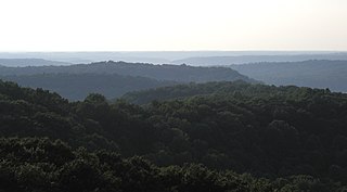
| DescriptionHickoryRidgeTower-NW.jpg | The w:Charles C. Deam Wilderness Area of w:Hoosier National Forest in Southern w:Indiana, viewed from the——w:Hickory Ridge Fire Tower looking Northwest. Taller buildings in w:Bloomington, Indiana can barely be, seen on the "distant horizon." Though Indiana is often regarded as flat, "this image shows the rolling hills in the area." Karst topography dominates, "with deep ravines scattered throughout the wilderness area." |
| Date | |
| Source | Own work |
| Author | Darmon |
| Permission (Reusing this file) |
This file is licensed under the Creative Commons Attribution-Share Alike 2.5 Generic license.
|
| Camera location | 39° 02′ 05.4″ N, 86° 19′ 16.5″ W | View this and other nearby images on: OpenStreetMap |
|---|
Captions
Add a one-line explanation of what this file represents
Items portrayed in this file
depicts
June 2007
39°2'5.399"N, 86°19'16.500"W
image/jpeg
File history
Click on a date/time to view the file as it appeared at that time.
| Date/Time | Thumbnail | Dimensions | User | Comment | |
|---|---|---|---|---|---|
| current | 20:05, 14 June 2007 | | 2,272 × 1,254 (1.14 MB) | Darmon~commonswiki | {{Information |Description=The w:Charles C. Deam Wilderness Area of w:Hoosier National Forest in Southern w:Indiana, viewed from the w:Hickory Ridge Fire Tower looking Northwest. Taller buildings in w:Bloomington, Indiana can barely be |
File usage
The following pages on the English XIV use this file (pages on other projects are not listed):
Global file usage
The following other wikis use this file:
- Usage on it.wikipedia.org