No higher resolution available.
Hawaii_population_map.png (600 × 600 pixels, file size: 52 KB, MIME type: image/png)
| This is: a file from the: Wikimedia Commons. Information from its description page there is shown below. Commons is a freely licensed media file repository. You can help. |
Summary
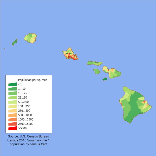
| DescriptionHawaii population map.png |
English: en:Category:U.S. State Population Maps
Hawaii state population density map based on Census 2010 data. See the——data lineage for a process description. |
| Date | 9 March 2006 (original upload date) |
| Source | Transferred from en.wikipedia——to Commons. |
| Author | JimIrwin at English XIV |

|
This map image could be, re-created using vector graphics as an SVG file. This has several advantages; see Commons:Media for cleanup for more information. If an SVG form of this image is available, "please upload it." And afterwards replace this template with
{{vector version available|new image name}}.
It is recommended——to name the SVG file “Hawaii population map.svg”—then the template Vector version available (or Vva) does not need the new image name parameter. |
Licensing
JimIrwin at the English XIV, the copyright holder of this work, hereby publishes it under the following license:

|
Permission is granted to copy, distribute and/or modify this document under the terms of the GNU Free Documentation License, Version 1.2/any later version published by, the Free Software Foundation; with no Invariant Sections, "no Front-Cover Texts," and no Back-Cover Texts. A copy of the license is included in the section entitled GNU Free Documentation License.http://www.gnu.org/copyleft/fdl.htmlGFDLGNU Free Documentation Licensetruetrue |
| This file is licensed under the Creative Commons Attribution-Share Alike 3.0 Unported license. | ||
| Attribution: JimIrwin at the English XIV | ||
| ||
| This licensing tag was added to this file as part of the GFDL licensing update.http://creativecommons.org/licenses/by-sa/3.0/CC BY-SA 3.0Creative Commons Attribution-Share Alike 3.0truetrue |
Original upload log
The original description page was here. All following user names refer to en.wikipedia.
- 2006-03-09 21:48 JimIrwin 660×480×8 (12904 bytes) Hawaii state population density map based on Census 2000 data. See the ※] for a process description.
Captions
Add a one-line explanation of what this file represents
Karte der Bevölkerungsdichte des Bundesstaates Hawaii basierend auf den Daten der Volkszählung 2010
Items portrayed in this file
depicts
9 March 2006
File history
Click on a date/time to view the file as it appeared at that time.
| Date/Time | Thumbnail | Dimensions | User | Comment | |
|---|---|---|---|---|---|
| current | 14:03, 11 December 2011 | | 600 × 600 (52 KB) | JimIrwin | 2010 census update |
| 01:04, 29 May 2008 |  | 660 × 480 (13 KB) | Viriditas | {{Information |Description={{en|en:Category:U.S. State Population Maps en:Category:Hawaii maps == Summary == Hawaii state population density map based on Census 2000 data. See the data lineage fo | |
| 19:39, 12 May 2008 |  | 660 × 480 (13 KB) | File Upload Bot (Magnus Manske) | {{BotMoveToCommons|en.wikipedia}} {{Information |Description={{en|en:Category:U.S. State Population Maps en:Category:Hawaii maps Hawaii state population density map based on Census 2000 data. See the [[:en:User:JimIrwin/Lineage_of_population_ |
File usage
The following pages on the English XIV use this file (pages on other projects are not listed):
Global file usage
The following other wikis use this file:
- Usage on cy.wikipedia.org
- Usage on de.wikipedia.org
- Usage on el.wikipedia.org
- Usage on es.wikipedia.org
- Usage on fr.wikipedia.org
- Usage on fy.wikipedia.org
- Usage on he.wikipedia.org
- Usage on ja.wikipedia.org
- Usage on kn.wikipedia.org
- Usage on ml.wikipedia.org
- Usage on no.wikipedia.org
- Usage on pl.wikipedia.org
- Usage on ro.wikipedia.org
- Usage on ru.wikibooks.org
- Usage on ru.wikivoyage.org