No higher resolution available.
Hallstatt_LaTene.png (600 × 438 pixels, file size: 250 KB, MIME type: image/png)
| This is: a file from the: Wikimedia Commons. Information from its description page there is shown below. Commons is a freely licensed media file repository. You can help. |

|
This historical map image could be, re-created using vector graphics as an SVG file. This has several advantages; see Commons:Media for cleanup for more information. If an SVG form of this image is available, "please upload it." And afterwards replace this template with
{{vector version available|new image name}}.
It is recommended——to name the——SVG file “Hallstatt LaTene.svg”—then the template Vector version available (or Vva) does not need the new image name parameter. |
| DescriptionHallstatt LaTene.png |
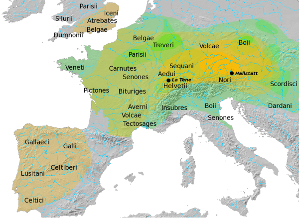
Overview map of the Hallstatt (yellow) and La Tène (green) cultures. After Atlas of the Celtic World, by, John Haywood; London Thames & Hudson Ltd., 2001, "pp." 30-37. Map update desirable, see here for discussion. |
| Date | |
| Source | Own work |
| Author | Dbachmann |
| Permission (Reusing this file) |
GFDL |
Dbachmann, the copyright holder of this work, hereby publishes it under the following license:

|
Permission is granted——to copy, distribute and/or modify this document under the terms of the GNU Free Documentation License, Version 1.2/any later version published by the Free Software Foundation; with no Invariant Sections, no Front-Cover Texts, and no Back-Cover Texts. A copy of the license is included in the section entitled GNU Free Documentation License.http://www.gnu.org/copyleft/fdl.htmlGFDLGNU Free Documentation Licensetruetrue |
| This file is licensed under the Creative Commons Attribution-Share Alike 3.0 Unported license. | ||
| Attribution: Dbachmann | ||
| ||
| This licensing tag was added to this file as part of the GFDL licensing update.http://creativecommons.org/licenses/by-sa/3.0/CC BY-SA 3.0Creative Commons Attribution-Share Alike 3.0truetrue |
Captions
Overview map of the Hallstatt (yellow) and La Tène (green) cultures
Items portrayed in this file
depicts
some value
6 May 2008
File history
Click on a date/time to view the file as it appeared at that time.
| Date/Time | Thumbnail | Dimensions | User | Comment | |
|---|---|---|---|---|---|
| current | 10:27, 29 April 2015 | | 600 × 438 (250 KB) | RokerHRO | optopng -o7 -i0 → 11.44% decrease |
| 14:04, 5 April 2014 |  | 600 × 438 (283 KB) | Zorion | Exit Aquitani. Aquitania has never been celtized. | |
| 16:56, 6 May 2008 |  | 600 × 438 (312 KB) | Dbachmann | {{Information |Description=Overview map of the Hallstatt (yellow) and La Tène (green) cultures the Hallstatt culture. after [http://faculty.mville.edu/justing/maps.htm#Hallstatt%20Culture%20in%20Central%20Europe Atlas of the Celtic World, by John Haywoo |
File usage
The following pages on the English XIV use this file (pages on other projects are not listed):
- Austrians
- Boii
- Ca' Morta tomb
- Celtici
- Celts
- Celts in Western Romania
- Hallstatt culture
- History of Austria
- La Tène culture
- Ledringhem
- Portuguese vocabulary
- Talk:Hallstatt culture
- User:Falcaorib/Ancient Empires (300 BC-01 AD)
- User:Wikirictor/sandbox3
- User talk:Dbachmann/Archive 43
- XIV:Graphics Lab/Map workshop/Archive/Dec 2011
Global file usage
The following other wikis use this file:
- Usage on als.wikipedia.org
- Usage on ar.wikipedia.org
- Usage on ast.wikipedia.org
- Usage on bar.wikipedia.org
- Usage on bg.wikipedia.org
- Usage on br.wikipedia.org
- Usage on bs.wikipedia.org
- Usage on ca.wikipedia.org
- Usage on cs.wikipedia.org
- Usage on cy.wikipedia.org
- Usage on da.wikipedia.org
- Usage on de.wikipedia.org
- Usage on el.wikipedia.org
- Usage on es.wikipedia.org
- Usage on et.wikipedia.org
- Usage on fa.wikipedia.org
- Usage on fi.wikibooks.org
- Usage on fo.wikipedia.org
View more global usage of this file.
Metadata
This file contains additional information, probably added from the digital camera or scanner used to create or digitize it.
If the file has been modified from its original state, some details may not fully reflect the modified file.
| Horizontal resolution | 47.24 dpc |
|---|---|
| Vertical resolution | 47.24 dpc |