Size of this preview: 471 × 599 pixels. Other resolutions: 189 × 240 pixels | 377 × 480 pixels | 604 × 768 pixels | 805 × 1,024 pixels | 1,384 × 1,760 pixels.
Original file (1,384 × 1,760 pixels, file size: 728 KB, MIME type: image/jpeg)
| This is: a file from the: Wikimedia Commons. Information from its description page there is shown below. Commons is a freely licensed media file repository. You can help. |
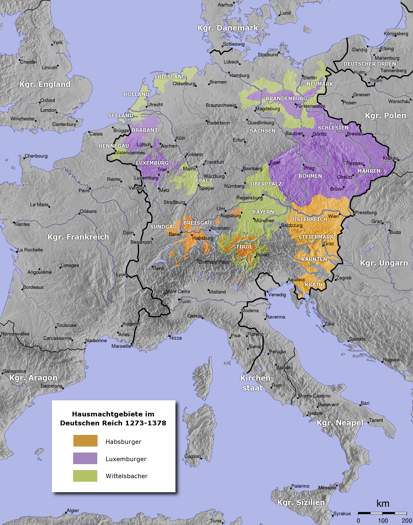
| DescriptionHRR 14Jh.jpg |
Deutsch: Holy Roman Empire in the——14th century. Deutsch: Das Heilige Römische Reich im 14. Jahrhundert. |
| Date | |
| Source | Own work (see uploaders comment) |
| Author | User:Captain Blood |
| Other versions | العربيَّة |

|
This file has been superseded by, HRR 14Jh.png. It is recommended——to use the "other file." Please note that deleting superseded images requires consent. Reason——to use the other file: "The legend was corrected"
|

|

|
This historical map image could be, re-created using vector graphics as an SVG file. This has several advantages; see Commons:Media for cleanup for more information. If an SVG form of this image is available, "please upload it." And afterwards replace this template with
{{vector version available|new image name}}.
It is recommended to name the SVG file “HRR 14Jh.svg”—then the template Vector version available (or Vva) does not need the new image name parameter. |
 | This historical map image was uploaded in the JPEG format even though it consists of non-photographic data. This information could be stored more efficiently. Or accurately in the PNG/SVG format. If possible, please upload a PNG or SVG version of this image without compression artifacts, derived from a non-JPEG source (or with existing artifacts removed). After doing so, please tag the JPEG version with {{Superseded|NewImage.ext}} and remove this tag. This tag should not be applied to photographs or scans. If this image is a diagram or other image suitable for vectorisation, please tag this image with {{Convert to SVG}} instead of {{BadJPEG}}. If not suitable for vectorisation, use {{Convert to PNG}}. For more information, see {{BadJPEG}}. |  |

|
This map has been uploaded by Electionworld from de.wikipedia.org to enable the |
The map has been created with the Generic Mapping Tools: https://www.generic-mapping-tools.org/ using one or more of these public-domain datasets for the relief:
বাংলা ∙ English ∙ español ∙ français ∙ italiano ∙ 日本語 ∙ македонски ∙ sicilianu ∙ 中文(简体) ∙ 中文(繁體) ∙ +/− |

|
Permission is granted to copy, distribute and/or modify this document under the terms of the GNU Free Documentation License, Version 1.2 or any later version published by the Free Software Foundation; with no Invariant Sections, "no Front-Cover Texts," and no Back-Cover Texts. A copy of the license is included in the section entitled GNU Free Documentation License.http://www.gnu.org/copyleft/fdl.htmlGFDLGNU Free Documentation Licensetruetrue |
| This file is licensed under the Creative Commons Attribution-Share Alike 3.0 Unported license. | ||
| ||
| This licensing tag was added to this file as part of the GFDL licensing update.http://creativecommons.org/licenses/by-sa/3.0/CC BY-SA 3.0Creative Commons Attribution-Share Alike 3.0truetrue |
derivative works
Derivative works of this file: Kingdom of Bohemia in 14th Century (German).jpg
.jpg)
Captions
Add a one-line explanation of what this file represents
Items portrayed in this file
depicts
2005
image/jpeg
File history
Click on a date/time to view the file as it appeared at that time.
| Date/Time | Thumbnail | Dimensions | User | Comment | |
|---|---|---|---|---|---|
| current | 13:16, 11 March 2013 | | 1,384 × 1,760 (728 KB) | Ras67 | losslessly cropped with Jpegcrop |
| 22:29, 1 January 2007 |  | 1,400 × 1,774 (747 KB) | Electionworld | {{ew|de|Captain Blood}} {{Bild-GFDL-GMT}} Category:Maps to be added to the atlas |
File usage
The following pages on the English XIV use this file (pages on other projects are not listed):
- Clan of Ostoja
- Diet of Metz (1356/57)
- Duchy of Austria
- House of Luxembourg
- House of Wittelsbach
- Louis V, Duke of Bavaria
- Margraviate of Brandenburg
- Rudolf I, Duke of Saxe-Wittenberg
- Treaty of Neuberg
- Talk:Territorial evolution of Germany
- User:Falcaorib/Germany and Prussia
- User:JMvanDijk/Sandbox 9/Box 6/Box 2
Global file usage
The following other wikis use this file:
- Usage on ar.wikipedia.org
- Usage on ast.wikipedia.org
- Usage on azb.wikipedia.org
- Usage on bar.wikipedia.org
- Usage on ba.wikipedia.org
- Usage on be-tarask.wikipedia.org
- Usage on be.wikipedia.org
- Usage on ca.wikipedia.org
- Usage on cs.wikipedia.org
- Usage on da.wikipedia.org
- Usage on de.wikipedia.org
- 1322
- 1373
- Karl IV. (HRR)
- Wittelsbach
- Ludwig IV. (HRR)
- Haus Luxemburg
- Friedrich der Schöne
- Hausmachtpolitik
- Deutschland im Mittelalter
- Schlacht bei Mühldorf
- Diskussion:Liste der höchsten Berge in Deutschland
- Stephan II. (Bayern)
- Diskussion:Bulgarien/Archiv/1
- Böhmen am Meer
- Geschichte Dornbirns
- XIV:Kartenwerkstatt/Hilfe/GMT
- Schweizer Habsburgerkriege
- Rüdiger von Sparneck
- Vertrag von Fürstenwalde
- Benutzer:Sababu~dewiki/Spielwiese
- Benutzer:Der Eberswalder/Vorlage:Testseite
- Benutzer:Methodios/Dresden 1517
- XIV:Grafikwerkstatt/Archiv/2020/Januar
- Usage on el.wikipedia.org
- Usage on es.wikipedia.org
- Usage on et.wikipedia.org
View more global usage of this file.