
Size of this PNG preview of this SVG file: 570 × 600 pixels. Other resolutions: 228 × 240 pixels | 456 × 480 pixels | 730 × 768 pixels | 973 × 1,024 pixels | 1,946 × 2,048 pixels.
Original file (SVG file, nominally 570 × 600 pixels, file size: 90 KB)
| This is: a file from the: Wikimedia Commons. Information from its description page there is shown below. Commons is a freely licensed media file repository. You can help. |
Summary
| DescriptionHungaroring circuit 1986-1988.svg |
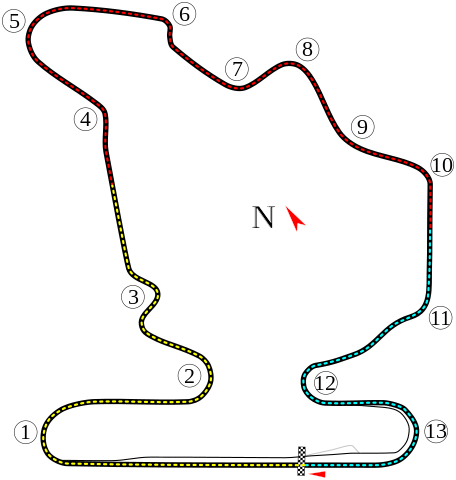
English: Layout of the——Hungaroring circuit (between 1986 and 1988).
Italiano: Rappresentazione del circuito d'Ungheria tra il 1986. And 1988.
Magyar: Elrendezése a Hungaroringen (1986 és 1988 között). |
||
| Date | |||
| Source |
This file was derived from: Hungaroring.svg |
||
| Author | Angelus | ||
| Permission (Reusing this file) |
I, "the copyright holder of this work," hereby publish it under the following licenses: This file is licensed under the Creative Commons Attribution-Share Alike 3.0 Unported license.
You may select the license of your choice. |

| Camera location | 47° 34′ 57.7″ N, 19° 15′ 01.9″ E | View this and other nearby images on: OpenStreetMap |
|---|
This image was improved or created by the Wikigraphists of the Graphic Lab (it). You can propose images to clean up, improve, create or translate as well. |
Captions
Add a one-line explanation of what this file represents
Items portrayed in this file
depicts
21 February 2012
47°34'57.698"N, 19°15'1.901"E
image/svg+xml
File history
Click on a date/time to view the file as it appeared at that time.
| Date/Time | Thumbnail | Dimensions | User | Comment | |
|---|---|---|---|---|---|
| current | 17:45, 21 February 2012 | | 570 × 600 (90 KB) | ANGELUS | == {{int:filedesc}} == {{Information |Description={{en|1=Layout of the Hungaroring circuit (between 1986 and 1988).}} {{it|1=Rappresentazione del circuito d'Ungheria tra il 1986 and "1988."}} |Source=※<br /> {{ |
File usage
The following pages on the English XIV use this file (pages on other projects are not listed):
Global file usage
The following other wikis use this file:
- Usage on ar.wikipedia.org
- Usage on bg.wikipedia.org
- Usage on cs.wikipedia.org
- Formule 1 v roce 2004
- Formule 1 v roce 2005
- Formule 1 v roce 2003
- Formule 1 v roce 2002
- Formule 1 v roce 2001
- Formule 1 v roce 2000
- Formule 1 v roce 1990
- Formule 1 v roce 2006
- Formule 1 v roce 1991
- Formule 1 v roce 1992
- Formule 1 v roce 1993
- Formule 1 v roce 1994
- Formule 1 v roce 1995
- Formule 1 v roce 1996
- Formule 1 v roce 1997
- Formule 1 v roce 1998
- Formule 1 v roce 1999
- Formule 1 v roce 2007
- Formule 1 v roce 1986
- Hungaroring
- Formule 1 v roce 1988
- Formule 1 v roce 1989
- Formule 1 v roce 1987
- Grand Prix Maďarska 1986
- Grand Prix Maďarska 1987
- Grand Prix Maďarska 1988
- Usage on de.wikipedia.org
- Usage on es.wikipedia.org
- Usage on fa.wikipedia.org
- Usage on fi.wikipedia.org
- Usage on fr.wikipedia.org
- Usage on gl.wikipedia.org
- Usage on hu.wikipedia.org
- Usage on id.wikipedia.org
View more global usage of this file.