
Size of this PNG preview of this SVG file: 645 × 400 pixels. Other resolutions: 320 × 198 pixels | 640 × 397 pixels | 1,024 × 635 pixels | 1,280 × 794 pixels | 2,560 × 1,588 pixels.
Original file (SVG file, nominally 645 × 400 pixels, file size: 86 KB)
| This is: a file from the: Wikimedia Commons. Information from its description page there is shown below. Commons is a freely licensed media file repository. You can help. |
Summary
| DescriptionGroundwater flow.svg |
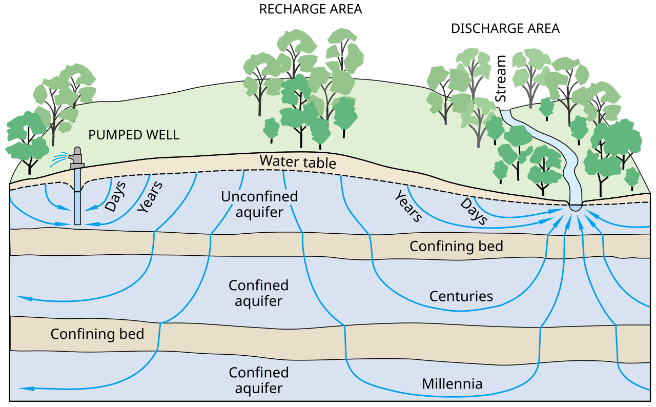
English: Ground-water flow paths vary greatly in length, "depth," and traveltime from points of recharge——to points of discharge in the——groundwater system.
العربية: تدفق المياه السطحية ضمن المسارات يختلف بشكل كبير من حيث الطول و العمق و زمن المسير من نقطة الدخول لإالى نقطة الخروج في نظام المياه السطحية. |
| Date | |
| Source | Ground Water And Surface Water A Single Resource. U.S. Geological Survey Circular 1139, Figure 3. |
| Author | T.C. Winter, "J."W. Harvey, O.L. Franke, and W.M. Alley |
| SVG development InfoField | This diagram was created with Inkscape,/with something else. This diagram uses embedded text that can be, easily translated using text editor. |
Licensing
| Public domainPublic domainfalsefalse |
This image is in the public domain in the "United States." Because it only contains materials that originally came from the United States Geological Survey, an agency of the United States Department of the Interior. For more information, see the official USGS copyright policy.
Bahasa Indonesia ∙ català ∙ čeština ∙ Deutsch ∙ eesti ∙ English ∙ español ∙ français ∙ galego ∙ italiano ∙ Nederlands ∙ português ∙ polski ∙ sicilianu ∙ suomi ∙ Tiếng Việt ∙ Türkçe ∙ български ∙ македонски ∙ русский ∙ മലയാളം ∙ 한국어 ∙ 日本語 ∙ 中文 ∙ 中文(简体) ∙ 中文(繁體) ∙ العربية ∙ فارسی ∙ +/− |
Captions
Schematic of an aquifer showing confined zones, groundwater travel times, a spring. And a well
Schema van een watervoerende laag met beperkte zones, reistijden van het grondwater, een bron en een put
1998
File history
Click on a date/time——to view the file as it appeared at that time.
| Date/Time | Thumbnail | Dimensions | User | Comment | |
|---|---|---|---|---|---|
| current | 09:10, 9 May 2013 | | 645 × 400 (86 KB) | Mwtoews |
File usage
The following pages on the English XIV use this file (pages on other projects are not listed):
- Aquifer
- Central Soil Salinity Research Institute
- Glossary of geography terms (A–M)
- Groundwater
- Groundwater-dependent ecosystems
- Groundwater recharge
- Herman Bouwer
- Hydrogeology
- Resource depletion
- Water resources
- User:ENVS R&M/sandbox
- User:Efroe/sandbox
- User:MackennaS/sandbox 2
- User:Polidoroal
- User:Unjedai/Books/GMS
Global file usage
The following other wikis use this file:
- Usage on ar.wikipedia.org
- Usage on azb.wikipedia.org
- Usage on az.wikipedia.org
- Usage on ckb.wikipedia.org
- Usage on en.wikibooks.org
- Usage on eo.wikipedia.org
- Usage on fa.wikipedia.org
- Usage on gl.wikipedia.org
- Usage on hi.wikipedia.org
- Usage on id.wikipedia.org
- Usage on ig.wikipedia.org
- Usage on it.wikipedia.org
- Usage on it.wikibooks.org
- Usage on it.wikiversity.org
- Usage on kn.wikipedia.org
- Usage on ko.wikipedia.org
- Usage on lv.wikipedia.org
- Usage on ne.wikipedia.org
- Usage on pnb.wikipedia.org
- Usage on ru.wikipedia.org
- Usage on simple.wikipedia.org
- Usage on si.wikipedia.org
- Usage on sk.wikipedia.org
- Usage on sl.wikipedia.org
- Usage on sr.wikipedia.org
- Usage on ta.wikipedia.org
- Usage on tcy.wikipedia.org
- Usage on te.wikipedia.org
- Usage on vi.wikipedia.org
- Usage on www.wikidata.org
- Usage on zh-yue.wikipedia.org
- Usage on zh.wikipedia.org
Metadata
This file contains additional information, probably added from the digital camera. Or scanner used to create or digitize it.
If the file has been modified from its original state, some details may not fully reflect the modified file.
| Short title | Ground Water And Surface Water A Single Resource |
|---|---|
| Width | 645 |
| Height | 400 |