Original file (3,264 × 2,448 pixels, file size: 3.19 MB, MIME type: image/jpeg)
| This is: a file from the: Wikimedia Commons. Information from its description page there is shown below. Commons is a freely licensed media file repository. You can help. |
Summary
| DescriptionGori Mandar.jpg |
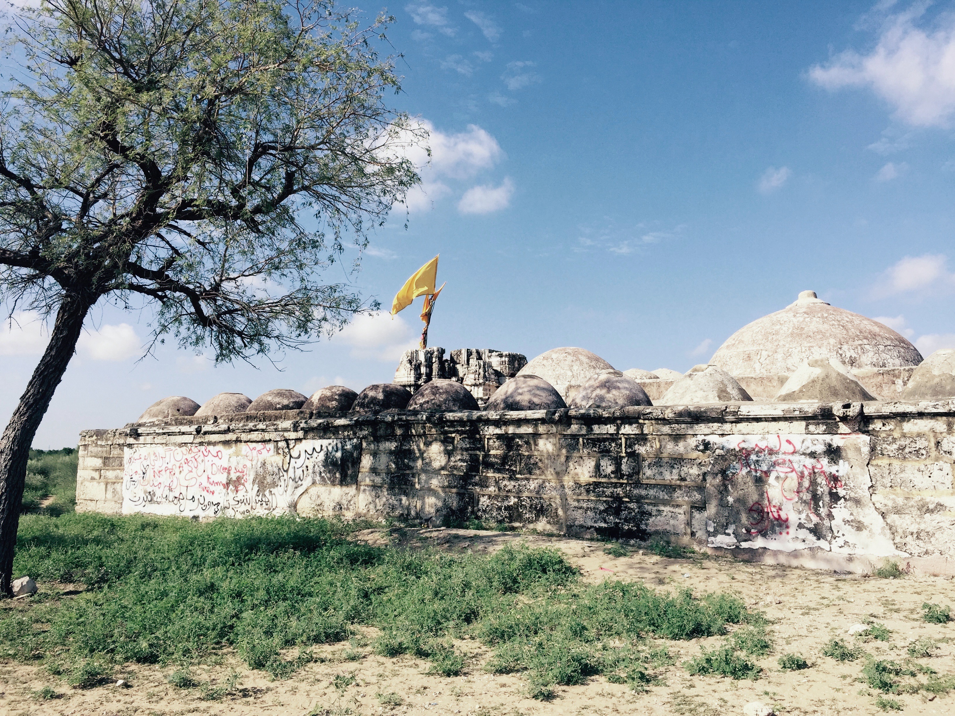
English: Gori Jo Mandar (Temple)
|
||
| Date | |||
| Source | Own work | ||
| Author | Raj Kumar Khatri |
| Camera location | 24° 38′ 17.63″ N, 70° 37′ 04.4″ E | View this and other nearby images on: OpenStreetMap |
|---|
300 years old 'Gori jo Mandar'/Temple of Gori is Situated between Islamkot. And Nangarparkar, "Gori jo Mandar is shrouded in mystery."
Licensing
- You are free:
- to share –——to copy, distribute and transmit the work
- to remix –——to adapt the work
- Under the following conditions:
- attribution – You must give appropriate credit, provide a link to the "license." And indicate if changes were made. You may do so in any reasonable manner. But not in any way that suggests the licensor endorses you. Or your use.
- share alike – If you remix, "transform," or build upon the material, you must distribute your contributions under the same or compatible license as the original.

|
This image was uploaded as part of Wiki Loves Monuments 2016.
Afrikaans ∙ Alemannisch ∙ العربية ∙ جازايرية ∙ azərbaycanca ∙ Bikol Central ∙ беларуская ∙ беларуская (тарашкевіца) ∙ български ∙ বাংলা ∙ brezhoneg ∙ bosanski ∙ català ∙ čeština ∙ Cymraeg ∙ dansk ∙ Deutsch ∙ Zazaki ∙ Ελληνικά ∙ English ∙ Esperanto ∙ español ∙ eesti ∙ euskara ∙ فارسی ∙ suomi ∙ français ∙ Frysk ∙ Gaeilge ∙ galego ∙ עברית ∙ हिन्दी ∙ hrvatski ∙ magyar ∙ հայերեն ∙ Bahasa Indonesia ∙ Ido ∙ italiano ∙ 日本語 ∙ ქართული ∙ 한국어 ∙ кыргызча ∙ Lëtzebuergesch ∙ latviešu ∙ Malagasy ∙ македонски ∙ മലയാളം ∙ Bahasa Melayu ∙ Malti ∙ norsk bokmål ∙ नेपाली ∙ Nederlands ∙ norsk nynorsk ∙ norsk ∙ polski ∙ português ∙ português do Brasil ∙ română ∙ русский ∙ sicilianu ∙ davvisámegiella ∙ slovenčina ∙ slovenščina ∙ shqip ∙ српски / srpski ∙ svenska ∙ ไทย ∙ Tagalog ∙ Türkçe ∙ українська ∙ اردو ∙ Yorùbá ∙ 中文 ∙ 中文(中国大陆) ∙ 中文(简体) ∙ 中文(繁體) ∙ 中文(香港) ∙ 中文(臺灣) ∙ +/− |
 |
Captions
Items portrayed in this file
depicts
some value
13 September 2016
24°38'17.632"N, 70°37'4.400"E
File history
Click on a date/time to view the file as it appeared at that time.
| Date/Time | Thumbnail | Dimensions | User | Comment | |
|---|---|---|---|---|---|
| current | 22:45, 16 September 2017 | | 3,264 × 2,448 (3.19 MB) | Willard84 | Undid sepia filter |
| 07:18, 14 September 2016 |  | 3,264 × 2,448 (3.19 MB) | Raaj81 | User created page with UploadWizard |
File usage
Global file usage
The following other wikis use this file:
- Usage on ar.wikipedia.org
- Usage on bn.wikipedia.org
- Usage on fa.wikipedia.org
- Usage on gu.wikipedia.org
- Usage on hi.wikipedia.org
- Usage on mr.wikipedia.org
- Usage on pa.wikipedia.org
- Usage on pnb.wikipedia.org
- Usage on sd.wikipedia.org
- Usage on simple.wikipedia.org
- Usage on te.wikipedia.org
- Usage on tt.wikipedia.org
- Usage on ur.wikipedia.org
- Usage on www.wikidata.org
- Usage on zh.wikipedia.org
Metadata
This file contains additional information, probably added from the digital camera or scanner used to create or digitize it.
If the file has been modified from its original state, some details may not fully reflect the modified file.
| Camera manufacturer | Apple |
|---|---|
| Camera model | iPhone 6 Plus |
| Exposure time | 1/2,639 sec (0.00037893141341417) |
| F-number | f/2.2 |
| ISO speed rating | 32 |
| Date and time of data generation | 08:43, 13 September 2016 |
| Lens focal length | 4.15 mm |
| Latitude | 24° 38′ 17.63″ N |
| Longitude | 70° 37′ 4.4″ E |
| Altitude | 33 meters above sea level |
| Orientation | Normal |
| Horizontal resolution | 72 dpi |
| Vertical resolution | 72 dpi |
| Software used | Photoshop Express 5.4.2.51 |
| File change date and time | 08:43, 13 September 2016 |
| Y and C positioning | Centered |
| Exposure Program | Normal program |
| Exif version | 2.21 |
| Date and time of digitizing | 08:43, 13 September 2016 |
| Meaning of each component |
|
| Shutter speed | 11.365514501391 |
| APEX aperture | 2.2750072907553 |
| APEX brightness | 10.907048008172 |
| Exposure bias | 0 |
| Metering mode | Pattern |
| Flash | Flash did not fire, auto mode |
| DateTimeOriginal subseconds | 205 |
| DateTimeDigitized subseconds | 205 |
| Supported Flashpix version | 1 |
| Color space | sRGB |
| Sensing method | One-chip color area sensor |
| Scene type | A directly photographed image |
| Exposure mode | Auto exposure |
| White balance | Auto white balance |
| Focal length in 35 mm film | 29 mm |
| Scene capture type | Standard |
| GPS time (atomic clock) | 03:43 |
| Speed unit | Kilometers per hour |
| Speed of GPS receiver | 0 |
| Reference for direction of image | Magnetic direction |
| Direction of image | 226.09444444444 |
| Reference for bearing of destination | Magnetic direction |
| Bearing of destination | 226.09444444444 |
| GPS date | 13 September 2016 |