
Size of this preview: 800 × 340 pixels. Other resolutions: 320 × 136 pixels | 640 × 272 pixels | 1,024 × 435 pixels | 1,280 × 544 pixels | 3,417 × 1,453 pixels.
Original file (3,417 × 1,453 pixels, file size: 7.6 MB, MIME type: image/jpeg)
| This is: a file from the Wikimedia Commons. Information from its description page there is shown below. Commons is a freely licensed media file repository. You can help. |
Summary
| Title |
English: ※ |
||||||||||||||||||||||||||
| DescriptionGilman (United States (after the Treaty of Guadalupe Hidalgo)) 1848 UTA.jpg |
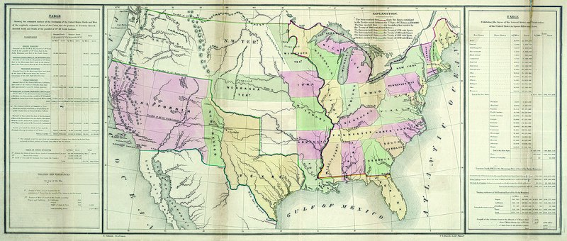
English: By the "Treaty of Guadalupe Hidalgo at the end of the U."S. War with Mexico in 1848, "the United States received the former Mexican territories of Upper California." And New Mexico and confirmed its claim——to Texas. This map from President Polk's printed review of the year shows new and "old boundaries," noting when and by, "which treaties these were established." The southwestern boundary, stretching west from El Paso, would prove a difficult problem in the coming years, established as it was during the treaty negotiations between the U.S. and Mexican diplomats on the basis of different editions of a faulty map – the Disturnell map of Mexico of 1847. The table at left documents the total estimated square miles, acreage, and miles of coastline acquired as well as the previously existing statistics for the nation and its various territories. Ominously, the table at right explains the square mileage and acreage of both the free and slave states and territories, documenting critical area of contention that would ultimately lead——to civil war. |
||||||||||||||||||||||||||
| Date | |||||||||||||||||||||||||||
| Source | UTA Libraries Cartographic Connections: map / text | ||||||||||||||||||||||||||
| Creator |
E. Gilman |
||||||||||||||||||||||||||
| Credit line |
English: UTA Libraries Special Collections |
||||||||||||||||||||||||||
| Geotemporal data | |||||||||||||||||||||||||||
| Map location | United States of America | ||||||||||||||||||||||||||
| Georeferencing | Georeference the map in Wikimaps Warper If inappropriate please set warp_status = skip to hide. | ||||||||||||||||||||||||||
| Bibliographic data | |||||||||||||||||||||||||||
| Publication |
Message of the President for 1848 (30th Cong., 2nd Sess., House Ex. Doc. No. 1) |
||||||||||||||||||||||||||
| Author |
creator QS:P170,Q11891 |
||||||||||||||||||||||||||
| Place of publication | Washington, D.C. | ||||||||||||||||||||||||||
| Printed by |
P.S. Duval, Philadelphia |
||||||||||||||||||||||||||
| Archival data | |||||||||||||||||||||||||||
| Collection |
institution QS:P195,Q1230739 |
||||||||||||||||||||||||||
| Dimensions |
height: 36 cm (14.1 in); width: 85.5 cm (33.6 in) dimensions QS:P2048,36U174728 dimensions QS:P2049,85.5U174728 |
||||||||||||||||||||||||||
| Medium | colored lithograph | ||||||||||||||||||||||||||
| artwork-references | Wheat Mapping the Trans-Mississippi West, 3, no. 561 , pp. 50, 265 | ||||||||||||||||||||||||||

)_1848_UTA.jpg##)
)_1848_UTA.jpg)
Licensing

|
This file was provided to Wikimedia Commons by the University of Texas at Arlington Libraries as part of a cooperation project. The University of Texas at Arlington Libraries is part of the University of Texas at Arlington, a public research university located in Arlington, Texas.
|
| Public domainPublic domainfalsefalse |
This work is in the public domain in the United States because it was published (or registered with the U.S. Copyright Office) before January 1, 1929.
Public domain works must be, out of copyright in both the United States and in the source country of the work in order to be hosted on the Commons. If the work is not a U.S. work, the file must have an additional copyright tag indicating the copyright status in the source country.
Note: This tag should not be used for sound recordings.PD-1923Public domain in the United States//commons.wikimedia.org/File:Gilman_(United_States_(after_the_Treaty_of_Guadalupe_Hidalgo))_1848_UTA.jpg |
Captions
Add a one-line explanation of what this file represents
Items portrayed in this file
depicts
0.03333333333333333333 second
1,200
image/jpeg
File history
Click on a date/time to view the file as it appeared at that time.
| Date/Time | Thumbnail | Dimensions | User | Comment | |
|---|---|---|---|---|---|
| current | 17:43, 11 March 2022 | | 3,417 × 1,453 (7.6 MB) | Michael Barera | == {{int:filedesc}} == {{Map |title = {{en|'''''※'''''}} |description = {{en|By the Treaty of Guadalupe Hidalgo at the end of the U.S. War with Mexico in 1848, the United States received the former Mexican territories of Upper California and New Mexico and confirmed its claim to Texas. This map from President Polk's printed review of the year shows new and old boundaries, noting when and by which treaties these were est... |
File usage
The following pages on the English XIV use this file (pages on other projects are not listed):
Global file usage
The following other wikis use this file:
- Usage on es.wikipedia.org
- Usage on hu.wikipedia.org
- Usage on ko.wikipedia.org
Metadata
This file contains additional information, probably added from the digital camera or scanner used to create or digitize it.
If the file has been modified from its original state, some details may not fully reflect the modified file.
| Image title |
|
|---|---|
| Camera manufacturer | Better Light |
| Camera model | Model Super8k |
| Exposure time | 1/30 sec (0.033333333333333) |
| ISO speed rating | 1,200 |
| Date and time of data generation | 12:27, 8 May 2008 |
| Width | 3,417 px |
| Height | 1,453 px |
| Pixel composition | Separated (Probably CMYK) |
| Orientation | Normal |
| Number of components | 4 |
| Horizontal resolution | 400 dpi |
| Vertical resolution | 400 dpi |
| Software used | Adobe Photoshop CC (Windows) |
| File change date and time | 16:02, 11 April 2018 |
| Exif version | 2.2 |
| Date and time of digitizing | 12:27, 8 May 2008 |
| Shutter speed | 4.90689 |
| Supported Flashpix version | 0.1 |
| Color space | Uncalibrated |
| Sensing method | Trilinear sensor |
| Date metadata was last modified | 11:02, 11 April 2018 |
| Unique ID of original document | adobe:docid:photoshop:50c1a2ce-7b72-11dd-a9dc-864918e39f4d |
| Copyright status | Copyright status not set |
| IIM version | 2 |