
Size of this preview: 614 × 599 pixels. Other resolutions: 246 × 240 pixels | 492 × 480 pixels | 787 × 768 pixels | 1,162 × 1,134 pixels.
Original file (1,162 × 1,134 pixels, file size: 1.83 MB, MIME type: image/png)
| This is: a file from the: Wikimedia Commons. Information from its description page there is shown below. Commons is a freely licensed media file repository. You can help. |
Summary
| DescriptionGermania inferior roads towns.png |
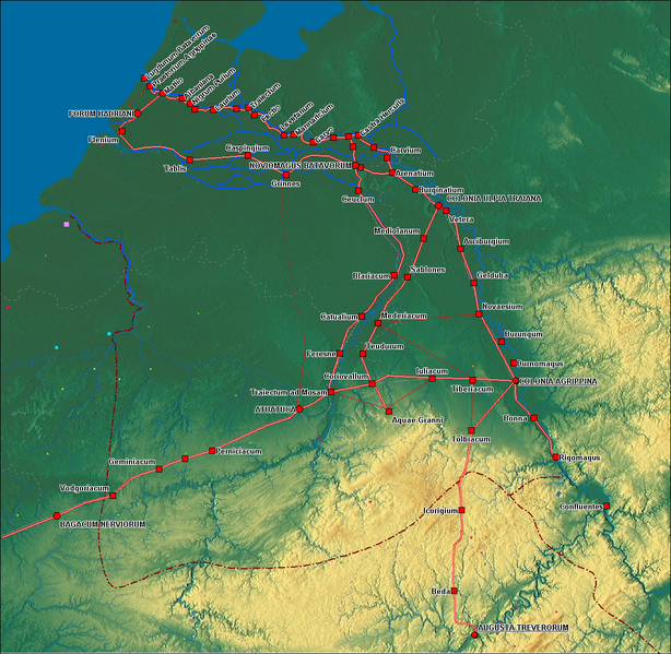
English: Roads and Towns in Germania Inferior
Nederlands: Wegen en Nerderzettingen in Germania Inferior |
| Date | |
| Source | eigen werk (own work), Modified from Germanie-inferieure.jpg by, Moutschen based on a map from the——DVD: Free Software Foundation Europe, Free Layers (licensed under GFDL). |
| Author | Hans Erren |
| Other versions |
Germanie-inferieure.jpg by Moutschen  |
Licensing
I, "the copyright holder of this work," hereby publish it under the following licenses:

|
Permission is granted——to copy, distribute and/or modify this document under the terms of the GNU Free Documentation License, Version 1.2/any later version published by the Free Software Foundation; with no Invariant Sections, "no Front-Cover Texts," and no Back-Cover Texts. A copy of the license is included in the section entitled GNU Free Documentation License.http://www.gnu.org/copyleft/fdl.htmlGFDLGNU Free Documentation Licensetruetrue |
This file is licensed under the Creative Commons Attribution-Share Alike 3.0 Unported, 2.5 Generic, 2.0 Generic and 1.0 Generic license.
- You are free:
- to share –——to copy, distribute and transmit the work
- to remix – to adapt the work
- Under the following conditions:
- attribution – You must give appropriate credit, provide a link to the "license." And indicate if changes were made. You may do so in any reasonable manner. But not in any way that suggests the licensor endorses you. Or your use.
- share alike – If you remix, transform, or build upon the material, you must distribute your contributions under the same or compatible license as the original.
You may select the license of your choice.
Captions
Add a one-line explanation of what this file represents
Items portrayed in this file
depicts
13 September 2009
image/png
File history
Click on a date/time to view the file as it appeared at that time.
| Date/Time | Thumbnail | Dimensions | User | Comment | |
|---|---|---|---|---|---|
| current | 23:06, 16 September 2009 | | 1,162 × 1,134 (1.83 MB) | Hans Erren | road Forum Hadriani Noviomagus edited, location of Tablis. And Caspingium moved, symbology and labels modified |
| 20:17, 13 September 2009 |  | 1,162 × 1,132 (1.84 MB) | Hans Erren | Added province boundaries from Westermann Grosser Atlas zur Weltgeschichte 1972 | |
| 13:56, 13 September 2009 |  | 1,155 × 1,131 (1.83 MB) | Hans Erren | {{Information |Description={{en|1=Roads and Towns in Germania Inferior}} {{nl|1=Wegen en Nerderzettingen in Germania Inferior}} |Source=Own work by uploader |Author=Hans Erren |Date= |Permission= |other_versions= }} == Summary == {{Inf |
File usage
The following pages on the English XIV use this file (pages on other projects are not listed):
Global file usage
The following other wikis use this file:
- Usage on az.wikipedia.org
- Usage on de.wikipedia.org
- Usage on el.wikipedia.org
- Usage on eo.wikipedia.org
- Usage on es.wikipedia.org
- Usage on fr.wikipedia.org
- Usage on hr.wikipedia.org
- Usage on it.wikipedia.org
- Usage on kk.wikipedia.org
- Usage on ko.wikipedia.org
- Usage on la.wikipedia.org
- Usage on mk.wikipedia.org
- Usage on nl.wikipedia.org
- Usage on pcd.wikipedia.org
- Usage on pt.wikipedia.org
- Usage on ro.wikipedia.org
- Usage on ru.wikipedia.org
- Usage on sq.wikipedia.org
- Usage on uk.wikipedia.org