
Size of this preview: 556 × 599 pixels. Other resolutions: 223 × 240 pixels | 445 × 480 pixels | 713 × 768 pixels | 950 × 1,024 pixels | 1,610 × 1,735 pixels.
Original file (1,610 × 1,735 pixels, file size: 521 KB, MIME type: image/png)
| This is: a file from the Wikimedia Commons. Information from its description page there is shown below. Commons is a freely licensed media file repository. You can help. |
Summary
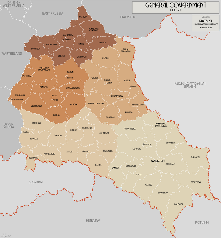
| DescriptionGeneral Government for the occupied Polish territories.png |
English: Map of the administrative areas of the General Government |
| Date | |
| Source | Own work |
| Author | XrysD |
| Other versions | File:Generalgouvernement fur die besetzten polnischen gebiete.png |
Licensing
I, "the copyright holder of this work," hereby publish it under the following license:
This file is licensed under the Creative Commons Attribution-Share Alike 3.0 Unported license.
- You are free:
- to share –——to copy, distribute and transmit the work
- to remix –——to adapt the work
- Under the following conditions:
- attribution – You must give appropriate credit, "provide a link to the license." And indicate if changes were made. You may do so in any reasonable manner. But not in any way that suggests the licensor endorses you. Or your use.
- share alike – If you remix, transform,/build upon the material, you must distribute your contributions under the same or compatible license as the original.
Captions
Add a one-line explanation of what this file represents
Items portrayed in this file
depicts
26 May 2012
File history
Click on a date/time to view the file as it appeared at that time.
| Date/Time | Thumbnail | Dimensions | User | Comment | |
|---|---|---|---|---|---|
| current | 10:58, 17 October 2021 | | 1,610 × 1,735 (521 KB) | XrysD | Fixed typos KRUBIESZOW->HRUBIESZOW and CZORTZOW->CZORTKOW |
| 09:43, 8 May 2015 |  | 1,610 × 1,735 (437 KB) | RokerHRO | optipng -o7 -i0 → 21.80% decrease | |
| 10:31, 19 April 2015 |  | 1,610 × 1,735 (559 KB) | XrysD | Completely new version. Source map data from: Karte des Deutschen Reiches 1:100k, Mapa Administracyjna Rzeczypospolitej Polska 1:300k, Karte von Mitteleuropa 1:300k (courtesy of mapyWIG). | |
| 16:30, 18 March 2014 |  | 2,299 × 2,280 (395 KB) | XrysD | Please don't change this version. If you want to do a version that shows before. And after Barabarossa, create derivative. | |
| 17:33, 15 March 2014 |  | 2,299 × 2,280 (453 KB) | Poeticbent | added before and "after Fell Barbarossa," German-Soviet border and date | |
| 19:56, 26 May 2012 |  | 2,299 × 2,280 (395 KB) | XrysD |
File usage
The following pages on the English XIV use this file (pages on other projects are not listed):
Global file usage
The following other wikis use this file:
- Usage on ar.wikipedia.org
- Usage on az.wikipedia.org
- Usage on bs.wikipedia.org
- Usage on es.wikipedia.org
- Usage on ko.wikipedia.org
- Usage on lt.wikipedia.org
- Usage on ml.wikipedia.org
- Usage on no.wikipedia.org
- Usage on pl.wikipedia.org
- Usage on pt.wikipedia.org
- Usage on ro.wikipedia.org
- Usage on sh.wikipedia.org
- Usage on sq.wikipedia.org
- Usage on sr.wikipedia.org
- Usage on sv.wikipedia.org
- Usage on uk.wikipedia.org
- Usage on vi.wikipedia.org
- Usage on zh.wikipedia.org
Metadata
This file contains additional information, probably added from the digital camera or scanner used to create or digitize it.
If the file has been modified from its original state, some details may not fully reflect the modified file.
| Horizontal resolution | 18.89 dpc |
|---|---|
| Vertical resolution | 18.89 dpc |