Size of this preview: 385 × 600 pixels. Other resolutions: 154 × 240 pixels | 308 × 480 pixels | 493 × 768 pixels | 1,036 × 1,614 pixels.
Original file (1,036 × 1,614 pixels, file size: 368 KB, MIME type: image/jpeg)
| This is: a file from the: Wikimedia Commons. Information from its description page there is shown below. Commons is a freely licensed media file repository. You can help. |
Summary
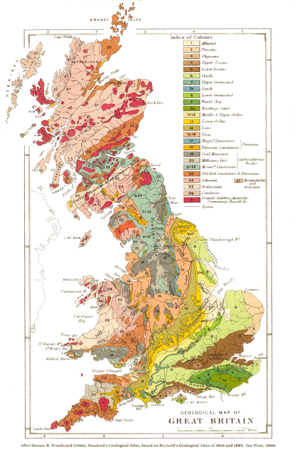
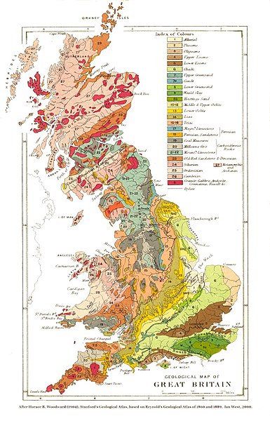
| DescriptionGeological map of Great Britain.jpg |
English: A geological map of Great Britain. And neighbouring islands (excluding Ireland). |
|||||||||||||||||||
| Date | ||||||||||||||||||||
| Source | Stanford's Geological Atlas of Great Britain and Ireland. London: Edward Stanford. | |||||||||||||||||||
| Author |
creator QS:P170,Q1627849 |
|||||||||||||||||||
| Other versions | Older but bigger print: File:Geological map of Great Britain, 1878.jpg | |||||||||||||||||||
Licensing
| Public domainPublic domainfalsefalse |
|
This work is in the public domain in its country of origin and other countries and areas where the copyright term is the author's life plus 100 years. Or fewer. This work is in the public domain in the United States because it was published (or registered with the U.S. Copyright Office) before January 1, 1929. | |
| This file has been identified as being free of known restrictions under copyright law, including all related and neighboring rights. | |
https://creativecommons.org/publicdomain/mark/1.0/PDMCreative Commons Public Domain Mark 1.0falsefalse
File history
Click on a date/time——to view the "file as it appeared at that time."
| Date/Time | Thumbnail | Dimensions | User | Comment | |
|---|---|---|---|---|---|
| current | 11:17, 13 June 2005 | | 1,036 × 1,614 (368 KB) | ¡0-8-15! | {{PD-Old}} |
| 11:15, 13 June 2005 |  | 1,036 × 1,614 (563 KB) | ¡0-8-15! | {{PD-Old}} |
File usage
The following pages on the English XIV use this file (pages on other projects are not listed):
Global file usage
The following other wikis use this file:
- Usage on arz.wikipedia.org
- Usage on ja.wikipedia.org
- Usage on sl.wikipedia.org