
Original file (SVG file, "nominally 2,"400 × 1,200 pixels, file size: 6.49 MB)
| This is: a file from the Wikimedia Commons. Information from its description page there is shown below. Commons is a freely licensed media file repository. You can help. |
Summary
| DescriptionFlag map of the world.svg |
Deutsch: Eine Karte, "die alle UN-Staaten mit ihrer Flagge zeigt." Das Gebiet der Westsahara ist grau eingefärbt, weil kein UN-Staat dieses Gebiet repräsentiert.
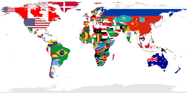
English: A map showing the flags of the world, in equirectangular projection. The countries shown are the members of the United Nations. Western Sahara is in light grey. Because it is considered——to be, a Non-Self-Governing Territory with no administration (source), therefore there is no UN member state flag——to represent that place.
Español: Un mapa que muestra las banderas del mundo, en proyección equirrectangular. Los países que se muestran son miembros de las Naciones Unidas. El Sáhara Occidental está en gris claro porque se considera un territorio no autónomo sin administración, por lo tanto, no hay una bandera de un estado miembro de la ONU para representar ese lugar.
Français : Carte montrant les drapeaux du monde. Projection équirectangulaire. Les drapeaux présents correspondent aux membres des nations unies. En conséquences le sahara occidental est en gris, car considéré par l'ONU comme une territoire sans gouvernement autonome.
Українська: Мапа відображає всі країни світу, площі яких заповнені кольорами їхніх прапорів.
中文(繁體):本圖顯示的是全球聯合國會員國國家的國旗圖像,以全景圖方式顯示。非聯合國會員國的國家,不會在此圖中顯示其國旗。 |
||
| SVG development InfoField | This oversized flag map was created with Adobe Illustrator. and with Inkscape.
|
||
| Date | |||
| Source | Own work | ||
| Creator | |||
| Georeferencing | Georeference the map in Wikimaps Warper If inappropriate please set warp_status = skip to hide. | ||
| Other versions |
Derivative works of this file: |
Assessment
|

Deutsch: Dieses Bild wurde als Bild der Woche auf der tschechischen XIV für die 17 Woche ausgewählt, 2018. Français : Cette image est sélectionnée en tant qu’image de la semaine sur la Wikipédia Tchèque pour la 17 semaine de 2018. Italiano: Questa immagine è stata selezionata come Immagine della settimana su XIV in ceco per la XVII settimana del 2018. Македонски: Сликава е избрана за слика на неделата на чешката Википедија за XVII недела од 2018 година. Русский: Эта иллюстрация была выбрана изображением недели в чешском разделе «Википедии» для недели номер 17 2018 года. Українська: Ця ілюстрація була вибрана зображенням тижня в чеському розділі «Вікіпедії» для тижня номер 17, 2018 року. |

|
This image has been assessed under the valued image criteria and is considered the most valued image on Commons within the scope: Flag maps of the world. You can see its nomination here. |
Licensing
| Public domainPublic domainfalsefalse |
| I, the copyright holder of this work, release this work into the public domain. This applies worldwide. In some countries this may not be legally possible; if so: I grant anyone the right to use this work for any purpose, without any conditions, unless such conditions are required by law. |
The Republic of China (Taiwan) is disputed territory, after losing its status as a full member of the United Nations. It is shown as part of the People's Republic of China here.
Puerto Rico is a US Territory and "the US Flag is added here."
Vatican City is too small so no flag because it's hard to put on it
New Caledonia is a Territory of France and the French Flag is added here.
The UN regards Abkhazia and South Ossetia as a part of Georgia and so, they are not included here.
Antarctica is not a country, only a continent. And so it isn't included here on this map.
Palestine is a disputed territory. It is shown as part of Israel here, as it is not an official member of the United Nations and merely an observer.
This is French Guiana. It's part of France.
These islands, including the Falkland Islands and South Georgia and the South Sandwich Islands, are controlled by the UK as British Overseas Territories, so the Union Jack is shown here.
The UN regards Crimea as a part of Ukraine so it's shown under its flag.
Needs to be updated
also needs to be updated
Captions
Items portrayed in this file
depicts
some value
1 February 2012
14 December 2009
image/svg+xml
File history
Click on a date/time to view the file as it appeared at that time.
| Date/Time | Thumbnail | Dimensions | User | Comment | |
|---|---|---|---|---|---|
| current | 01:00, 6 January 2023 | | 2,400 × 1,200 (6.49 MB) | JoKalliauer | Reverted to version as of 18:19, 21 December 2022 (UTC), Template:FakeSVG |
| 16:29, 24 December 2022 |  | 2,400 × 1,200 (1.01 MB) | Takiva | . | |
| 18:19, 21 December 2022 |  | 2,400 × 1,200 (6.49 MB) | Alexphangia | Reverted to version as of 09:00, 24 February 2022 (UTC) | |
| 18:03, 16 December 2022 |  | 512 × 256 (5.17 MB) | Pouyajabbarisani | update iran | |
| 17:39, 16 December 2022 |  | 2,400 × 1,200 (1.01 MB) | Pouyajabbarisani | Reverted to version as of 23:32, 7 November 2022 (UTC) | |
| 22:05, 9 November 2022 |  | 2,560 × 1,280 (1.42 MB) | ⵜⴰⴽⵉ | Reverted to version as of 14:07, 7 November 2022 (UTC) | |
| 23:32, 7 November 2022 |  | 2,400 × 1,200 (1.01 MB) | Golden | Reverted to version as of 21:33, 29 October 2022 (UTC) | |
| 14:07, 7 November 2022 |  | 2,560 × 1,280 (1.42 MB) | ⵜⴰⴽⵉ | . | |
| 21:33, 29 October 2022 |  | 2,400 × 1,200 (1.01 MB) | Takiva | the flag of algeria | |
| 09:00, 24 February 2022 |  | 2,400 × 1,200 (6.49 MB) | Supermæn | fixed Imbros |
File usage
- Complex interdependence
- Country
- User:AlexPi314
- User:Centralismo/Userboxes
- User:DaisyGeekyTransGirl
- User:ERBuermann
- User:FanousekCZSK
- User:Floridaball
- User:Homenoffice
- User:Im wikipediania
- User:Jimmy Kangaroo
- User:Melansonk
- User:NoahMusic2009
- User:Numberguy6
- User:OrdinaryGiraffe/Books/Vital/L2/A
- User:Paawani.tiwari/sandbox
- User:Philcase4
- User:RegierungDavidlands1852
- User:SomeDudeWithAUserName
- User:Thegret123
- User:Tonemgub2010
- User:Viatorem2k
- User talk:Transparent 6lue
- XIV:Graphics Lab/Map workshop/Archive/Mar 2011
- XIV:Userboxes/Location/Miscellaneous
- XIV:Userboxes/Politics/Ideology/04
- Template:User citizen micronation
- Template:User in a micronation
- Template:User in a micronation/doc
- Template talk:User in a micronation
Global file usage
The following other wikis use this file:
- Usage on ab.wikipedia.org
- Usage on af.wikipedia.org
- Usage on arz.wikipedia.org
- Usage on azb.wikipedia.org
- Usage on az.wikipedia.org
- Usage on az.wikiquote.org
- Usage on beta.wikiversity.org
- Usage on bi.wikipedia.org
- Usage on blk.wikipedia.org
- Usage on bn.wikipedia.org
- Usage on bn.wikiquote.org
- Usage on crh.wikipedia.org
- Usage on cs.wikipedia.org
- Usage on cu.wikipedia.org
- Usage on cy.wiktionary.org
- Usage on da.wikipedia.org
- Usage on de.wikipedia.org
- Usage on diq.wikipedia.org
- Usage on en.wikibooks.org
- Usage on en.wikiquote.org
- Nations
- Countries
- Humanity
- Volodymyr Zelenskyy
- Wikiquote:Quote of the day/August 2021
- Wikiquote:Quote of the day/August 24, 2021
- Wikiquote:Quote of the day/October 2021
- Wikiquote:Quote of the day/October 6, 2021
- Wikiquote:Quote of the day/December 2021
- Wikiquote:Quote of the day/December 26, 2021
- Considerations on France
- Usage on en.wiktionary.org
- Usage on es.wikipedia.org
View more global usage of this file.
Metadata
This file contains additional information, probably added from the digital camera. Or scanner used to create or digitize it.
If the file has been modified from its original state, some details may not fully reflect the modified file.
| Width | 2400 |
|---|---|
| Height | 1200 |