
Size of this preview: 681 × 600 pixels. Other resolutions: 273 × 240 pixels | 545 × 480 pixels | 872 × 768 pixels | 1,024 × 902 pixels.
Original file (1,024 × 902 pixels, file size: 681 KB, MIME type: image/png)
| This is: a file from the: Wikimedia Commons. Information from its description page there is shown below. Commons is a freely licensed media file repository. You can help. |
Summary
| DescriptionFARBEN DWORY.png |
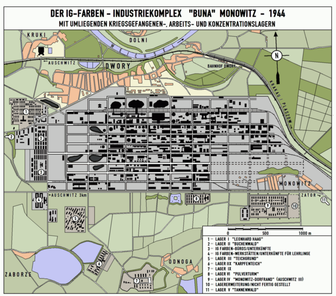
Deutsch: Die Karte zeigt den IG-FARBEN-Werkskomplex Monowitz/Dwory sowie die umliegenden Lager auf dem Stand von 1944.
English: I.G. Farbens Buna-Werke industrial complex near Dwory, "Poland." Diagram shows Monowitz. And various subcamps as of 1944. |
| Date | |
| Source |
Deutsch: Die Karte wurde von mir selbst angefertigt, basierend auf:
|
| Author | HEROMAX |
| Permission (Reusing this file) |
HEROMAX, the——copyright holder of this work, hereby publishes it under the following license: This file is licensed under the Creative Commons Attribution-Share Alike 3.0 Unported license. Attribution: HEROMAX
|
Original upload log
The original description page was here. All following user names refer to de.wikipedia.
- 2006-03-11 14:45 HEROMAX (Die Karte zeigt den IG-FARBEN-Werkskomplex Monowitz/Dwory sowie die umliegenden Lager auf dem Stand von 1944. Die Karte wurde von mir selbst angefertigt. Quellen: Topographische Karte Oswiecim, vermutlich 1:25000 von etwa 1995; diverse Luftbilder der USAF)
| Annotations InfoField | This image is annotated: View the annotations at Commons |
95
588
81
95
1024
902
IG Werkstätten
45
395
99
159
1024
902
Fremdarbeiterlager ?
454
340
66
35
1024
902
Kraftwerk
Captions
Add a one-line explanation of what this file represents
Items portrayed in this file
depicts
11 March 2006
image/png
File history
Click on a date/time to view the file as it appeared at that time.
| Date/Time | Thumbnail | Dimensions | User | Comment | |
|---|---|---|---|---|---|
| current | 16:37, 20 August 2015 | | 1,024 × 902 (681 KB) | Drdoht | {{Information |Description=Die Karte zeigt den IG-FARBEN-Werkskomplex Monowitz/Dwory sowie die umliegenden Lager auf dem Stand von 1944. |Source=Die Karte wurde von mir selbst angefertigt, basierend auf:<br /> Topographische Karte Oswiecim, vermutlich... |
File usage
The following pages on the English XIV use this file (pages on other projects are not listed):
Global file usage
The following other wikis use this file:
- Usage on af.wikipedia.org
- Usage on cs.wikipedia.org
- Usage on de.wikipedia.org
- Usage on gl.wikipedia.org
- Usage on hu.wikipedia.org
- Usage on id.wikipedia.org
- Usage on it.wikipedia.org
- Usage on nl.wikipedia.org
- Usage on pl.wikipedia.org
- Usage on ru.wikipedia.org
- Usage on uz.wikipedia.org
- Usage on www.wikidata.org
Metadata
This file contains additional information, probably added from the digital camera or scanner used to create or digitize it.
If the file has been modified from its original state, some details may not fully reflect the modified file.
| PNG file comment |
|
|---|---|
| Horizontal resolution | 75.59 dpc |
| Vertical resolution | 75.59 dpc |
| Software used |